Maps, Mounts and Models from Scotland’s Six World Heritage Sites

Scotland has an impressive six UNESCO World Heritage Sites which represent unique (or the most significant or best) examples of the world’s cultural heritage and have a special importance for everyone, including those outside of Scotland and future generations.
Six experts weigh in on their favourite artefacts, buildings and objects associated with these sites, which cover over 5,000 years of history from stone to steel:
St Kilda – Notes and Emendations: Sharbau’s Plan of St Kilda
One of the most fascinating objects tied to St Kilda (pictured above) may not be the pottery or metalwork which you would usually associate with archaeology. It’s a map – a plan made by Henry Sharbau, assistant to then Commander F.W.L Thomas, of Her Majesty’s Navy. The map (page 14) has long been known as an important course for understanding life on St Kilda but it is only recently that archaeological research has revealed the true nature of this unusual object.
A note on the plan in shaky pencil says ‘Thursday, Friday, July 8, 9 1858’. Consequently, it was always believed this is when the map was made. However, detailed research has shown that Sharbau did not visit until 1860, and the map shows changes to St Kilda’s Village dating from 1861. This contradiction made it hard to interpret and understand the map.
Research brought out a strange coincidence – the date in pencil is also the exact the date of a visit to St Kilda by Thomas Muir, a founder member of the Society of Antiquaries of Scotland. The archive of F.W.L. Thomas, also a founder member, was donated to the Society, including Sharbau’s plan, and it was likely there where Muir noted the date of his own visit, perhaps as a reminder.
Solving this mystery allowed landscape archaeologists to unlock the secrets of the map, which captured the community of St Kilda at a time of significant change. You can find out more about what was discovered and see more detail of the plan by reading the research paper.
The Antonine Wall – A Jewel in the Kinneil Crown
Visiting Kinneil Estate near Bo’ness in central Scotland like travelling back through time. The House is known for its 16th-century wall paintings and nearby is inventor James Watt’s 18th-century cottage where he worked on his development of the steam engine. But if you explore the parkland you will find a set of timber posts right in the middle of the lawn which mark out a Roman fortlet, once part of the Antonine Wall.
During excavations in 1978-1980, amongst the everyday finds of shoes, pots and bones was this little bronze harness mount. It originally had two projecting rectangular loops attached to the back, one of which survives. These would have held, or fastened onto, leather straps that formed part of the horse harness. The front is beautifully decorated with a S-scroll and two domed mounts, forming a leaf-like pattern. You can see it “for real” at the Kinneil Museum or explore a 3D version on Sketchfab.
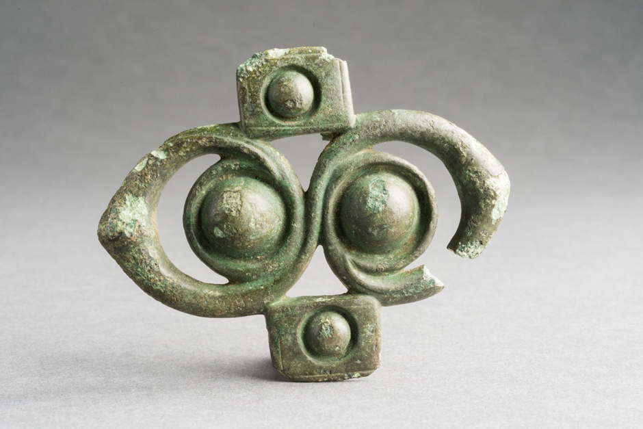
The Harness Mount © Historic Environment Scotland. The harness mount (or a version of it) now has a more prominent place in Kinneil Estate. As part of the Rediscovering the Antonine Wall project, funded by the National Lottery Heritage Fund and LEADER, the local community commissioned sculptor Phil Neal to create an 8 x 6 ft replica, which has been set on a stone plinth at the entrance of Kinneil Estate to allow even more people to be able to marvel at, and enjoy, this amazing Roman design.
Edinburgh Old and New Town – Take the Weight off Your Feet in Tweeddale Court
This small stone building in Tweeddale Court is known as sedan chair house. It was used to store the sedan chairs which provided a transport service in the Old Town of Edinburgh for over a hundred years.
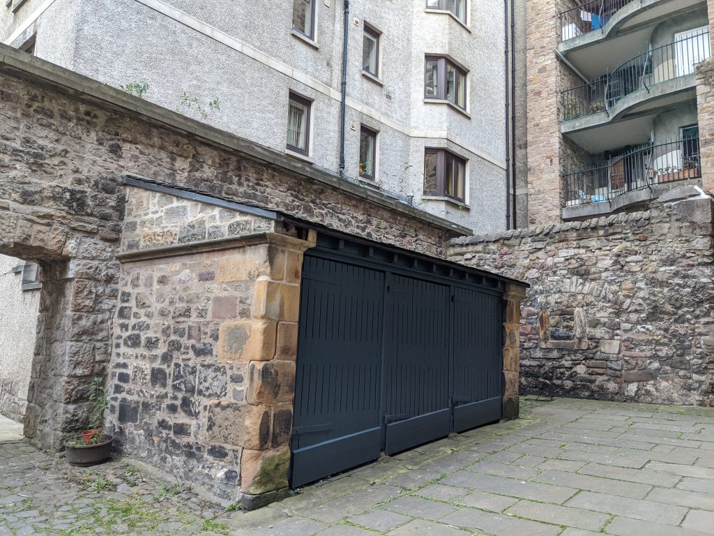
Sedan Chair House in Tweeddale Court
The hackney sedans were constructed of wood with a black leather covering and were fitted with a cushioned seat. Privately owned chairs were much more elaborate with fine embossed leather, stamped metalwork, pastoral paintings, carvings and gilding. The sedan door was normally at the front, but most Edinburgh chairs had a door at the side to allow easier access from doorways in the narrow closes and wynds. Another Edinburgh adaptation was the pivoting seat that kept passengers in a horizontal position on the steep inclines in the Old Town.
Six sedan chairs for public hire were introduced to Edinburgh in 1687. They were a particularly suitable alternative to horse-drawn coaches, which struggled in narrow closes and steep hills of the Old Town. By 1779 there were 180 for hire and 50 private chairs in the city. The main sedan-chair stance was at the Tron Kirk, which is also home to the archaeological remains of Marlin’s Wynd, the earliest paved street in Scotland.
The ‘ladies of nobility and quality’ who used them for trips to dance assemblies and the theatre could be sure, doubtless at a price, of a small lantern to light the sedan and a hot water pan placed under the seat. A particularly eccentric Edinburgh judge never used a sedan himself but is said to have had his wig sent home in one when it rained. A sedan was even kept by the Royal Infirmary as an ambulance. Why not have a go at making your own?
The Heart of Neolithic Orkney – The Detail in the Map
Orkney in the 1830s saw a changing landscape – the once lucrative kelp industry had all but collapsed and areas of moorland were, for the first time, being brought into cultivation. Mounds and tombs were discovered, opened or removed. Most went unrecorded.
At the same time an increasing demand for topographical and hydrographical surveys resulted in the first true, accurate maps of Orkney. These maps are vital for capturing details in the landscape that have since been lost to cultivation and improvement.
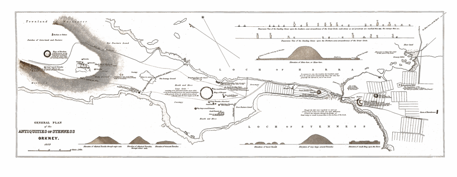
Thomas Map of Stenness – Brodgar © Crown Copyright
This includes the now famous, impressively detailed, topographical map of the Stenness – Brodgar area, which is now part of the landscape of the Heart of Neolithic World Heritage Site.
The map was produced in 1852 by Captain F.W.L Thomas, an admiralty hydrographer (someone who studies, surveys and maps the oceans, seas, and rivers) who surveyed Orkney between 1848 -50 from HMS Woodlark. With our ever-changing understanding of the World Heritage landscape, Thomas’s map is a document where the detailed drawings are as relevant today as they were 170 years ago.
New Lanark – A Classroom Frozen in Time
Robert Owen, owner and manager of the New Lanark Mills from 1800-1825, was far in advance of his time. He believed that every person had a right to leisure time and a ‘rational system of education’, which included not only reading, writing and arithmetic, but also music, dancing, nature study and the arts.
This attractive painting by G. Hunt of a dancing class in Owen’s ‘Institute for the Formation of Character’ shows children from New Lanark being instructed by a dancing master whilst Owen and several visitors looks on. The children are wearing Roman-style tunics made from New Lanark cotton and the features of the classroom, including a large frieze depicting exotic animals by Catherine Vale Whitwell, and a map of Europe, can be seen in the background.
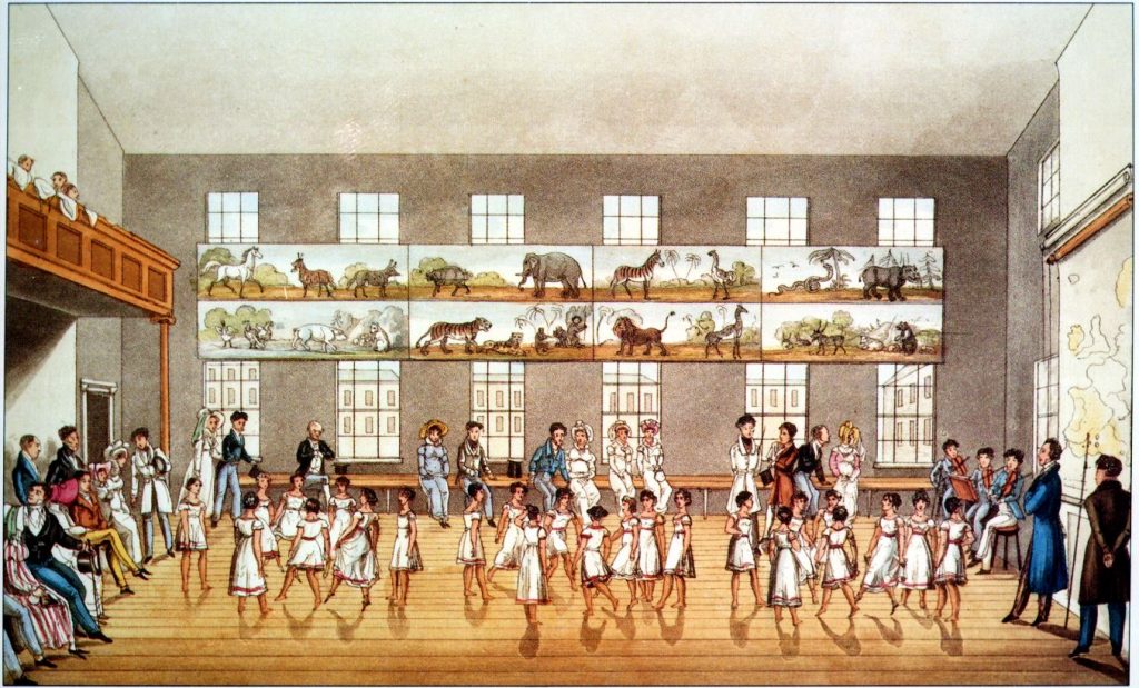
New Lanark Dancing Classes – Image Copyright New Lanark Trust
Children who visit New Lanark can now take part in a recreation of an Owen-period school lesson in the School for Children – writing on slate, maths on an abacus, geography on a giant globe, and of course, taking part in a dancing lesson.
The Forth Bridge – The Silvery Forth: A Model for Public Reassurance
A world heritage site demonstrates Outstanding Universal Value through physical attributes of a place. Associated objects and archives help to give context, while not themselves forming the world heritage list. Two scale models of the Forth Bridge are objects which, being portable, can be shown separately from the property.
The first of these is a silver-plated model ascribed by its owner the Science Museum to 1882-1890. However photographs of that same model, with a draped backdrop and scale model ships, were published along with the parliamentary bill in May 1882 so we can be more precise. When the bridge opened on 4 March 1890, the guests convened at a “model room” to see it – possibly the blonde stone building now containing an architects’ office and take-away next to Dalmeny Station.

Silver Model of the Forth Bridge in the Science Museum
A model Forth Bridge of similar dimensions was displayed at a celebration marking the 130th anniversary of the opening in 2020. This model by Michael Dineen (Transport Scotland) is very different from the 1882 Silver model as it is made of Lego! If you would like to assemble a Lego Forth Bridge too, you can encourage Lego to make purpose-built kit.
If you’d like to learn more about Scotland’s World Heritage Sites, visit the Historic Environment Scotland website.
By Kevin Grant (Archaeology Manager | Historic Environment Scotland), Séverine Peyrichou (Rediscovering the Antonine Wall Project Development Officer | West Dumbartonshire Council), Jenny Bruce (Edinburgh Old and New Town World Heritage Site Co-ordinator), Elaine Clarke (Orkney Ranger | Historic Environment Scotland), Jane Masters (Head of Heritage | New Lanark) and Mark Watson (Deputy Head of Industrial Heritage | Historic Environment Scotland)
Header Image: Village Bay in 2018 by Craig Stanford
