Finding the Stone Age in Scotland: Your Guide to the Fun World of Fieldwalking

The main archaeological evidence for the people who lived in Scotland in earlier prehistory (Palaeolithic – Neolithic, roughly 14,000 to 4,500 years ago) is made up of stone tools (hence: the Stone Age). These are often found as scatters eroding on the surface of the ground, perhaps where they have been pulled to the surface by the plough. It is an important part of archaeology to collect and record them, and it is one which everyone can join.
Community groups all over Scotland, like Mesolithic Deeside in Aberdeenshire, are making a significant contribution to our understanding of the ancient populations of Scotland through their fieldwalking activities.
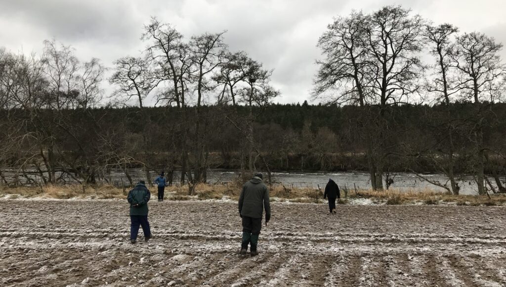
The Mesolithic Deeside team at work: the stone tools can be more visible after weathering such as rainfall or frost (Image credit: Mesolithic Deeside)
Lithic Scatters: key evidence
Where stone tools are found on the surface of the ground the sites are known as lithic scatters, referring to the fact that they comprise mainly the remnants of making and using stone tools. Most of the other materials in use in prehistory have long since disappeared into Scotland’s acid soils.
While flint was an important raw material, stone tools were also made from a range of other stones such as quartz, chert, and pitchstone, so that we tend to refer to lithics rather than the (slightly old fashioned) flint.
The lithic scatter is a good sign that activity has taken place in the past, but it is hard to tell how much archaeology survives on a site. Some scatter sites may conceal buried features such as pits, hearths, and post holes that survive below the ploughsoil and these provide additional information.
But these features are fragile, and, in many cases, the scatter of stone tools may be all that survives of a site that has been otherwise destroyed. For this reason, it is important to record as much information about a scatter site as we can.

Microliths like these from the island of Rùm in Na h-Eileanan a-staigh (the Inner Hebrides) are a classic sign of activity in the Mesolithic, between 8,000 – 4,000 BC. They give you a good idea of the tiny size of some stone tools. These pieces were hafted into tools like arrowheads (Image credit: Caroline Wickham-Jones)
Fieldwalking to find sites
Fieldwalking is not difficult, and it is an activity in which everyone can participate no matter how much (or little) archaeological experience you have. It is fun! And, of course, it is rewarding when you make a find.
Step one is to identify suitable fields. It is important to work closely with the farmers, or landowners, and seek all necessary permissions to access the land.
Some projects will walk any field regardless of the possibility of finding material, while others will undertake a quick recce of recently ploughed or harrowed fields in order to assess the likelihood that material might be visible.
It is also important to check pre-existing information about a potential site using the local Historic Environment Record or Pastmap and make sure that it is not protected in any way, for example by Scheduling, because this would mean that you should not work there. Working with the farmer ensures that damage and disruption to the agricultural round does not occur.

It is important to liaise with the farmer or landowner for permission and to make sure that you do not disrupt farm work (Image credit: Mesolithic Deeside)
What to expect while fieldwalking
Stone tools can be very small, and visibility is best once a ploughed field has been weathered, perhaps a few days after rain or frost. The aim of the fieldwalking is to cover as much of the surface of the field as possible, but it is important to be able to record where the finds occur. Waterproof, permanent, pens, and a good supply of tiny sealable ‘finds bags’ are essential equipment.
By walking in straight lines across the ploughed surface it is possible to record roughly how much of the field is covered, and a digital GPS (available as a smartphone app), can be used to record the location of individual finds which are numbered and bagged so that they can be linked back to their position. A digital Global Positioning System (dGPS) uses satellite technology to provide an accurate reading of the position of the reader in terms of altitude, latitude, and longitude. Each reading is identified by a unique number and if these are transcribed on to the finds bag then the location of that particular worked stone or other artefact is known.
Many groups spread out and walk in rows with people spaced two metres apart. This allows the team to chat, while scanning the ground surface a metre either side of you for finds. The spacing of individual transects can be increased which speeds up work without a meaningful loss of data, but, of course, it makes it harder to chat.

Using a digital GPS is not difficult: digital GPS, finds bags, and a typical worked flint (Image credit: Mesolithic Deeside)
What have you found?
If possible, finds should be catalogued straight after fieldwalking. Mesolithic Deeside pass theirs to a professional lithic specialist who compiles a basic catalogue of the types of stone tool found (see the Working Stone website for a great guide to the different types of stone tool). This allows a spatial map of the field to be made, using the dGPS coordinates, and this highlights any concentrations of material such as a particular type or period of find, which adds to the interpretation of the work.
Finds are carefully stored and at the end of each season a report is written for the County Archaeologist, Discovery and Excavation in Scotland, and local museums, as well as any funders. Copies of the archive are lodged with the local Historic Environment Record and Historic Environment Scotland so that future archaeologists will be able to use them, and the finds will be declared for Treasure Trove who decide the best museum in which to house them.
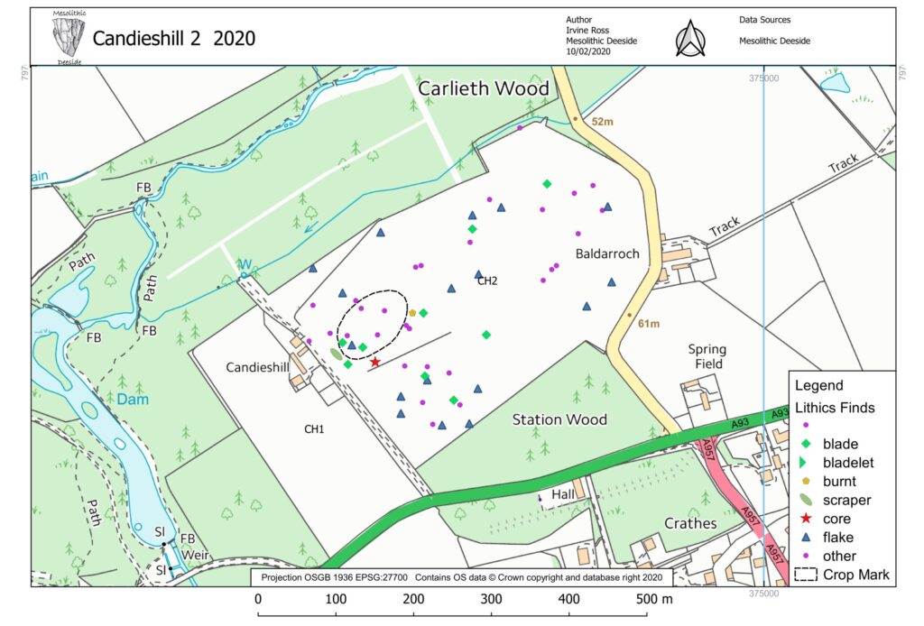
An example of the distribution plots that can be produced with the information from fieldwalking (Image credit: Mesolithic Deeside)
Join In
Fieldwalking is exciting and fun and a real contribution to archaeology. Local groups can learn much about archaeology and the Stone Age in their area. By organising sessions with specialists such as a lithic specialist or palaeoenvironmentalist (someone who studies the landscape and vegetation of the past), it is possible to build up your knowledge about the early communities who lived in your region in the millennia immediately after the last Ice Age (as far back as 14,000 years ago). You will start to see the landscape in a totally different way!
Your local museum or Archaeology Scotland can help with finding local archaeology groups who are doing fieldwalking. More members are always welcome!
If you’d like to keep reading, dig into articles on Treasure Trove and finding Mesolithic sites in the Scottish mountains. For more information about existing projects, you can visit the websites of fieldwalking groups around Scotland, including Mesolithic Deeside, Tarradale Through Time, Stone Age Crathes, the University of the Highland and Islands Archaeology Institute, and Biggar Archaeology. Archaeological guidelines can be found on BAJR and the Chartered Institute for Archaeologists websites.

A selection of larger stone tools from the Mesolithic site on Rùm (Image credit: Caroline Wickham-Jones)
Discover more about lithic sites found across Scotland in this online guide from Historic Environment Scotland.
By Caroline Wickham-Jones, a freelance archaeologist who lived in Orkney and was the author of a popular archaeology blog. She was particularly interested in the first communities to visit Scotland at the end of the last Ice Age and had been working on a guidance document for the management and investigation of lithic scatter sites.
Header Image Credit: Mesolithic Deeside
![]()
This article was produced as part of Scotland Digs Digital. In the summer of 2020, we shone a spotlight on Scottish archaeology with the Scotland Digs Digital campaign which brought together online and offline events, as well as live updates from across the country for everyone to enjoy.
