What is Geophysical Survey?
Were you fascinated by x-ray glasses as a child? It’s a regular super-hero thing – to be able to look through walls, seeing in a different way to everyone else. Geophysical survey is a little bit like that – allowing us to see buried archaeological remains below the ground surface.
SEEING THE UNSEEN
Geophysics is a group of survey techniques, each of which uses specialised equipment to record the physical properties of the earth such as the earth’s magnetic field or the electrical fields emitted by metallic objects. And those properties vary depending on the type of remains beneath the soil, such as buried ditches or walls, or depending on whether a feature has been burned at one time.
Geophysical survey lets us look below the surface without disturbing the ground or buried archaeological remains. Normally the survey equipment is wheeled across, carried above or pressed into the surface to take readings, so no holes need to be dug, and no damage is left behind.
This work can be done both to search areas for previously unknown archaeological remains or to characterise areas of archaeological interest to try and answer specific research questions, such as those set out in the Scottish Archaeological Research Framework. It’s used by commercial archaeology companies, public bodies such as Historic Environment Scotland (HES), and community and special interest groups. The aims of a survey will inform the choice of approach, so ‘survey design’ is important.
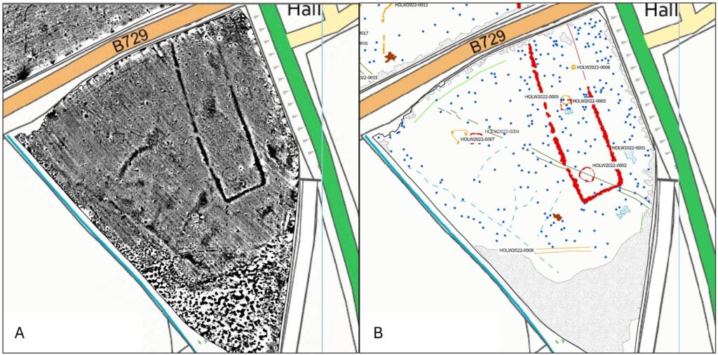
Figure 1 – Holywood South Cursus (A) north of Dumfries. Interpretation of the processed gradiometer data (B) (© Historic Environment Scotland)
TYPES OF GEOPHYSICAL SURVEY
The most used geophysical survey techniques are gradiometry, earth resistance and ground penetrating radar (GPR), which are described below. Each technique has strengths and weaknesses, so choosing the most suitable approach is important. Often, multiple techniques are applied as the different results can complement each other to provide a fuller picture of what lies beneath the ground.
Data needs to be processed using specialist software to visualise the results, which is normally a greyscale image (like the one shown above left) that displays the data as shades of grey.
However, these plots are basically a view of the data, and it’s important that the data is interpreted archaeologically to provide users with an indication of the types of features, usually referred to as anomalies, evident in the data. This mapping is shown as a graphic interpretation usually produced in a Geographic Information System (GIS) (see above right).
For example, from 2023 to 2025 as part of the Discovering Roman Inveresk project, HES used a range of geophysical survey techniques to investigate the extent of the Roman vicus (a civilian settlement) dating to the 2nd century AD (around 1,850 years ago) which lies to the east of Inveresk Roman Fort in Lewisvale Park in East Lothian.
The resulting greyscale image below added more detail to the remains of a Mithraeum (a temple dedicated to the Roman god Mithras) which was first identified by AOC Archaeology during a watching brief in 2010. It also revealed new features, including a roman aqueduct (the straight black line running east-west) and a different Romano-British temple (the double square towards the south).
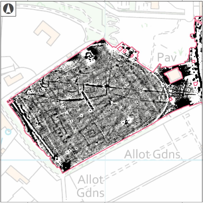
Figure 2 – Processed gradiometer data from Lewisvale Park, Inveresk showing a range of Roman archaeology (© Historic Environment Scotland)
GRADIOMETRY
Gradiometry is the most commonly used type of geophysical survey as the cart-mounted sensor systems used for this type of survey allow large areas to be covered.
The technique normally measures variations (or anomalies) in the earth’s magnetic field, which emanates from the core of the planet like the magnetic field produced by a magnet. These variations can be produced by buried archaeological features such as pits and ditches.
So too, buried ferrous (iron) objects have their own magnetic field which can be identified, while areas where burning has taken place, like in hearths, ovens and kilns, also produces strong signatures in the data. As stated above, all the data benefits being interpreted archaeologically rather than just relying on the greyscale plots (like the one shown above).
While gradiometry is normally a reliable method for detecting archaeological features, some types of geology such as igneous bedrock have such a strong magnetic field of its own that it overwhelms the archaeology – it creates too much noise!
The same is true of lightning strikes, which produce rough star-shaped anomalies that mask out any other potential features for centuries after the initial strike. There can also be problems if there are lots of modern iron material in the area, such as fencing or utilities as these interfere with the equipment.
Traditionally this type of survey was undertaken using hand-held equipment containing one or two sensors – set in a frame which looks a bit like a small rugby goal post. This requires measured grids to be laid out, which is time consuming.
But more recently the equipment has developed to a cart system (like the one shown below) which can carry up to 18 sensors and uses GPS to position the readings – so no need to lay out grids! The carts can be pushed by hand or towed behind a vehicle systematically covering the survey area – increasing the size of areas that can be covered, and the resolution. Areas over 20 hectares can now be surveyed in a single day – which is roughly 28 football pitches.
In June 2026, Historic Environment Scotland announced that they had discovered a possible new stone or timber circle through gradiometry conducted at Machrie Moor on Arainn (Arran). The archaeologists (led by this article’s author, Dr Nick Hannon FSAScot) discovered twelve circular pit-like anomalies. When the twelve spots are connected together, they form a circle with additional spacing for two more settings. There are no stones present in the pits, so the circle could have consisted of either stone or timber posts.
While the gradiometry carts do allow large areas to be covered, they do not work well on rough ground, which is where the smaller, slower handheld kit is still an advantage. Archaeologists are also experimenting with sensors mounted on Unmanned Aerial Vehicles or drones, which has promise, and may be another significant development on what geophysics can do.
This technique is best used in larger open areas for prospection purposes where the archaeology is defined by ditches.
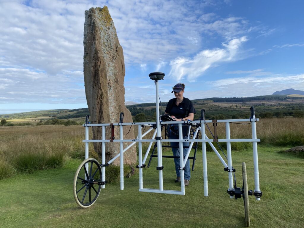
Figure 3 – A gradiometer cart system which may have uncovered a new stone circle at Machrie Moor Stone Circles on Arran in 2026 (© Historic Environment Scotland)
EARTH RESISTANCE
Earth resistance is commonly used by archaeologists in Scotland, but relies on measured grids, making it labour intensive and therefore suitable for use in smaller areas.
This technique measures the relative resistance of the ground by passing a small electric current through it. This is achieved by inserting metal probes mounted on a frame a couple of centimetres into the ground and then passing an electric current between them and recording the results.
The varying levels of resistance (how quickly or slowly the current travels between the probes) can show areas of archaeological interest especially when their moisture content varies – with buried pits and ditches tending to hold more moisture than the surrounding ground so showing lower levels of resistance, and buried walls and floor surfaces tending to exhibit higher resistance (as shown below).
In 2025, volunteers and HES archaeologists conducted an earth resistance survey at the medieval remains of Crookston Castle in Glasgow. Their work revealed five roundhouses and a palisaded (fenced) enclosure dating to the Bronze Age of Iron Age (over 1,600 years ago), the first time that evidence of prehistoric occupation at the site had been found. These roundhouses were identified as rings of low resistance caused by the moisture retained in their ring ditches.
This technique can be difficult to use in rocky areas or areas with thick undergrowth. Particularly dry or very wet conditions can impact how well the technique works, as those conditions influence how the electrical current travels through the ground.
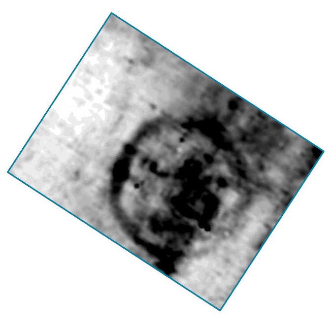
Figure 4– Processed earth resistance data from Crookston Castle showing a palisaded (fenced) enclosure to the south-east of the castle (© Historic Environment Scotland)
GROUND PENETRATING RADAR (GPR)
GPR is a more recent addition to the suite of geophysical survey techniques.
This kit emits pulses of radar energy from an antenna and records the reflected signals. If the pulse hits solid objects, voids or boundaries between different types of materials, a bit of the signal is reflected to the source. This allows the depth of the archaeological deposits to be estimated by determining how quickly the energy passes through the ground and then recording the time the signal takes to return to the antenna.
In this way, GPR is a 3D technique allowing the location and depth of buried features to be recorded. The results are normally displayed as a series of ‘timeslices’ showing different depths through the ground profile (see below).
GPR was also used as part of the Discovering Roman Inveresk project. Since most of the vicus lays beneath the modern town, a survey was undertaken in the back garden of a private house just across the road from the ancient Roman bath house, which revealed an 1,850-year-old building that had once been part of the vicus (see below).
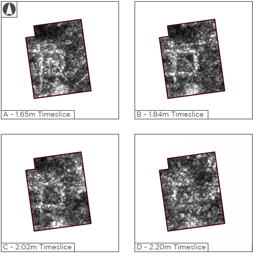
Figure 5 – GPR timeslices showing a Roman structure at Inveresk – revealing what are probably solid floors (© Historic Environment Scotland)
Both single and multiple antennae equipment is available for GPR. Single antenna equipment (as shown in the image below) is used for small area surveys, either mounted on a small cart or on a sled to allow it to be pushed or dragged along the ground. Multiple antennae equipment is normally mounted on a vehicle and allows larger areas to be surveyed at a higher resolution in a relatively short period of time. In both cases, the position of each reading is recorded using GPS.
The equipment needs to be in direct contact with the ground, so it’s difficult to use on rocky ground or areas with lots of undergrowth, so ideally the survey area should be smooth and flat. This is also easier on the person operating the equipment! This technique is best suited to sites where there are buried structural remains and we want to know how deep they are.
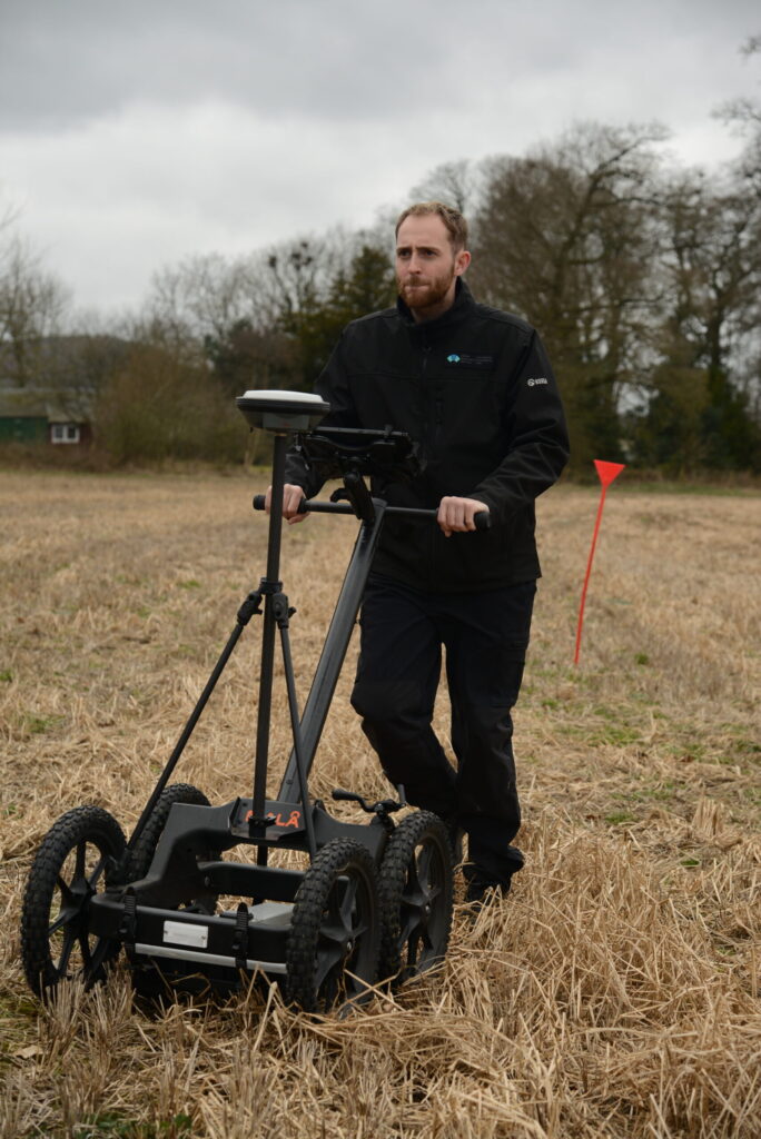
Figure 6 – A single antenna GPR being use at Carpow Roman Fortress in Fife to better understand the ditches relating to the temporary camps; the GPR was used to see the profiles (V-shaped or U-shaped) of the ditches and their depth (© Historic Environment Scotland)
WANT TO FIND OUT MORE?
Geophysical survey is a powerful suite of techniques that allow archaeologists to see belowground features and remains without having to dig it up. Alongside other archaeological survey techniques, geophysics is helping us to better understand Scotland’s historic environment.
If you’re thinking of carrying out a geophysical survey, permission must be given by the landowner and if the site has legal protection, such as a scheduled monument or Site of Special Scientific Interest, then additional permissions may be needed. If you want to find out more, check out the European Archaeological Council’s guidelines.
By Dr Nick Hannon FSAScot. Dr Hannon is an archaeologist specialising in the use of remote sensing techniques to investigate archaeological landscapes. He works at Historic Environment Scotland as Senior Heritage Recording Manager leading the organisations geophysical survey programme. His interests include geophysical survey and Roman frontier archaeology.
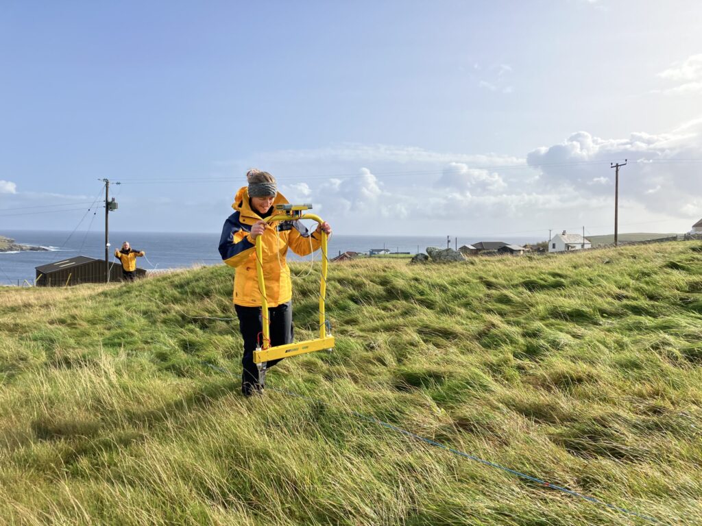
Header Image: An earth resistance meter being used at Dunrossness on Shetland (© Historic Environment Scotland)
