How Drones are Helping to Save Scotland’s Coastal Archaeology

Climate change is everywhere and affecting everyone. Recent extreme weather events ranging from droughts and heatwaves to dramatic floods have shown the extent of the threat. We can still prevent some of the worst impacts by changing our behaviour and reducing our emissions, but our coastlines are set to experience some of the most dramatic effects of climate change.
However, archaeologists have a plan to prevent the loss of our spectacular archaeological sites by the sea.
WHAT’S HAPPENING TO OUR COASTAL HERITAGE?
As the second longest coastline in Europe, Scotland’s shores are dramatic and varied. Some of the country’s most fertile land is often at the coast and for millennia the sea has offered access to resources, as well as opportunities for transport and communication, so it has always been an attractive place to live.
This means that thousands of archaeological sites are now threatened by coastal impacts of climate change, such as accelerated erosion, flooding or complete submergence by rising seas. Around the coast, sites of all periods are being lost to the waves. Important archaeological evidence is being washed away by storms and high tides before we can learn from it – and the problem is going to get worse. But there are things that can be done to offset this loss.
WHAT HAS BEEN DONE TO SAVE COASTAL ARCHAEOLOGICAL SITES?
Some sites have already been protected by sea walls, such as the 5,000-year-old settlement of Skara Brae, which was first exposed by a storm in 1850 but is now a very popular tourist attraction where visitors can learn about Neolithic life in Orkney.
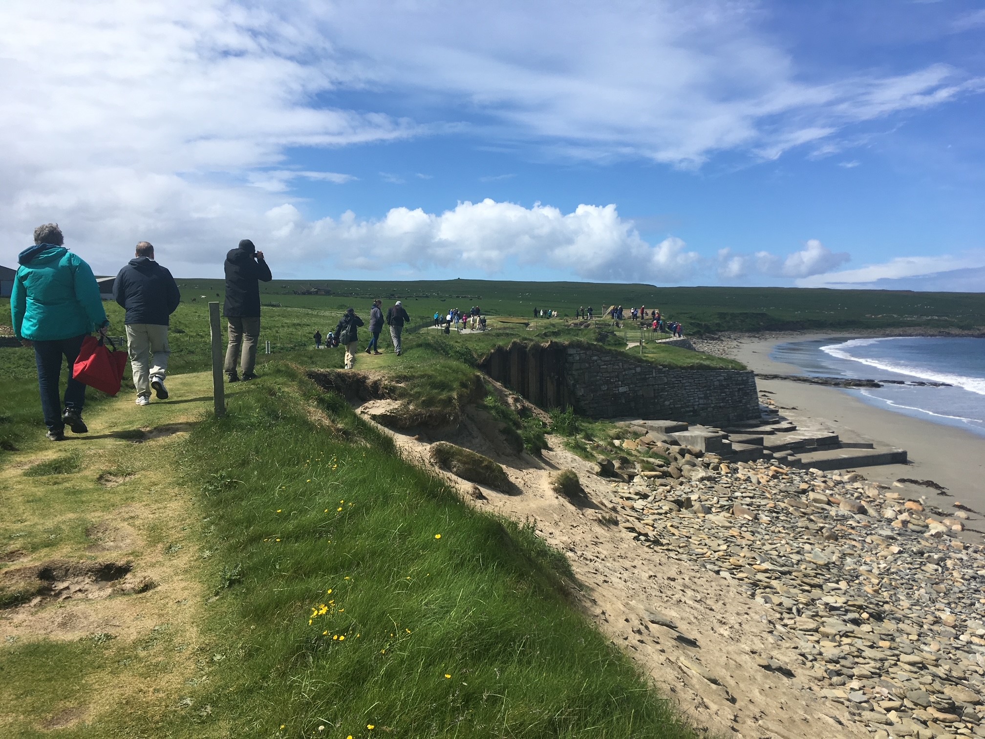
Skara Brae is now a popular visitor attraction in Orkney, but its vulnerable location means it has to be protected by a sea wall to stop erosion destroying this Neolithic village (© Ellie Graham)
Others such as Meur Burnt Mound in Sanday, Orkney have been investigated to rescue information and valuable knowledge about the past before the evidence is destroyed by erosion – a method known as ‘preservation by record’. This Bronze Age structure was also relocated stone by stone and reconstructed at Sanday Heritage Centre as a permanent feature and tourist attraction.
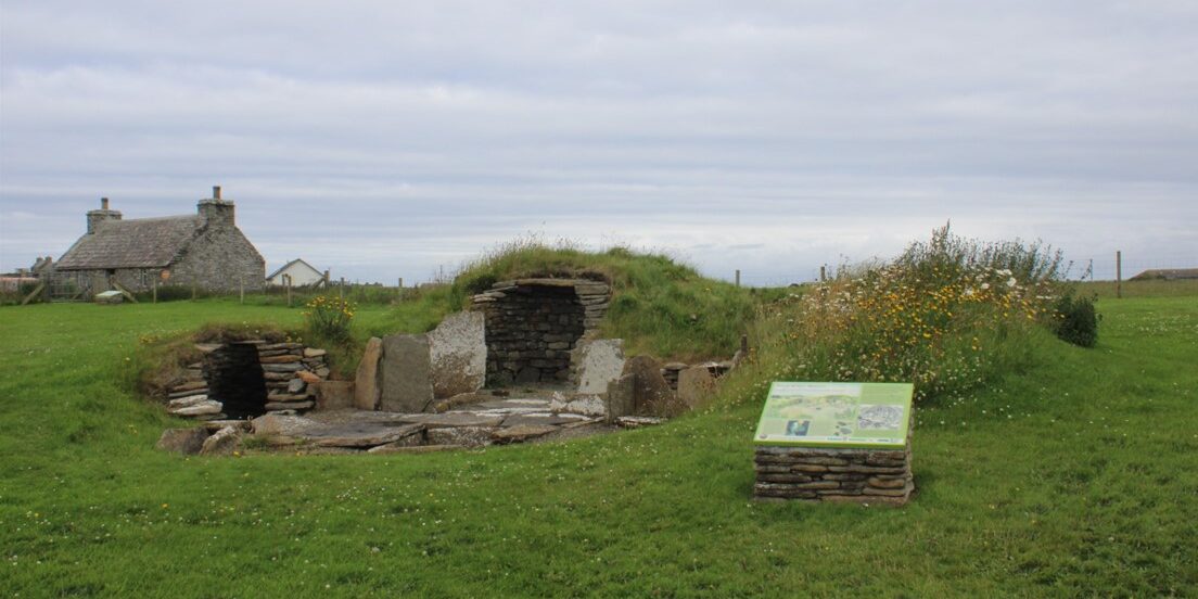
The reconstructed burnt mound structures were originally on the beach where they were being damaged by every storm, but have now been moved and rebuilt at Sanday Heritage Centre where visitors can learn about Bronze Age life in Orkney (© Ellie Graham)
However, these options are expensive and can be difficult to carry out. There are simply more threatened sites around Scotland than we can preserve or completely excavate, and in many cases we don’t know anything about the sites we’re losing. A recent coastal heritage survey project by the team at Scotland’s Coastal Archaeology and the Problem of Erosion (SCAPE) which worked with local volunteers from around the coast highlighted 145 sites which are important, vulnerable and valued by the local community.
So how do we catch up?
TURNING TO TECHNOLOGY TO PRESERVE OUR COASTAL HERITAGE
With their ability to take aerial photos for accurate birds’-eye views, drones are an exciting emerging tool that archaeologists can use to help understand sites and landscapes. With enough overlapping overhead images, a technique called Structure from Motion can also be used to build millimeter-accurate 3D digital models of heritage sites.
Archaeologists are using this approach to record sites, and specialists such as myself are applying this technique to survey and map some of the most significant and threatened coastal sites around Scotland. The resulting digital models will help us understand the sites better, monitor their current condition and record the exact location of the current coast edge.
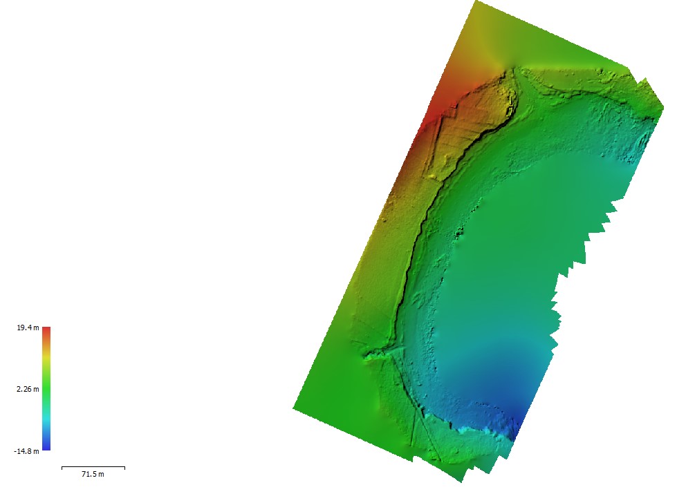
This digital 3D was model created from drone photographs, recording a coastal landscape in Shetland where archaeological sites from the Iron Age to the Second World War are being destroyed by erosion (© Ellie Graham)
But as well as recording the past, this technique can help predict the future of these sites. The models can be used as the basis for comparison with old maps, records and photos, to work out how much land we’re losing to erosion and how much more we could lose.
Historic weather records can help work out the impacts of specific storms and project those losses into the future to work out how vulnerable these sites are – and potentially how long we have before they’re lost altogether. Hopefully this can help us to decide where to prioritise research for investigation – so we can rescue archaeological information before it’s lost.
I’m looking at sites all over Scotland, from the Borders to Shetland and in all types of coastal landscapes, from soft sand dunes to rocky cliffs. We’ll learn more about these specific sites and how vulnerable they are, but in addition, these locations and erosion trends have been closely observed– so changes we record here can be used to understand coastal erosion and vulnerability more widely across the country.
LEARNING FROM THE PAST – THE IRON AGE SETTLEMENT AT BAILE SEAR (BALESHARE), UIBHIST A TUATH (NORTH UIST)
One example is Baile Sear, an extensive Iron Age settlement on the west coast of Uibhist a Tuath, in the sandy machair landscape which is exposed to the wild weather of the North Atlantic.
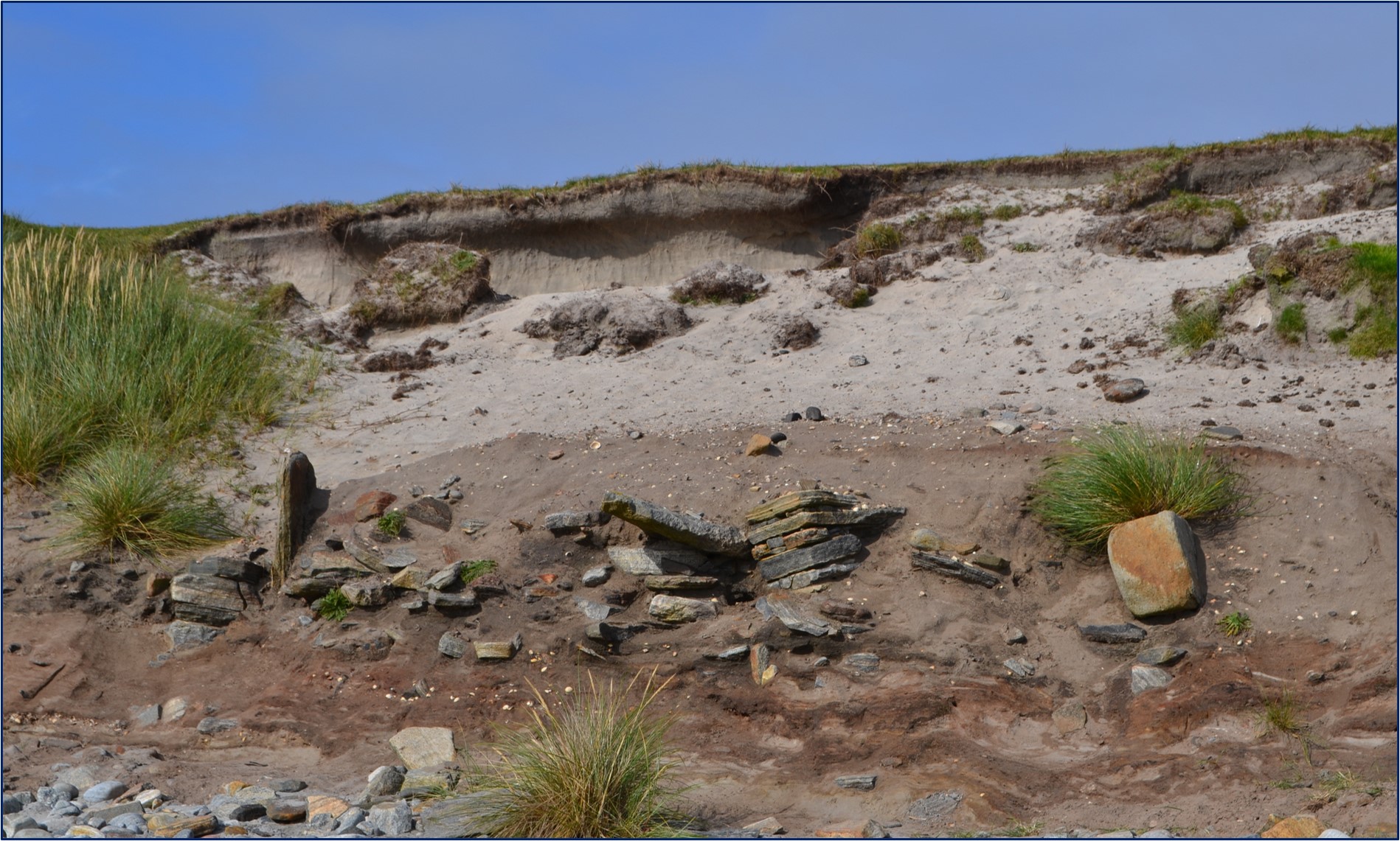
Stone structures, probably an Iron Age wheelhouse eroding out of the sand dunes at Teanna Mhachair at Baile Sear (Credit: SCAPE)
Previous archaeological excavations here have revealed several wheelhouses (drystone roundhouses with a series of short walls around the interior perimeter giving the structure the look of a wheel with “spokes”) and occupation spanning hundreds of years, but the eroding face of the sand dunes along the beach show many more stone structures and evidence of the everyday lives of past peoples.
More wheelhouses at the site of Teanna Mhachair and deep deposits of midden (a historic rubbish heap) – containing animal bone, charcoal, pottery and other artefacts – at Ceardach Ruadh are falling out of the coast edge. Comparison of a drone survey from 2018 with one from autumn 2021 shows that up to 10m of land has been lost here in less than four years – and if we project those rates forward to 2050, nearly 100m of this buried archaeological landscape could be lost to the sea.
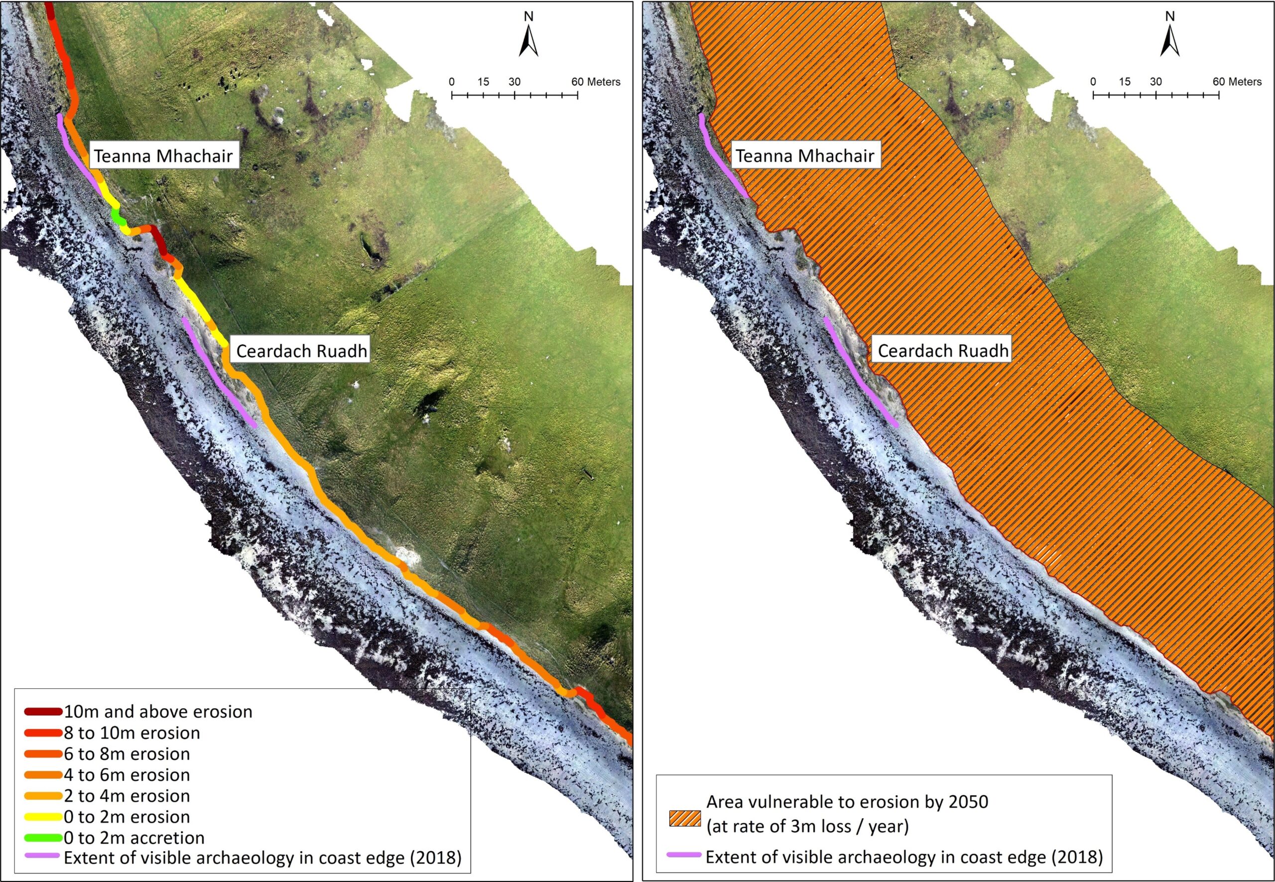
Comparing the modern survey with past records showed how much land has been lost in the past few years, and how much more we could lose by 2050 (© Ellie Graham)
LEARNING FROM THE PAST – ST MONANS SALT PANS, FIFE
Another very different site I’ve been surveying is a group of late 18th century salt pans at St Monans in Fife, where locally-mined coal was once used to boil seawater to create salt. This is a much younger and well-documented site with historical records telling us when it was in use. When the salt pan houses were built, they were on the coast to take advantage of the proximity to sea water. The original builders however, were not expecting them to be destroyed by the sea, so coastal defences have had to be built here to protect the land on which the site sits.
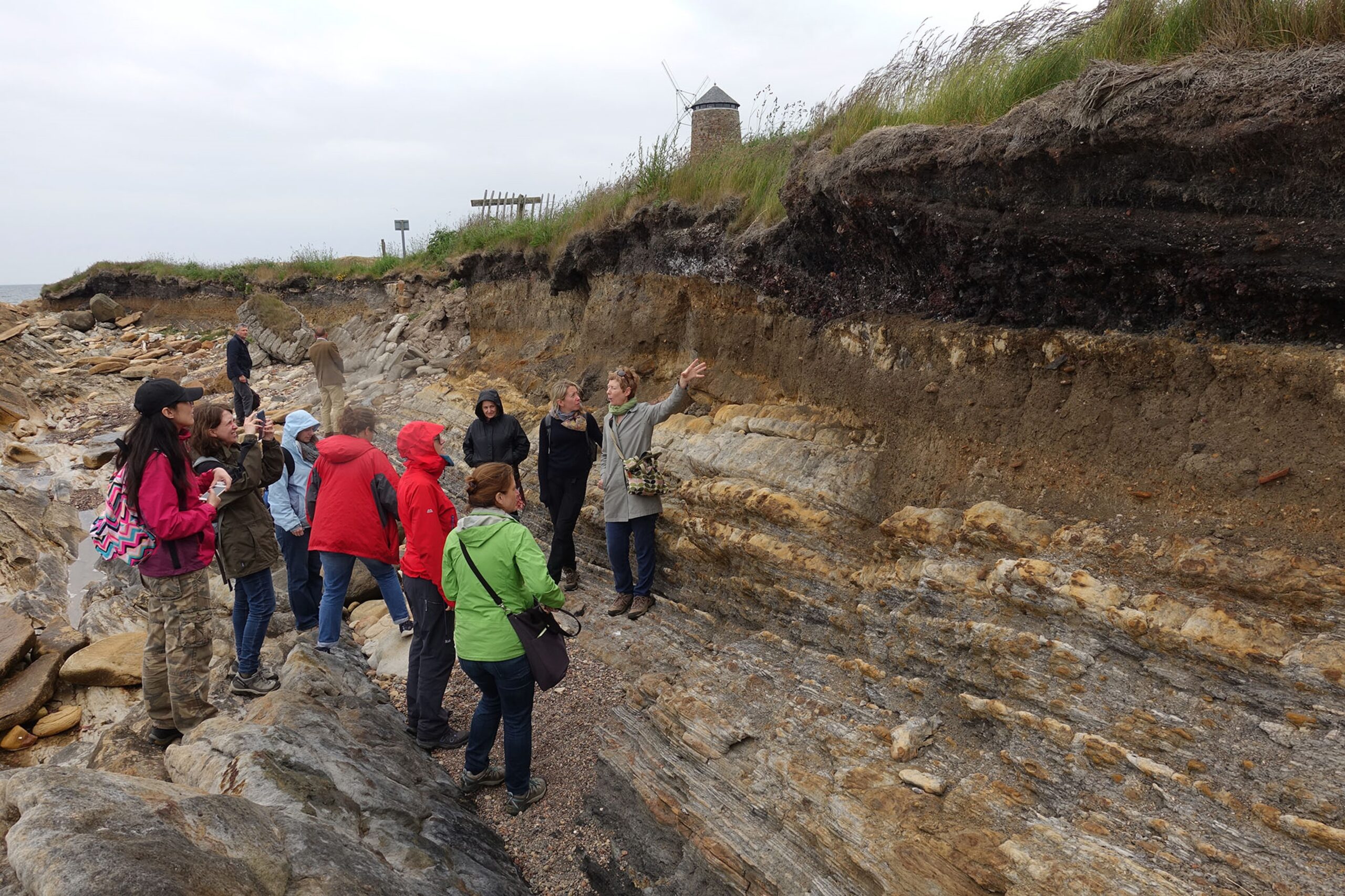
Archaeological deposits associated with the salt pans are visible in the eroding coast edge (Credit: Bill Lees)
Anyone walking along the coastal path can’t miss the signs of erosion, the concrete wall of the coastal defence has collapsed in places, while the path has been diverted to avoid the dangerous eroding coast edge. The coastline here is low lying but rocky, and in the more sheltered Forth estuary, conditions are very different compared to the machair dunes of the Outer Hebrides.
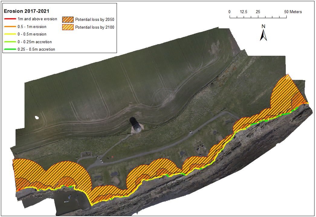
Comparison between a photomosaic map of the coastline at St Monans in 2021 and a model from 2017 showed that in places over 1m of land has been lost, and how much more could erode by 2050 and 2100 (© Ellie Graham)
However, a similar analysis and comparison of drone surveys from 2017 and 2022 showed that although erosion here is slower, it’s still a significant threat. Stretches of this coast have eroded by over 1m in four years, and in places those rates of loss would mean 10m of land could be eroded by 2050 – which would be enough to almost completely destroy some of the historic panhouses.
WHAT DOES THE FUTURE HOLD?
There are many more important and threatened archaeological sites around Scotland that we don’t yet know anything about. Part of my project also aims to understand these sites better to inform our knowledge of what we’re losing and how quickly.
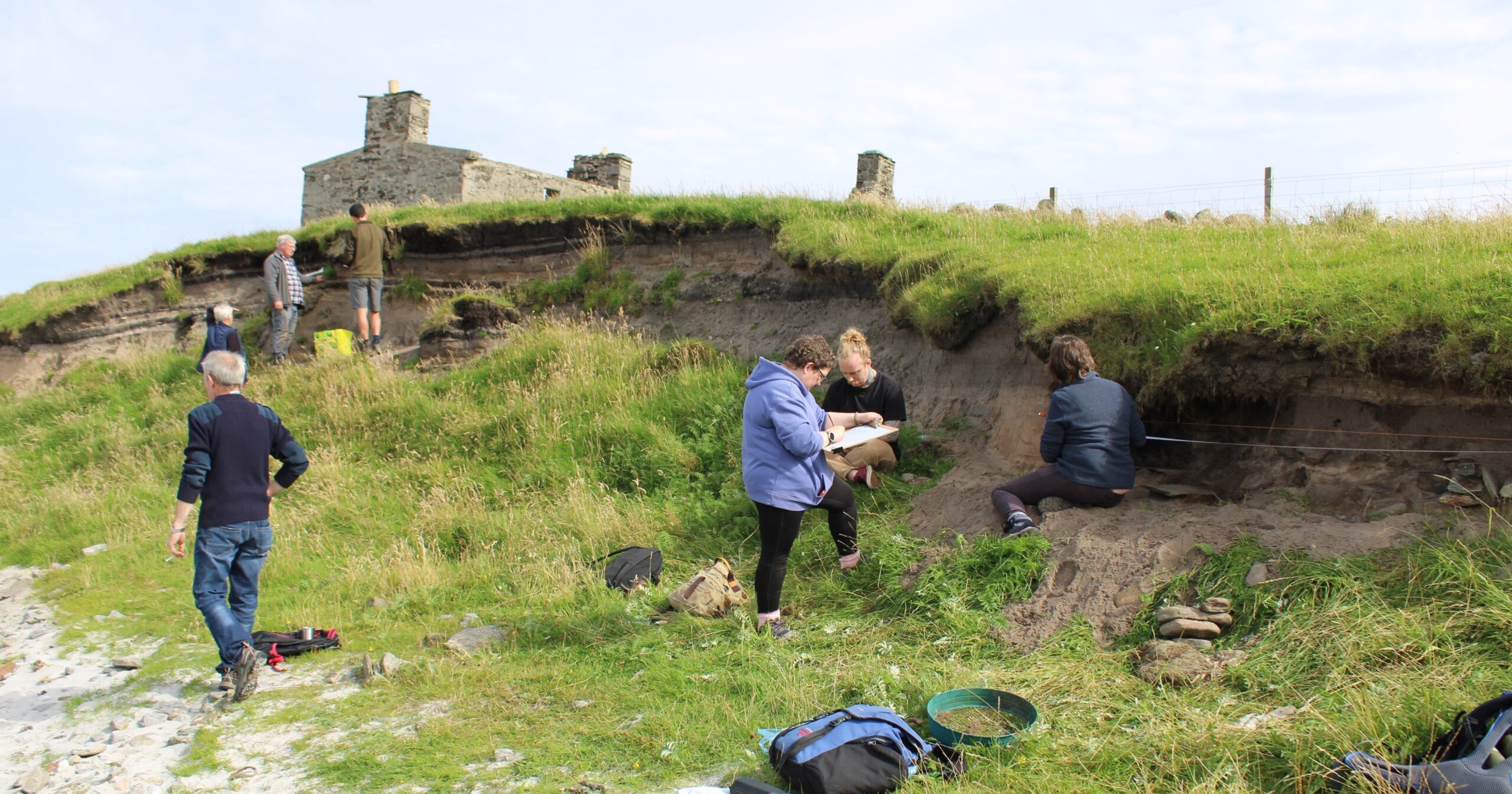
Volunteers from Archaeology Shetland recording one of the sites we investigated on Yell in August 2022 (© Ellie Graham)
In August 2022 I spent two weeks working with local community members volunteering with Archaeology Shetland. Together we investigated several archaeological sites and acquired dating information to better understand when the sites were in use, so that we can then show how and when the coast might have changed in the past.
These investigations yielded some unexpected and exciting results, and rescued valuable archaeological information that was literally falling out of the coast edge and could have been washed away on the next high tide. An article on the Archaeology Shetland website will tell you more about some of the highlights and discoveries we made.
By Ellie Graham, an archaeologist and PhD researcher at the University of Aberdeen, who is using drones to survey eroding coastal sites around Scotland. Ellie previously worked with the SCAPE Trust doing similar work on eroding sites with local volunteers. If you’d like to get involved in recording our vulnerable coastal heritage, SCAPE are carrying out surveys of parts of the Moray Firth and Aberdeenshire.
Header Image: Drones are a very useful tool for archaeologists to get a birds eye view of sites (Credit: Marc Chivers)
