Beyond Walls: Exploring Roman and Iron Age Encounters in Northern Britain through Archaeology
Over 1,900 years ago, the outermost edge of the Roman Empire was a place of complex relationships between occupying forces and local communities. Interactions in places like northern Britain ranged from trade, exchange and collaboration to open conflict and resistance.
What do we know about the Roman Iron Age in Scotland?
The Romans built two frontiers in Britain, Hadrian’s Wall in what is now England and the Antonine Wall in Scotland. There is also, evidence for the Roman presence during the first few centuries AD in the roads, camps, forts, and signal stations that have been found across the landscapes of northern England and southern Scotland. And the evidence for the local communities that lived in these areas include hundreds of both enclosed and open settlements.
But despite years of study, many questions remain about how the Roman and local populations interacted during the Late Iron Age (also known as the Roman Iron Age), and how that varied over time and from area to area. These questions include:
– Did people live in the same settlement patterns as they did before the arrival of the Romans or did the presence of the Roman army have a major influence?
– Do certain types of sites appear or disappear during this time or do existing ones (such as enclosures, crannogs, brochs) change?
– Can the archaeological evidence give us clues to how the societies and communities in our study area compare to other Roman frontier areas?
– To what extent did the Late Iron Age society and economy change when interacting with the Roman army?
How are researchers investigating this period?
To address these questions, the Leverhulme-funded project Beyond Walls: Reassessing Iron Age and Roman Encounters in Northern Britain (2021–2024) is aiming to explore how people used and settled the land before, during, and after the period of direct Roman presence in the region. This is roughly from 500 BC to AD 500, or between 2,500 and 1,500 years ago.

Figure 1: The project area covers northern England and southern Scotland, with four case study areas selected for detailed study.
Throughout the project, the team aim to emphasise the complex nature of the relationships between Roman occupiers and indigenous communities, which will feed into wider discussions about encounters at the edges of imperial powers. But first, they’ll need to compare broad patterns across the entire study area (see Figure 1) with local trends and explore the impact that humans had on the landscape using three approaches which include:
1. Carrying out targeted landscape surveys
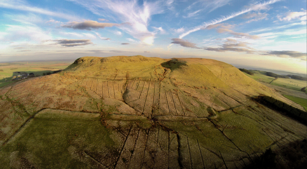
In 2021, a pilot study for this project was carried out with support of the British Academy in an area in Dumfries and Galloway around Burnswark Hill, a well-known hillfort flanked by two Roman camps where hundreds of Roman projectiles (specifically, lead sling shot) have been recovered.
The pilot project produced a database of all known settlement evidence and used high-resolution LiDAR (a laser scanning technique which you can learn more about here) data to identify 134 previously unknown Iron Age settlements (Figure 2). This increased the number of known sites to a total of 704 definite, probable, or possible Iron Age settlements in a c.1500km2 area.
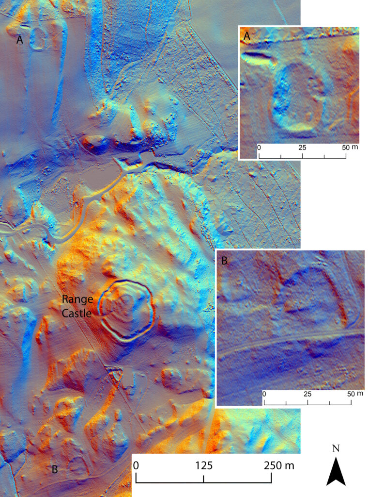
Figure 2: Example of two Iron Age enclosures (A and B) recently discovered through LiDAR-based survey in the vicinity of Range Castle
Many of the newly identified sites were probably small farmsteads, which are important because most of the indigenous population would have lived in such settlements.
2. Producing new radiocarbon dates
They’ll also be producing about 300 new radiocarbon dates that will help improve the dating of excavated settlement sites and palaeoenvironmental sequences (reconstructions of the environment through time based on the preserved remains of organisms such as plants). For settlement sites of interest, they’re using site archives to identify archaeological contexts (e.g. features such as hearths or postholes) which are likely to help answer questions about the chronology of a site (when events occurred there).
The samples are then retrieved from the physical excavation archives (usually held in museums) for radiocarbon dating, along with any information about stratigraphy and phasing information about the order in which the events the samples represent happened. The team use this information to inform the chronological models they are producing as part of the project. So far, they’ve dated samples from two sites in Dumfries and Galloway: the multi-phase site of Carronbridge near Thornhill which includes a Roman camp and indigenous Iron Age settlement evidence, and the enclosed settlement site of Woodend near Moffat.

Figure 3: A peat core taken from a bog near Thornhill, Dumfries & Galloway.
3. Analysing new and existing palaeoenvironmental data
As well as looking at patterns in the settlement record, the team are also interested in exploring changes in the wider landscape. Reconstructing past environments through analysis of pollen preserved in peat deposits is helping to answer questions about farming and land use.
During this research, they’ll be carrying out pollen-based palaeoenvironmental reconstruction at sites across our case-study areas, both at new, unstudied sites, and at sites where pollen records exist, but are perhaps not well-dated enough to help answer their research questions. So far, they’ve taken samples from Burnfoothill Moss and a site in the hills near Thornhill, both in Dumfries and Galloway, and from Moat Knowe in the Scottish Borders.
The first step is to take a peat core using a corer to extract a column of peat (see Figure 3). The team can date samples from different depths in the peat and use these dates to construct an age-depth model for the core, providing them with an estimated age for a sample from any given point in the core.
The next step is extraction and analysis of pollen preserved in the peat cores. Pollen grains from different plant species can be distinguished from each other based on characteristics such as shape, size, and surface texture.
Using a microscope, they count pollen grains extracted from samples from various depths in the core and then use the proportions of different species and types of plants to recreate what the environment may have looked like in the past. Combining this data with chronological information from an age-depth model allows the team to reconstruct landscapes at given points in the past.
Telling the story of Rome’s northern frontier
These techniques will allow the team to explore settlement patterns, land use, and interactions between Roman and indigenous populations on the Empire’s northern frontier.
While they can’t answer every question, they hope to fill in a few blanks in this story and provide a platform for future research in the region, including discussions about the nature of Roman imperialism and its impact on frontier societies.
Want to explore the Iron Age further? Check out Dig It!’s list of top sites and discoveries from Iron Age Scotland.
By Sophie McDonald FSAScot, Manuel Fernández-Götz FSAScot, Dave Cowley FSAScot, Derek Hamilton FSAScot, and Ian Hardwick FSAScot.
Dr Sophie McDonald FSAScot – researcher at the Scottish Universities Environmental Research Centre (SUERC), University of Glasgow. She is an environmental archaeologist with interests in land use, settlement, and chronology.
Prof Manuel Fernández-Götz FSAScot – Abercromby Professor of Archaeology at the University of Edinburgh. His main research interests are Iron Age and Roman societies in Europe, the archaeology of identities, and conflict archaeology.
Dr Dave Cowley FSAScot – archaeologist at Historic Environment Scotland with interests in landscape survey, remote sensing, and later prehistoric settlement.
Prof Derek Hamilton FSAScot – Professor of Archaeological Science at the University of Glasgow’s Scottish Universities Environmental Research Centre (SUERC). His main research interests lie in Iron Age societies in NW Europe and the application of isotopic methods for understanding such things as diet and mobility within refined temporal frameworks.
Dr Ian Hardwick FSAScot – researcher at the University of Edinburgh with interests in landscape, frontier, and identity, specialising in Iron Age and Roman settlement and landscapes across northern Britain.
Text adapted from: Fernández-Götz, M., Cowley, D., Hamilton, D., Hardwick, I.J. and McDonald, S. 2022. Beyond Walls: Reassessing Iron Age and Roman Encounters in Northern Britain, Antiquity 96(388), pp. 1021–1029.
