What are Archaeological Desk-Based Assessments and What Have They Uncovered in Scotland?
Archaeology doesn’t begin when the shovel hits the ground. Indeed, it’s possible to study historic features in the landscape without even kneeling down! Lachlan McKeggie, Director of Highland Archaeological Services, lifts the lid on one form of archaeological investigation – desk-based assessments.
What Is a Desk-Based Assessment?
A desk-based assessment (DBA) is an investigation carried out before any project involving archaeology begins. This might be a research project (where a researcher is trying to answer a question like ‘is this feature a Pictish fort’) or a commercial project like a new housing estate, new road or new pipeline.
It involves reviewing existing records and maps to see if there might be any important historic remains at or close to the site. This helps to give some basic background to a site, the sort of activity that’s going on in the vicinity and give clues as to the sort of things we might expect to find during any site work.
Highland Archaeology Services carry out around 25 DBAs a year. We’re usually helping the organisation who is building something to deal with the archaeology conditions of their planning permission (what the local council say you need to do to be allowed to build), which means we need to produce a good level of work without taking too long or going too far.
For example, it’s often tempting to dive off down a rabbit hole and chase the history of a family or the methodology of an antiquarian – but the art of the DBA is getting as much useful background information as possible without it taking six months. This is best achieved by knowing the Scottish sources (most of which are also available for the public to browse) and using them well.
How Do Archaeologists Look for Potential Sites?
The Historic Environment Record (HER)
For archaeologists in Scotland, the best place to start when investigating a site are the historic environment records. As well as looking to see what features are recorded at the location you’re interested in, it’s always worth looking at the land nearby so you’re getting an idea of the terrain you may end up visiting. For example, is the site you’re interested in half-way up a mountain or by the sea?
Pastmap is the national record for sites in Scotland. Using the filters, users can turn on and off different types of record and see how many sites have been recorded in that part of the country. There are some things archaeologists carrying out a DBA will need to bear in mind when using Pastmap, though:
1) The local records may be better. While the national Pastmap covers the whole of Scotland and lists most records of archaeological sites, the ‘local’ HERs sometimes have more (this is particularly the case in Highlands, which has a fantastic HER that you can explore).
2) Just because there are no archaeological sites recorded on the map doesn’t mean that there isn’t anything there. Finding new things is the best bit of archaeology!
3) Keep in mind, you may need to expand or refine your search. In some places a few hundred metres is enough (particularly in a town where the buildings around are going to tell the story) but in a rural area you might end up looking up to 10km away. The archaeologist’s aim is to get a rounded picture of the landscape in a sensible timeframe.
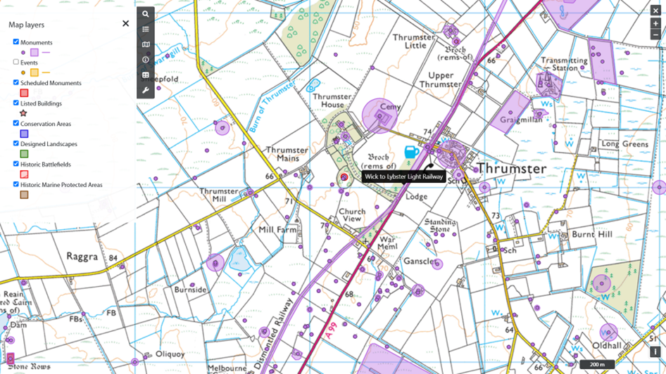
Figure 1: Screenshot from the Highland Historic Environment Record
Maps and Aerial pictures
After a look at the HER, it’s time to head over to the National Library of Scotland (NLS) to take a look at their maps. In the past, archaeologists might have had to physically travel to the NLS building in Edinburgh to see the maps, but luckily for us (and for you at home) many of the most useful maps are now digitised and available online.
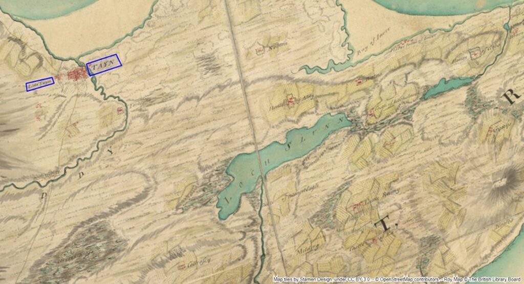
Roy’s Military Survey of Scotland (made in the mid 1700’s) is always a good place to start. This map was compiled under the supervision of Major-General William Roy following the Jacobite Risings and is the first map to cover the whole of mainland Scotland in detail.
Like any source though, you do have to keep its limitations in mind and recognise that human error has crept in. The whole town of ‘Tayn’ (Tain) in the Highlands, for example, appears to have been drawn on the wrong orientation. Despite these issues, Roy’s map is fantastic for seeing towns, large houses, and roads and what they were called at the time the map was drawn. The first edition Ordnance Survey (OS) map made in the mid to late 1800’s is also invaluable as it covers both the whole of the UK (with the Isles as well) and was created with a much higher level of detail.

Figure 2: Section from 1st edition OS map Caithness, VI.10 (Olrig) Surveyed in 1872
Once you’ve consulted the maps, you can bring your perspective up to date with a brief look at aerial pictures from any online source such as Google or Bing. This lets you see known features but also sometimes spot new ones. This can be good in more rural or hard-to-reach areas like these two unrecorded huts we noted in the Corie Na Ba near Ciseorn (Kishorn) in the north-west Highlands.
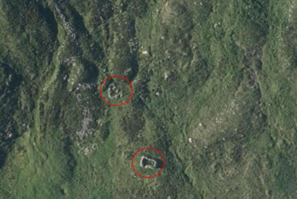
Figure 3: Aerial picture showing two structures from Bing Maps (c) 2022
You can now even look at LiDAR (landscape-wide laser scanning) data which is particularly useful for heathery or forested areas as the LiDAR picture effectively removes the trees and heather and lets you see the ground surface beneath.
The Name Book
The Name Book should really be as famous as the first edition OS map. It was created by OS map makers during the mid-1800s and records the names they would eventually put on the map with a description of what the thing or place was like at the time. It also lists the owner and who gave them the information.
This is a fantastic resource if you have a placename on the first edition OS map that you want to know about, and particularly useful if your Gaelic language skills aren’t too good and you want to know what the place name means.
Sometimes you also find a gem in the Name Book like the fabulous sketch below of a cist that the cartographer has drawn from a description he was given. From the description, it seems the local MP dug up a Bronze Age cist burial in the parish of Wick about five years before the entry was written. The cist would have been made with stone slabs and may have been crouched (where the body is laid on its side with knees drawn up).
The nameless Victorian map maker has done his best to depict what he thinks a skeleton in a stone box would have looked like. It’s a lovely piece of history depicting the discoveries of early archaeologists, but probably not very accurate!

Figure 4: Entry from the Name Book (OS1/7/13/21 1871-3).
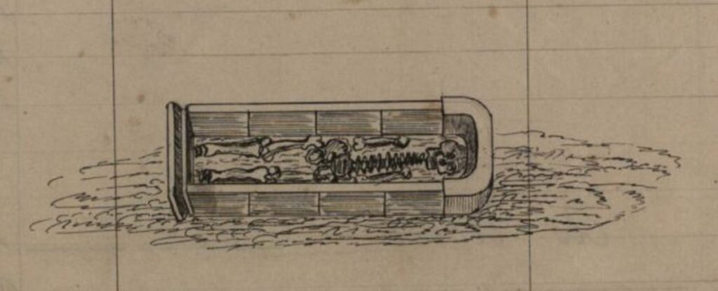
Figure 5: Sketch of a cist from the Name Book (OS1/7/13/21 1871-3).
The Old and New Statistical Accounts
The ‘Old’ Statistical Account (1791-99) and the ‘New’ Statistical Account (1834-45) are collections of reports from ministers from the Church of Scotland giving information on their parishes. These are generally viewed as among the best contemporary reports of life during the agricultural and industrial revolutions, from the 17th century through to the late 19th century. They offer uniquely rich and detailed parish reports for the whole of Scotland, covering a vast range of topics including agriculture, education, trades, religion and social customs.
When I first started reading the statistical accounts when carrying out DBAs, I didn’t see the value of them. They do occasionally have a section on antiquities and mention things like the famous castles in a parish, but the references are all a bit vague and often full of out-of-date thinking. For example, the entry on the Nigg Stone, records the stone as a memorial to three shipwrecked Danish princes when it’s actually a Pictish cross.
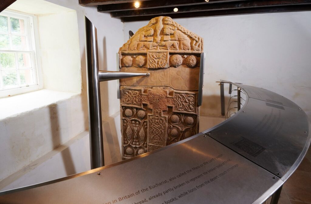
Figure 6: Nigg Stone (Photo Credit: Ewen Wotherspoon for the Highland Pictish Trail)
However, over the years, I have come to realise the accounts are an invaluable source for understanding the social conditions in a parish at the time the account was written. Was the population growing or shrinking? Who were the main employers? What sort of houses were people living in? Like any historic document they need to be looked on with a little scepticism, but there are valuable insights we can mine from them.
Geology
Hopping over to the British Geological Survey (BGS) Geology Viewer helps archaeologists gain an understanding of the composition of any site. Although you may not have even noticed while looking at your other sources, a striking connection can often be seen between the geology and the layout of sites.
For example, in the Highlands, this often links to patches of lime which produce better growing conditions and where you’ll find the only farmstead in miles of open hillside. A good example can be found south of Reay on the north coast in the Highlands, where the small and isolated Achvarasdal Township sits on a patch of Gunnscroft Limestone.
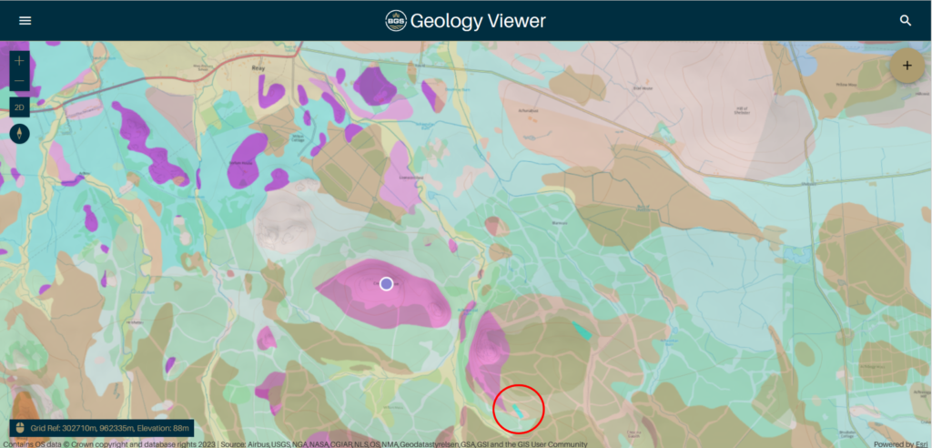
Figure 7 – The red circle marks the location of the township, and the tiny rectangle of light blue indicating limestone as shown on the Geology Viewer
Digging Deeper
DBAs are an essential part of the archaeological process and collating all the information to complete one can be very worthwhile. The well-established sources listed above have almost certainly told you a good deal about your site, but there may be more details to find from other sources. A great deal of time could be wasted chasing down dead ends, but sometimes a little extra searching can bring up something very interesting.
For example, in 2023 Highland Archaeology Services undertook a DBA ahead of an extension planned on a house in the Highlands. We noted in the HER that the village the house was in had been built up under the patronage of a particular family in the second half of the 19th century, and we learned from the Name Book that this family owned many of the named buildings in the village. The record for the village in the HER noted that the family were ‘popular and benevolent’ and clearly very wealthy.
A short investigation and a little local background knowledge led us to the Centre for the Study of the Legacies of British Slavery database, where I found that a portion of the family’s wealth was derived from slave holdings and estates in Grenada, British Guiana, Tobago and Antigua. This family had used the wealth they’d built up from the labour of enslaved people to build back home, thus benefiting both themselves but also the community along the Great Glen. Suddenly, the story of our ‘popular and benevolent’ family became much more complicated. (If you’d like to know more about the relationship between the Highlands and slavery, take a look at the book ‘Slaves and Highlanders’ by David Alston or download his self-guided walk of Inverness free here).
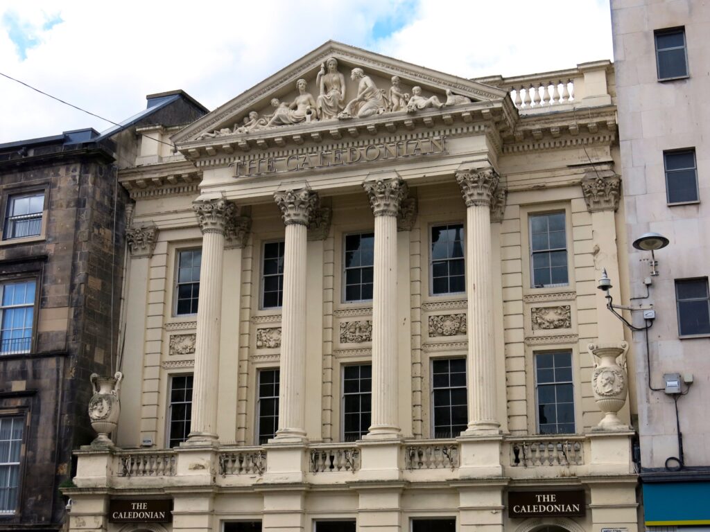
Figure 8: There are many buildings in the Highlands, such as the Old Caledonian Bank in Inverness, that are linked to historic wealthy plantation-owning Scottish families or which were constructed directly using profits from enslaved labour (© Enric via WikiCommons, CC BY-SA 4.0)
Drawing It All Together
The DBA is not a particularly well-known aspect of the archaeological process as it’s not always as exciting as digging and doesn’t produce exciting pictures like geophysics does, but it’s a necessary part of archaeological practice. No fieldwork by a professional unit should be undertaken without one and this makes the fundamental sources listed above very important.
As an individual or heritage group, the most important thing you can do to help enhance the understanding of your area is add information to the Historic Environment Record. This resource should always be looked at ahead of work – even a photograph and a note of what ’s there and what it looks like can be a huge help. In the Highlands, you can do this though the HER website or for other parts of Scotland take a look at Canmore.
By Lachlan McKeggie, Director of Highland Archaeology Services. Lachlan is based on the Black Isle in the Highlands where he was also brought up. He is a graduate of Glasgow University and has worked for a number of organisations including Historic Environment Scotland, Archaeology Scotland and Archaeology for Communities in the Highlands. He has a particular love for community archaeology and walkover survey; When he’s not enthusing about old things to people he can often be found wondering the side of a hill with a GPS and some ranging poles.
Highland Archaeology Services is a small independent archaeology company based in the Highlands of Scotland. It specialises in the archaeology of Northern Scotland and undertakes both commercial and community work across the area. It was established in 2004 and is the only Chartered Institute for Archaeologists (CIfA) Registered Organisation with its headquarters in the Highlands.
Header Image: Roy Military Survey of Scotland, 1747-55. CC-BY (BL)
