Top Six Archaeological Sites on Scottish Islands to Photograph
The sheer breadth and wealth of archaeology on Scotland’s islands is incredible, with evidence from every period of human interaction represented on our islands. From Mesolithic shell middens right up to Second World War defences and everything in between.
My focus for any trip to a new island will be archaeological sites and the more photogenic, the better. I have visited most of Scotland’s islands that are connected with public transport, from Unst in Shetland, to Hirta (St Kilda) in the North Atlantic, to Giogha (Gigha) in Na h-Eileanan A-Staigh (Inner Hebrides).
Here’s my personal list of archaeological sites that I have been lucky to visit and photograph with my trusty smart phone over the years.
Knap of Howar, Orkney
The ferry hopping required to get here from the mainland is worth the travel. The Knap of Howar consists of two ‘houses’ with surviving stone cupboards and stalls.
They date back to the fourth millennium BC (over 5,000 years ago) – contemporary with Orkney chambered tombs. The two houses are the best preserved and most visible early Neolithic settlement anywhere in north-western Europe.
Standing inside these ancient homes and admiring the view out to sea, I can’t help but imagine what daily life was like in these buildings thousands of years ago. The level of preservation is outstanding and the site’s relative remoteness means you can sometimes have the place all to yourself.
Excavated by Dr Anna Ritchie HonFSAScot in 1973 and 1975, she found evidence that a farming community lived here in the later fourth millennium BC (around 5,000 years ago) who may have been the makers of Unstan ware pottery. The report from these excavations is available to read free online in the Proceedings of the Society of Antiquaries of Scotland.
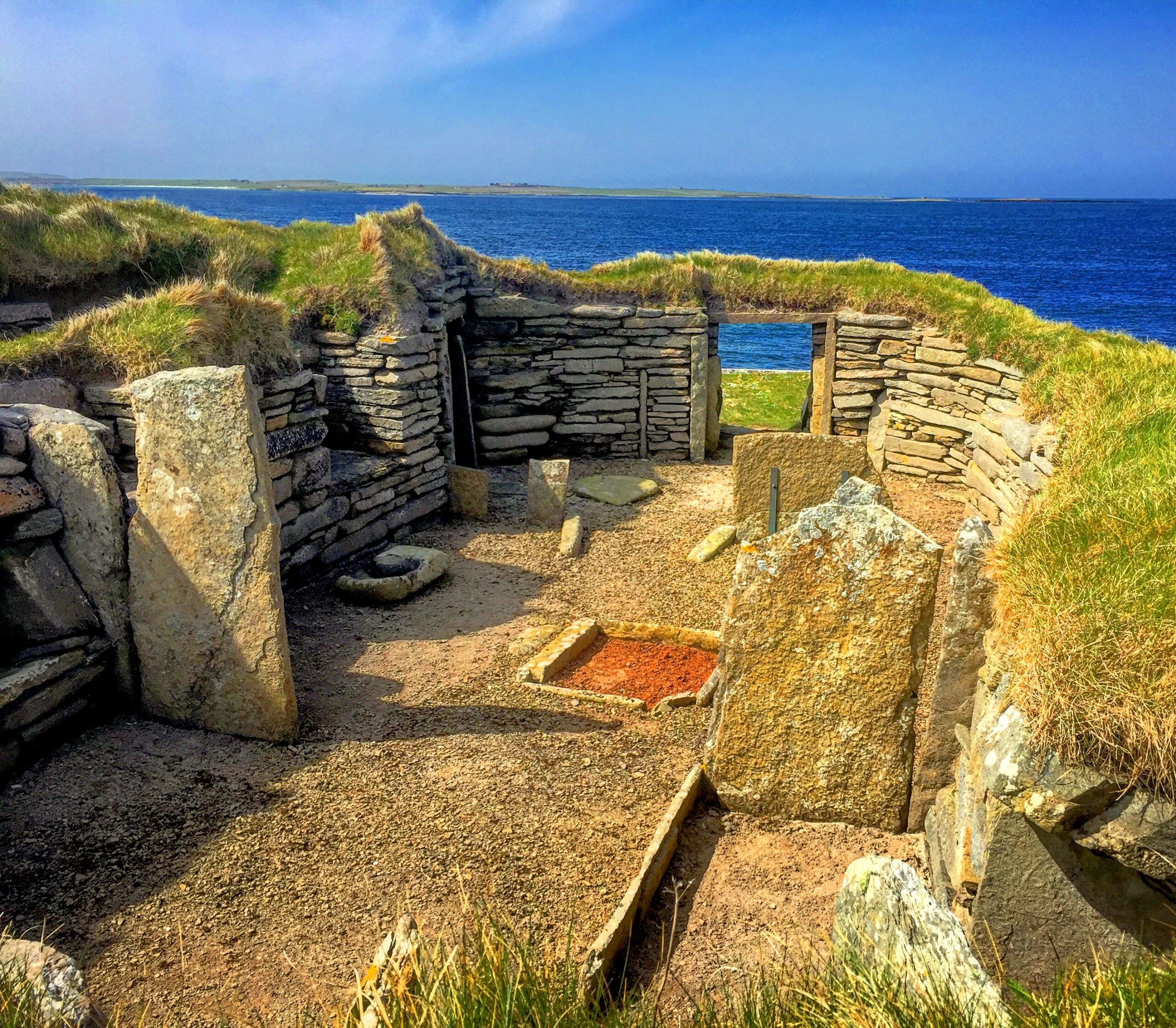
Kanp of Howar (© Kyle Armstrong)
Finlaggan, Ìle (Islay)
Islands often require some additional effort and planning to visit from the mainland, but there are locations on them which were once considered to literally be the centre of the world to their past inhabitants.
Finlaggan is a remarkable collection of sites located on a loch on Ìle (Islay). The site consists of three islands, with Eilean Mòr (the Large Island) and Eilean na Comhairle (the Council Island) containing the remains of buildings.
Here the inauguration (a formal ceremony or event) of the MacDonald Lords of the Isles took place. The Lords of the Isles were descended from Somerled, a 12th-century “prince” and Finlaggan was their home and the centre of their Lordship.
The Lords of the Isles ruled mainland Argyll and the Glens of Antrim in Northern Ireland. The heir to a strong Gaelic and Norse tradition, the Lord of the Isles was one of the most powerful figures in the country, with the tiny islands in Loch Finlaggan serving as the very centre of symbolic and administrative importance. Miniscule dots on a map, but once the epicentre of control over a vast and powerful territory.
You can find out more about what excavations have uncovered here in this Dig It! article, and in The Archaeology of Finlaggan, Islay, published by the Society of Antiquaries of Scotland (who coordinate Dig It!), which is available to read as a free e-book.
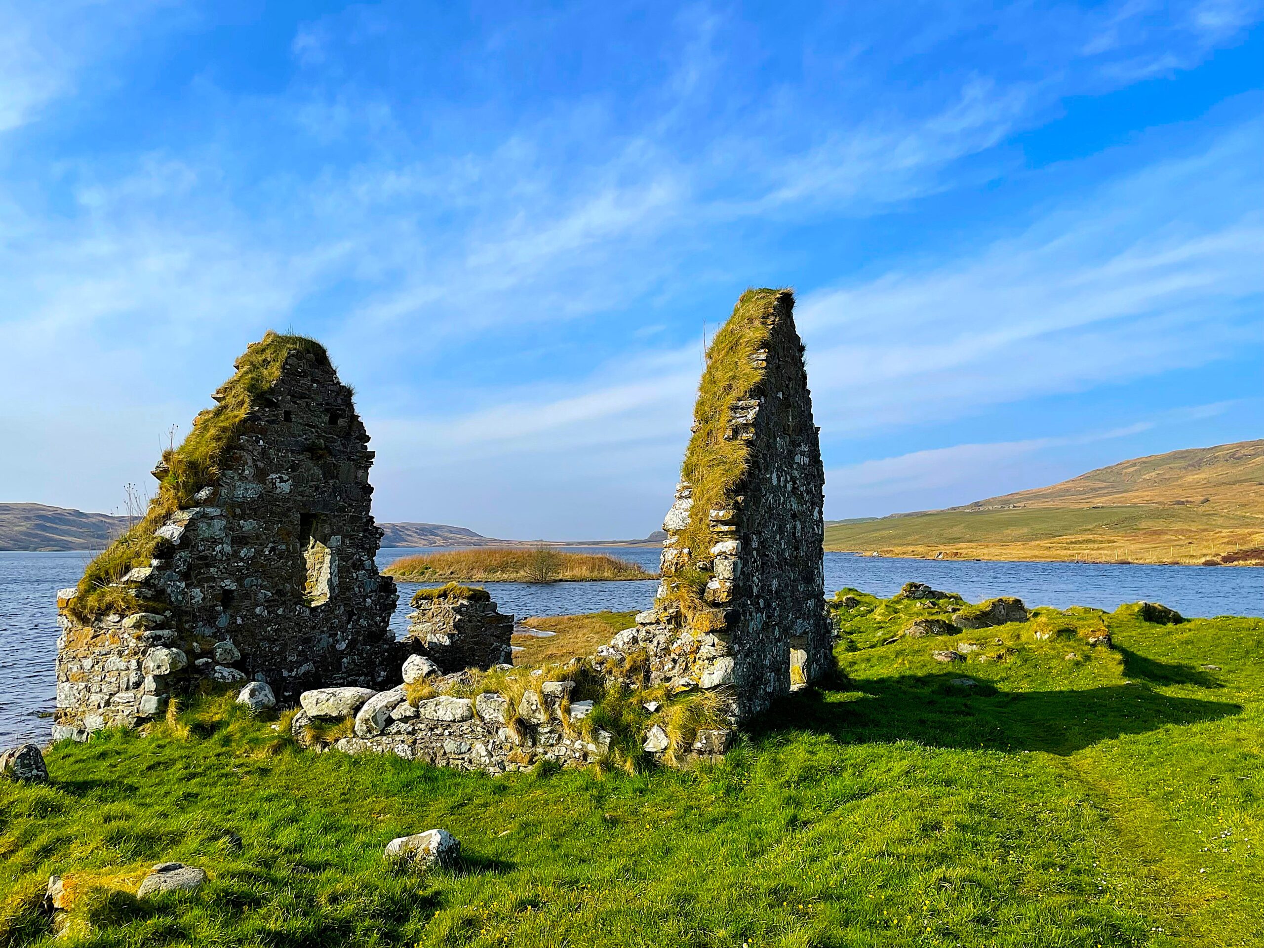
Finlaggan (© Kyle Armstrong)
Gylen Castle, Cearara (Kerrera)
Ruins have long captured the focus of artists, photographers and landscape designers, with some even purposefully created for their romantic aesthetic (what we call “follies”). Many of Scotland’s ruins still epitomise this picturesque ideal and Gylen Castle on the southern shores of the island of Cearara (Kerrera) is one of the most picture-perfect ruins in the country.
It had a relatively short life; built in AD 1582, the castle was besieged then burned by the Covenanters (members of a 17th-century Scottish religious and political movement, who supported a Presbyterian Church of Scotland) in AD 1647.
In 2002, a full topographic and geophysical survey was carried out by GUARD to investigate the nature and history of the monument in its landscape. These surveys showed that structures which may pre-date the existing 1580s tower house are still present beneath the surface and could be of interest to future archaeologists.
In recent decades, the castle has undergone extensive conservation work to stabilise the ruin, jointly funded by Historic Scotland and the Clan MacDougall. Monitoring and limited excavation work at the time of repairs has revealed evidence for the siege of 1647, for example revealing fire-damaged interior stonework. And in 2005, a watching brief recorded a mid-17th century copper coin with the letters ‘NEMO’ and part of a thistle visible which dates to the same time as the 1647 destruction date.
What’s left of Gylen Castle is an inspiring ruin that, with careful recent conservation, always manages to look effortlessly beautiful through the camera lens.
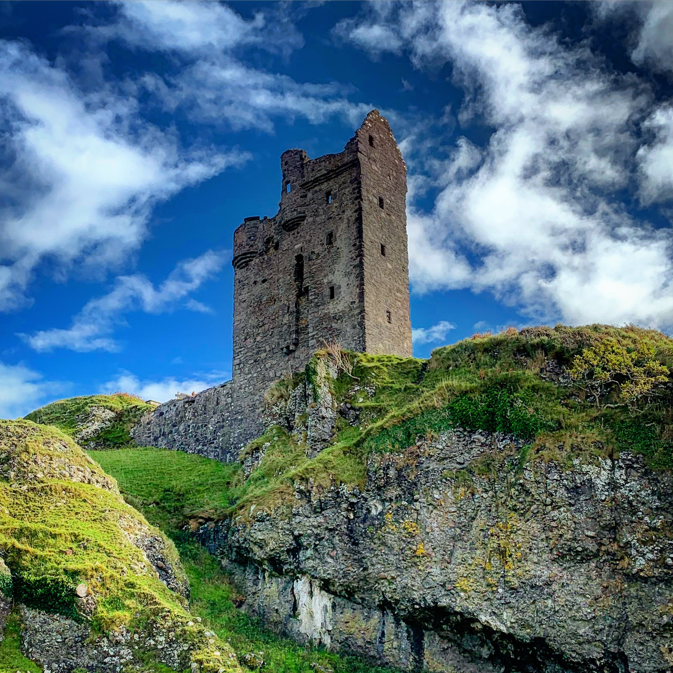
Gylen Castle (© Kyle Armstrong)
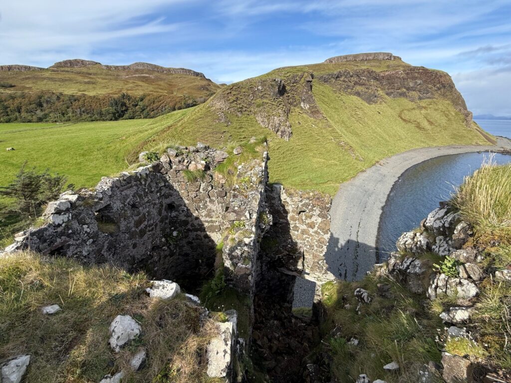
Coroghan Castle, Canaigh (Canna)
The Small Isles is an archipelago found in Na h-Eileanan A-Staigh accessible by ferry from Mallaig on the west coast of the Highlands. Taking the tiny passenger ferry over is an experience in itself as you pass the rising, cragged Rum Cuillins and the sloping Sgurr of Eigg with its hilltop fort.
Approaching Canaigh (Canna), the most distant of these islands, reveals a prominent rock stack on the coast. Perched on this stack is Coroghan Castle, a tiny fortification clinging on top of the near 25-metre-high stack. You need a head for heights and steady feet to get up and into this castle.
According to local tradition the building was a prison, used in the late 17th century by a jealous husband to confine his wife (said to be Donald MacDonald of Clanranald and his wife Marion MacLeod). However, it’s more likely that it was built as a defensive structure that turned the stack into a well-defended position. Indeed, records indicate a “refuge” on the rock from AD 1577-95 and the small gatehouse and tower was probably constructed around then or shortly after.
While to date there haven’t been any excavations or stray finds at the site, the castle is a great example of how archaeological surveys (of various kinds) are important in helping us uncover and record the material remains of Scotland’s past.
For example, the castle was recorded in 1994 as part of the RCAHMS National Archaeology Survey: Canna. Then in 2018, aerial photography and innovative mapping technologies allowed the National Trust for Scotland to generate 3D ‘digital twins’ of important heritage and archaeological sites on the island, helping to build immersive virtual tours to explore Canna online – you can view the map here.
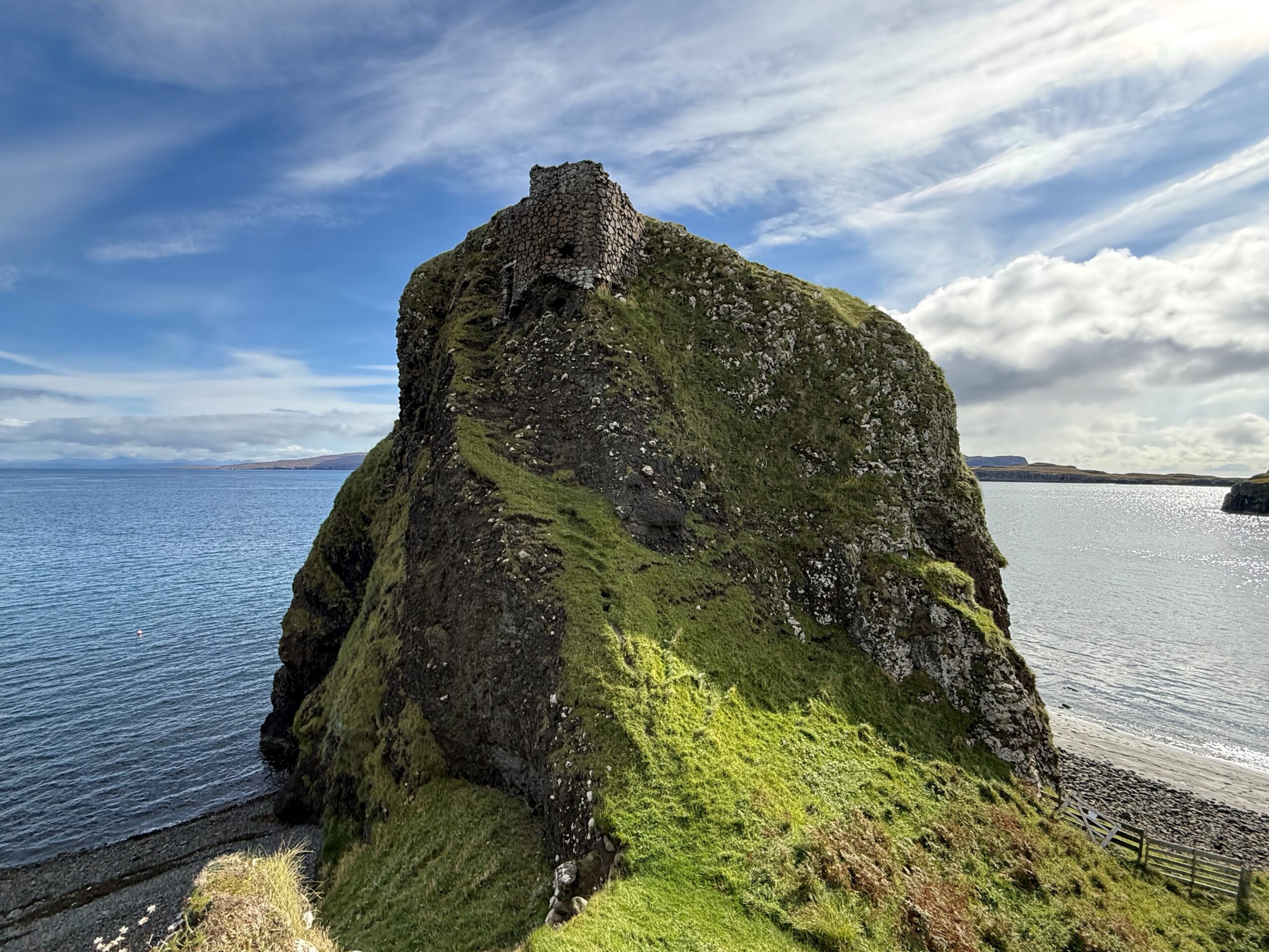
Coroghan Castle (© Kyle Armstrong)
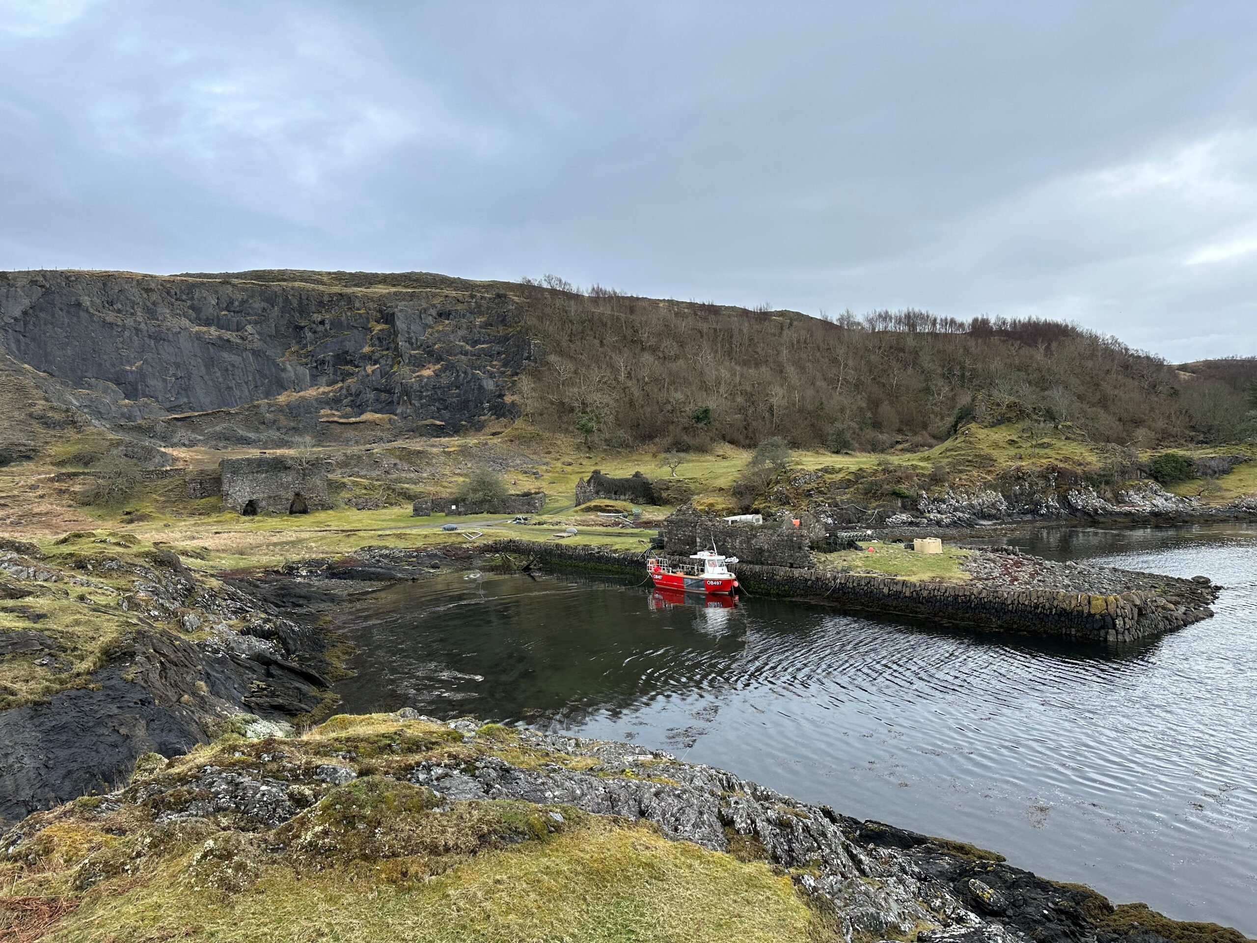
An Sailean Lime works, Lios Mòr (Lismore)
The remains of Scotland’s industrial past can be found all over the Scottish islands and one of the most prominent are the remnants of the lime industry. An Sailean on the island of Lios Mòr (Lismore) was one of the last major lime works to operate from Scotland’s islands.
Lime works were a lucrative business in the 19th century and offered crucial employment to labourers. They were the source of a vital product for both industrial and agricultural Scotland.
Burning limestone, which is calcium carbonate, produces calcium oxide. Mixed with water, this produces slaked lime – calcium hydroxide. It was key to the agricultural revolution which helped feed the growing and more centralised populations.
Lime was also necessary for the development of Scotland’s towns, cities and infrastructure as it was a key component in mortars and plasters. It was also used in numerous industries such as steel making. An Sailean was the largest lime works on the island and the last to operate, only closing down in the 1930s.
The site is now a quiet spot. The buildings are abandoned and stand as a silent reminder of its industrial past. Thanks to some rare archive material in the form of photographs taken by Erskine Beveridge in 1883, we don’t need our imagination to envisage the site operating. A small collection of his photographs show the lime works in full operation and even with a boat in at the jetty – possibly loading up on barrel of slaked lime to trade on the mainland.
The site has also been subject to detailed recording work including scale drawings and plans by archaeologists Drs Colin and Paula Martin FSAScot, which can be viewed online.
Visible today are the lime kilns, limestone quarry, managers’ house with office, coal store with yard, associated workers’ cottages, explosives store, and a quay with shop and cottage, adjacent to ballast dumps from ships. It isn’t hard to stand among the ruins and imagine this industrial hub at its late 19th -century peak.
An Sailean Lime works (© Kyle Armstrong)
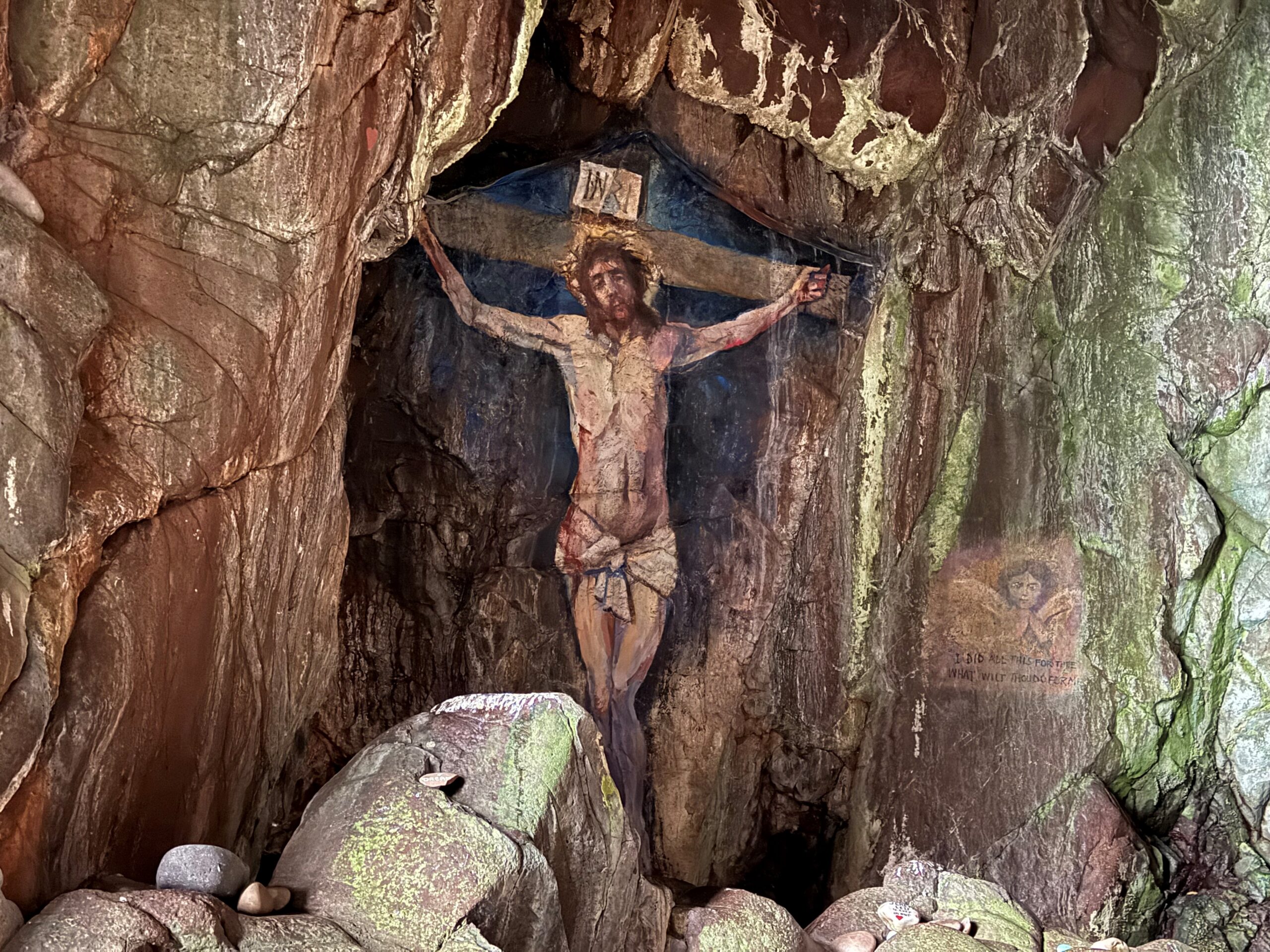
Crucifixion Cave, Davaar Island
Caves have been places of human interaction for thousands of years, whether as prehistoric seasonal shelters, possible sacred spaces adorned with Pictish carvings or as even as documented 20th-century homes for some travelling people. They are intriguing spaces and continue to capture our attention into the present day.
Crucifixion Cave on Davaar Island in the Mull of Kintyre is a unique example of this. Arriving in nearby Campbeltown, you have to patiently wait for the tide to recede before making the long walk across the shingle to access the tidal island. A slippery, rocky trek around the coastal shelf is required, along with a keen eye, to spot and enter the cave.
Step into the narrow cave and when your eyes adjust to the light, a life-size cave painting depicting the Crucifixion appears on the left wall. First painted in AD 1887 by local artist Archibald MacKinnon after he had a vision in a dream suggesting that he do so.
Restored several times since, including twice by the original artist, the painting was vandalised in July 2006, having a red and black depiction of Che Guevara painted over the original masterpiece. It has since been carefully and authentically restored again.
The SCAPE Trust, who work with the public to research, investigate, interpret and promote the archaeology of Scotland’s coast, noted in their Coastal Zone Assessment Survey for Kintyre that, while there are currently no issues to the site from coastal erosion, the painting is vulnerable to deterioration caused by the coastal cave environment and will continue to be monitored.
It’s fascinating how this truly unique piece of cave art has continued to draw attention and focus, unfortunately some negative and damaging, which is testament to the power, draw and mystery of caves, even into modern times.
Crucifixion Cave, Davaar Island (© Kyle Armstrong)
Hopefully this collection of some of the special archaeological sites that lie on our islands provides you with some inspiration to explore. I am already thinking of my next island-bagging trip and making my way onto the CalMac website now.
By Kyle Armstrong MA Arch FSAScot. Kyle graduated with a MA in Archaeology from the University of Edinburgh and also studied Architectural History. First employed by the Royal Commission on the Ancient and Historical Monuments of Scotland with focus on archiving, research enquiries, copyright and licensing. Then moving onto working in the Scheduled Monuments team at Historic Scotland and most recently as Senior Designations Officer (Listing and Scheduling) at Historic Environment Scotland.
Header Image: Coroghan Castle © Kyle Armstrong
