Top Five Archaeological Sites in Stirling
Is Stirling the most important place in Scottish history? Stirling Council’s Archaeologist Dr Murray Cook FSAScot makes his case for the city and surrounding area.
Founded as a Royal Burgh in 1124, Stirling guards Scotland’s former frontier (between Pictland and Alba), is the home of tartan, and boasts the world’s oldest football and curling stone. It’s also home to one of Scotland’s greatest stone castles, one of its best medieval bridges and two of its most important battles (Stirling Bridge in 1297 and Bannockburn in 1314).
Furthermore, it’s the only place in Europe where you can easily travel from a medieval battlefield to the location of a Jacobite siege and then to the site of a coronation, as they’re all found within a 10-mile radius of each other.
Instead of focusing on some of the more famous sites such as Stirling Castle and the Battle of Bannockburn battlefield (which are worth a visit), here are some of Stirling’s more hidden archaeological gems with information largely based on Dr Cook’s research. If you’re keen to visit, they’re organised in a line so you can travel between each of them over a weekend.
Old Town Cemetery
Open 24/7, you can start your visit at the cemetery complex around Stirling Castle and the Church of the Holy Rude. The church sits next to Cowane’s Hospital, which was established in 1637. It’s the best-preserved medieval hospital in Scotland and acted as an element of the burgh wall.
Dr Cook has been digging on the site for the last few years with several volunteers which revealed both a previously unknown bastion (a projecting tower which allowed for defensive fire) and Stirling’s only surviving medieval gate through its 16th-century wall.
This wall was built during the Eight Years’ War to protect Mary, Queen of Scots when England attacked Scotland from 1543 to 1551, partly to force the Scottish Parliament to confirm the marriage alliance between Mary and the son of her great-uncle, King Henry VIII.
The gateway is a dog-leg-shaped passageway and the east-facing side (the side of Cowane’s Hospital) is covered in musket ball impacts from a later siege on the castle in 1651. Looking up at the church tower, every window has halos of musket ball impacts left behind from when people were trying to kill snipers in the church.
The fighting carried on through the cemetery and the second oldest gravestone has further musket ball impacts on both sides, making it some of the best evidence for historic street fighting in Scotland.
If you’re planning to visit, be sure to grab a copy of the cemetery tour leaflet from the church.
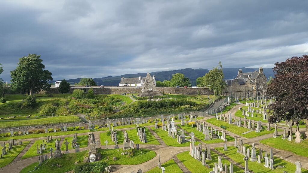
Stirling cemetery (Image credit: Dmso, CC BY-SA 4.0 <https://creativecommons.org/licenses/by-sa/4.0>, via Wikimedia Commons)
Mote Hill
Mote Hill is a wee hillfort which sits at the northern end of Kings Park, Stirling’s Royal Park (the oldest in Scotland). When Dr Cook dug here with volunteers, they found melted stone which had been vitrified when the fort was set on fire, possibly when it was destroyed around AD 100 (almost 2,000 years ago). This means that the timber-framed rampart of the fort was set alight with a fire that exceeded 1,000 degrees centigrade and was maintained for long enough to melt and fuse the stones.
Although there are a lot of vitrified forts in Scotland, archaeologists still don’t know why they were fired. Mote Hill may have been destroyed during an attack by the Roman army or as part of a ritual act.
Mote Hill: eastern side of the ancient fort (Image credit: Lairich Rig, CC BY-SA 2.0 <https://creativecommons.org/licenses/by-sa/2.0>, via Wikimedia Commons)
Stirling Bridge
If Stirling is the most important place in Scotland, it’s because it controls the biggest bottleneck in Scotland (no, it’s not a giant bottle of Irn Bru): the narrow pass between the bogs to the west of Stirling and the Forth Estuary to the east. If you wanted to invade the country of Scotland, you’d do it at Stirling and if you wanted to resist that invasion, you’d do it at Stirling Bridge.
The first bridge was built by Scotland’s King David I around 1140 and is primarily famous for the stunning victory achieved by Scottish knight William Wallace and military leader Andrew Moray on 11 September 1297 when the combined English forces were defeated, a battle which was inaccurately depicted in the film Braveheart.
Although the bridge was destroyed, stone piers survived on the bed of the River Forth. According to the Statement of Significance, they form a straight line across the river, and an area of large mortared stones was revealed through excavation which “lies on line with the piers”.
The current bridge was probably built around 1500 by King James IV and is one of the best-preserved medieval examples in Scotland. Excitingly, it also has rare evidence of a bridge gate: a series of corbels (brackets) to both sides on the castle side which would’ve supported the structure.
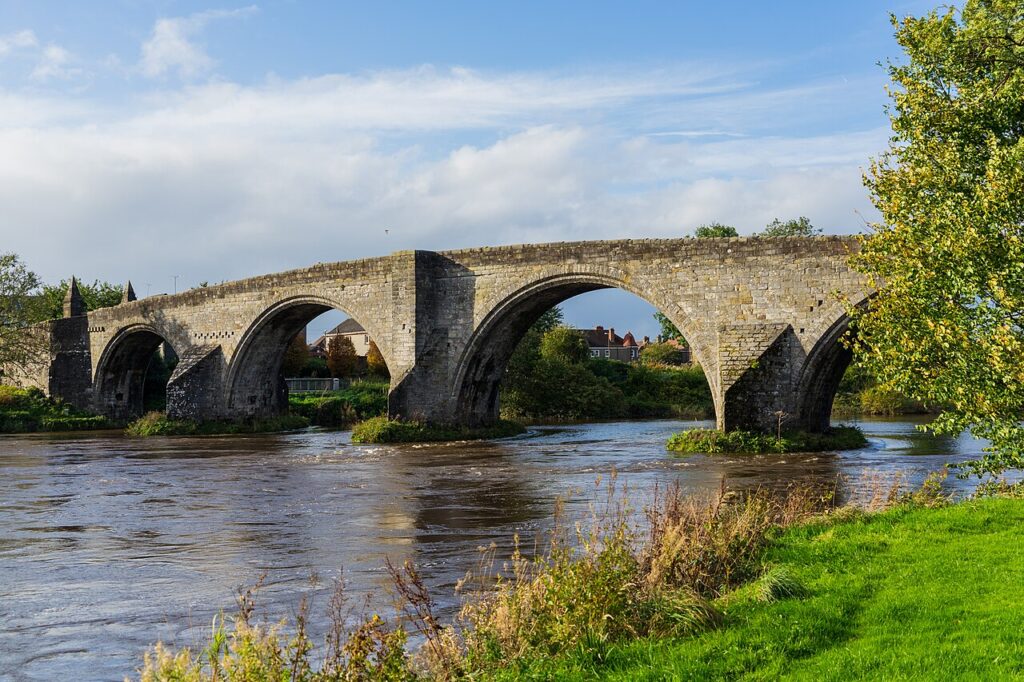
Stirling Bridge (Image credit: Iain Cameron, CC BY 2.0 <https://creativecommons.org/licenses/by/2.0>, via Wikimedia Commons)
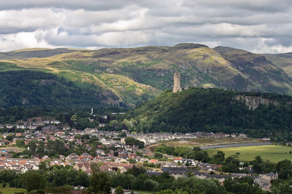
Abbey Craig
Abbey Craig is a several-hundred-million-year-old volcanic fist, punched upwards from the bottom of a rift valley. Like Stirling Castle, it controls the Forth crossing points. The wee hillfort here is also vitrified, but dates to around AD 900 (1,100 years ago), making it perhaps one of the last hillforts ever built in Scotland.
Dr Cook and his team have been digging at the fort since 2010 and they were able to use the charcoal they recovered to date the fort using radiocarbon dating. According to Dr Cook, it’s most likely a Pictish defence which was built to secure their frontier and may have been destroyed by raiding Vikings.
While you’re visiting, be sure to stop at the National Wallace Monument, which is one of the biggest monuments to an individual in Britain (and also importantly, has a café and toilets).
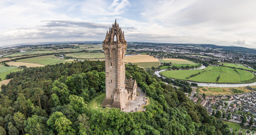
The Wallace Monument Aerial, Stirling (Image credit: BusterBrownBB, CC BY-SA 3.0 <https://creativecommons.org/licenses/by-sa/3.0>, via Wikimedia Commons)
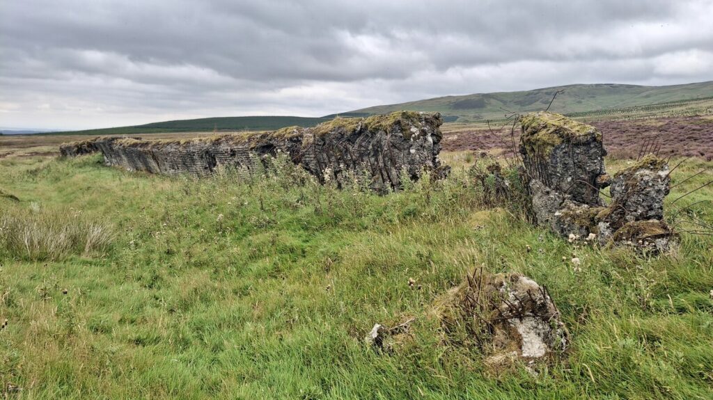
Sheriffmuir’s Replica Atlantic Wall
This might be one of the most important archaeological sites in Scotland: a top-secret research base used by the British government during World War II to figure out how D-Day was going to work.
D-Day took place on 6 June 1944 and was the single largest amphibious invasion in history, involving over 5,000 ships and 175,000 troops from 15 different nations. It was incredibly important, as Professor Tony Pollard FSAScot, Director of the Centre for Battlefield Archaeology and a Professor of Conflict History and Archaeology at the University of Glasgow, has said: the end of the Nazis started here!
Following the Nazi’s occupation of Europe, Hitler ordered the construction of a massive series of defences along Europe’s coastline. A key element of these was the infamous Atlantic Wall which was constructed from reinforced concrete and designed to repel tanks.
To determine how to breach these walls, the British formed the Anti-Concrete Committee in 1943 and the plans for the Atlantic Wall were smuggled out of occupied Europe in a biscuit tin. The British then constructed a series of replicas in England and Scotland to test methods of breaching. Some of the biggest and best preserved of these can be found at Sheriffmuir in Stirling.
The complex of reconstructions reflects both German offensive and defensive positions and recreates the ground conditions and distances from the landing craft in the sea all the way to the wall. The Atlantic Wall replica at Sheriffmuir is a massive block of reinforced concrete that was 86m long, about 3m in height and up to 3m thick. As it was used for target practice, it’s covered with hundreds of missile impacts. If you close your eyes, you can almost hear the explosions, feel the shocks and smell the gunpowder!
The site was recorded via archaeological survey in 1998 and designated as a nationally important monument five years later.
The Atlantic Wall, Sheriffmuir (Image credit: Gordon Brown, CC BY-SA 2.0 <https://creativecommons.org/licenses/by-sa/2.0>, via Wikimedia Commons)
Want to help uncover stories like these in Stirling? Sign up to Dr Cook’s Substack to join him on a dig.
By Dr Murray Cook FSAScot, Stirling Council’s Archaeologist giving archaeological advice to Stirling, Clackmannanshire and North Lanarkshire Councils.
Header Image: The Wallace Monument in Stirling (Image credit: Eusebius, CC BY 3.0 <https://creativecommons.org/licenses/by/3.0>, via Wikimedia Commons)
