Five of the Best Archaeology Projects at the National Trust for Scotland
2021 marks the 90th anniversary of the National Trust for Scotland and close to 30 years of having an in-house archaeology team. As Scotland’s largest combined natural and cultural heritage charity, the Trust has over 76,000 hectares of ground including around 12,000 archaeological features, of which about 100 are scheduled monuments (meaning they are nationally important and legally protected).So there has always been plenty of opportunities to undertake exciting archaeological projects which help us understand the places we care for better and allow the public to get involved.
As the Trust is currently preparing a 10-year strategy that will take the organisation towards its centenary in 2031, it seemed appropriate to look back on some of the previous successes:
Upland Landscapes at Beinn Labhair (Ben Lawers)
Landscape archaeology is the study of how people in the past have altered and used their surrounding environment. It is a multi-disciplinary approach focusing on the relationships between people, material culture (objects) and the natural environment.
The Trust has in its care large areas of unimproved upland environment (high above sea level) and extensive areas of rough-grazing. As Scotland’s third largest land-owner, the Trust plays a key role in the management and advocacy for conservation of the Scottish countryside. One of its key responsibilities therefore is to understand how the landscapes that we see today have evolved over time and what significant stories need to be told.
The Ben Lawers Historic Landscape Project was set up to investigate the rich array of post-medieval settlement remains (dating back a couple hundred years) on the northern side of Loch Tay in the Highlands but in fact did much more than this, highlighting use of the landscape stretching back thousands of years into prehistory.
A wide range of specialist researchers contributed to the project including historians, archaeologists, geophysicists, palaeo-environmental scientists and soil scientists, amongst others. The results of this work (including the discovery of stone discs used for pressing cheese) was published as a Scottish Archaeological Internet Report (SAIR).

Digging the shielings (huts) at Meall Greigh (part of the Beinn Labhair range) (© National Trust for Scotland)
Battlefield Archaeology at Chùil Lodair (Culloden)
From its outset, the Trust has been involved in the conservation of Scottish battlefields. The charity has been at the forefront in managing and interpreting two of Scotland’s best-known sites, Bannockburn in Stirling and Chùil Lodair near Inbhir Nis (Inverness), which attract thousands of visitors and school children each year. Archaeology has played a huge part in the understanding of the battlefield at Chùil Lodair along with detailed documentary and cartographic (map) research.
Both Tony Pollard, Director of the Centre for Battlefield Archaeology and a Professor of Conflict History and Archaeology, and his colleagues at the Centre for Battlefield Archaeology at the University of Glasgow were key to including the results of recent research into the interpretation at the site. Archaeological artefacts and research now features prominently in the displays within the Visitor Centre.
Systematic use of metal detecting has not only allowed the battle lines to be re-drawn, but has also provided a wealth of artefacts and personal effects that often bring the visitor strikingly close to the brutality of 18th century. In addition to buttons and buckles, the most common find was a wide range of ammunition (including pistol and musket shot) and artillery rounds (including canister, grape and round shot). Many of the musket balls were flattened from impact.
Most recently, LiDAR survey (a form of laser scanning) of the battlefield has been used to help map the micro-topography and to overlay historic maps and metal detecting finds locations.
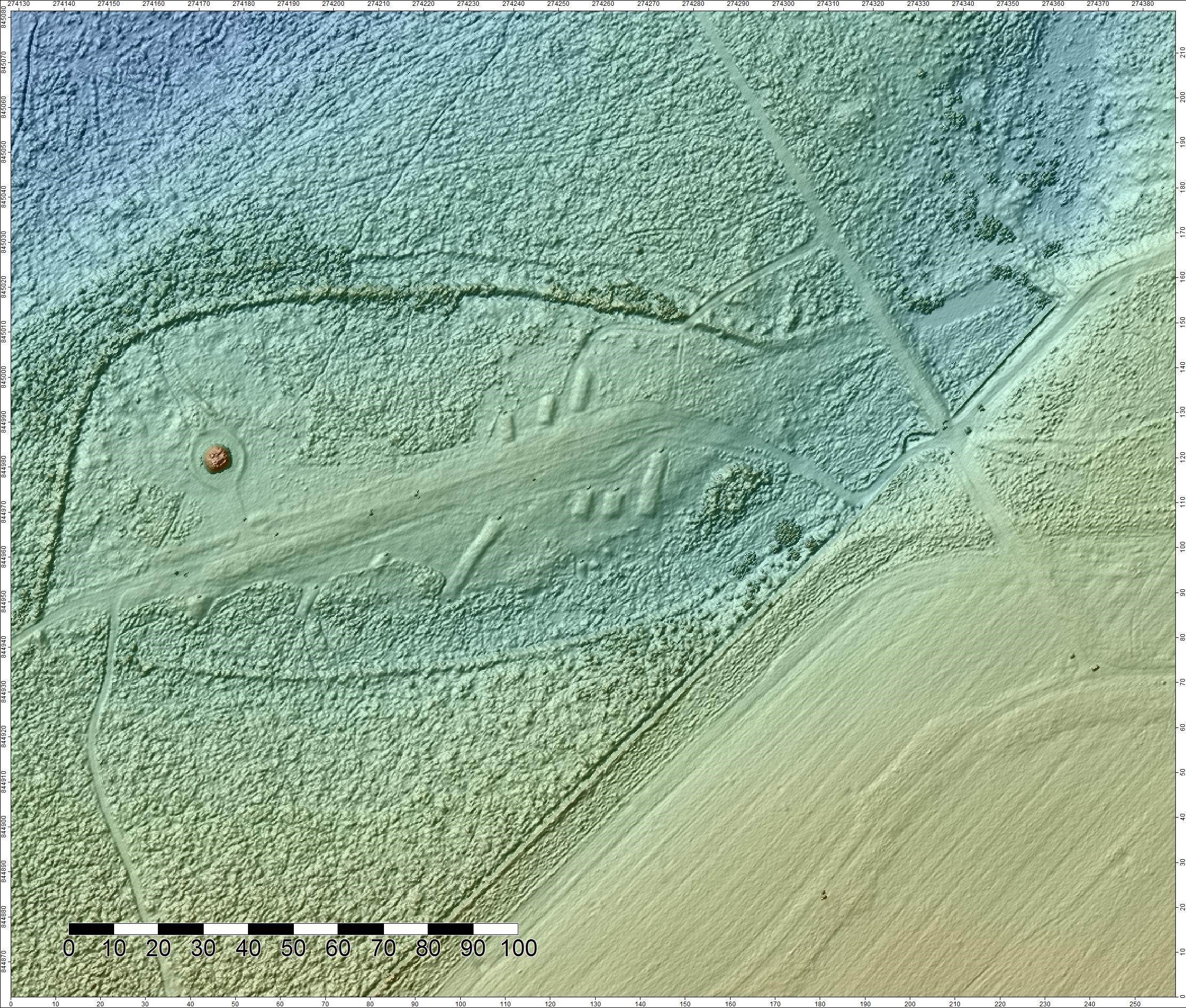
Chùil Lodair LiDAR survey of clan graves (© National Trust for Scotland)
Island Archaeology on Hiort (St Kilda)
The Trust has around 400 islands or parts of islands in its care (and numerous stretches of coastline) and each has its own archaeological story to tell. These include the Hiort archipelago, Miughalaigh (Mingulay), Pabaigh (Pabbay) and Beàrnaraigh na Hearadh (Berneray) in Na h-Eileanan Siar (the Outer Hebrides), Canaigh (Canna), Stafa (Staffa) and Ì Chaluim Chille (Iona) in Na h-Eileanan a-staigh (the Inner Hebrides), Fair Isle in Shetland, and properties on Eilean Arainn (Arran) and An t-Eilean Muileach (Mull) off the west coast of Scotland and Unst and Yell in Shetland.
Of these islands, isles, islets and stacs, only 10 are permanently inhabited – Hiort and Miughalaigh’s final islanders famously departed in 1930 and 1912 respectively. The surviving archaeology – such as roofless cottages and the black houses on the main street with their empty windows and open doorways – plays a significant role in reinforcing the feeling of desolation.
Over the last 30 years, detailed archaeological surveys and excavation campaigns on Hiort have been undertaken and published. While excavation has found evidence of human activity from the Bronze Age (over 2,800 years ago) onwards, the most detailed remains date to the 19th and early 20th century. The structural remains are dominated by the dry-stone cleits (huts) which were used to store and dry produce such a seabirds, eggs, feathers, peat and wool. It is perhaps one of one most detailed studied landscapes, as is fitting of its status as a dual World Heritage Site (meaning that is has both natural and cultural significance).
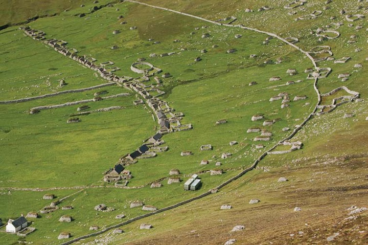
Cleits (huts) and houses in Hiort’s Village Bay (© National Trust for Scotland)
Gardens and Designed Landscapes at Newhailes
When most people think of the Trust, they probably picture castles and large houses which are certainly a large part of the charity. The surrounding gardens and designed landscapes have almost all been the subject of detailed survey work, especially as these areas are often those most under pressure for change. We have commissioned a wide range of geophysical surveys, followed by trial trenching, in the immediate vicinity of castles and major houses has located demolished 17th-and 18th-century walled gardens at Fyvie Castle in Aberdeenshire, geophysical plots of parterres (forming an ornamental garden) at Crathes Castles in Aberdeenshire and excavated remains of complex heating systems of the vinery at Culzean Castle in Ayrshire.
One of the gardens where the Trust has done most extensive investigations is into the 18th century gardens at Newhailes in East Lothian, where excavations and survey have uncovered remains of the once-dramatic landscape features such as the cascades in front of the shell grotto, the collapsed tea-house, and the beds of the flower garden.
The archaeology of historic gardens is something the Trust leads the way in, both in terms of understanding historical development and planning and in the combined results from numerous small scale surveys and interventions across our properties. We have good examples of investigations into glass houses, flower gardens and walled-gardens. This has resulted in a much more detailed understanding of the wide range of features that made up these designed landscapes and has contributed to their ongoing conservation and interpretation.
In addition, we have undertaken recording work on features/structures in the wider estates such as ice-houses, ponds, mills, lime-kilns, doo-cots, and kennels.

Digging in front of the shell grotto at Newhailes (© National Trust for Scotland)
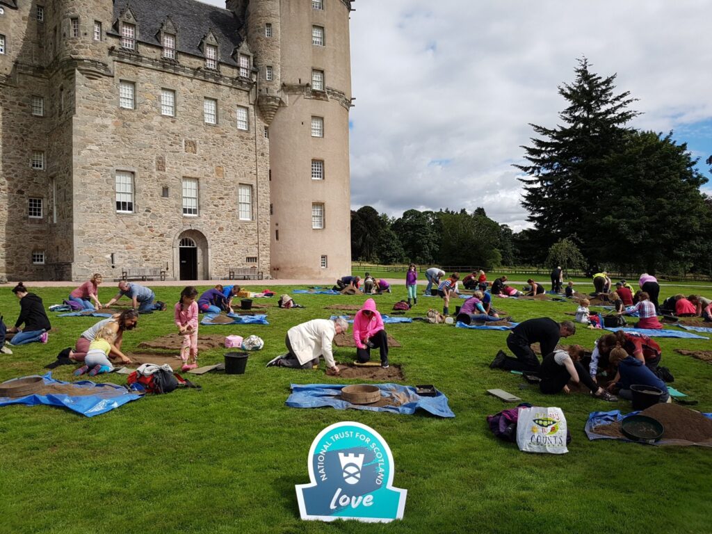
Public Archaeology at Castle Fraser
Archaeology is both the material remains of that past (anything that was left behind or lost that represents human activity) and the process of its recovery. We want people to engage with these deeper stories by explaining the past through the physical remains of our places, landscapes and objects. We also want them to benefit from being able to participate in the recovery and understanding of evidence by taking part in archaeological surveys and excavations.
In recent years, one of the most successful programmes of public engagement has been public test pitting. A test pit is a small square trench, usually 1m by 1m. It is a mini excavation in its own right. While one might be too small to discover a lot, you can investigate a lot of ground if you dig 50 over a grid pattern 5m apart.
When we invite volunteers, members of the public and visitors to our properties to come along and dig one, everyone has the chance to discover real artefacts in the topsoil and expose features such as walls and floors.
This is a technique and event that has worked very well at many of our castles and historic houses such as Crathes, Culzean, and Castle Fraser in Aberdeenshire (where we welcomed 200 people in one weekend), but also at Bannockburn and the Weaver’s Cottage in Renfrewshire.
At Castle Fraser, this resulted in the discovery of series of outer walls that surrounded the castle on the south side. Test pitting has also revealed a wide range of artefacts including historic pottery, glass and metalwork. One notable find, made by a 10-year-old boy, was half of a silver coin of Elizabeth I of England, dating to the 1570s.
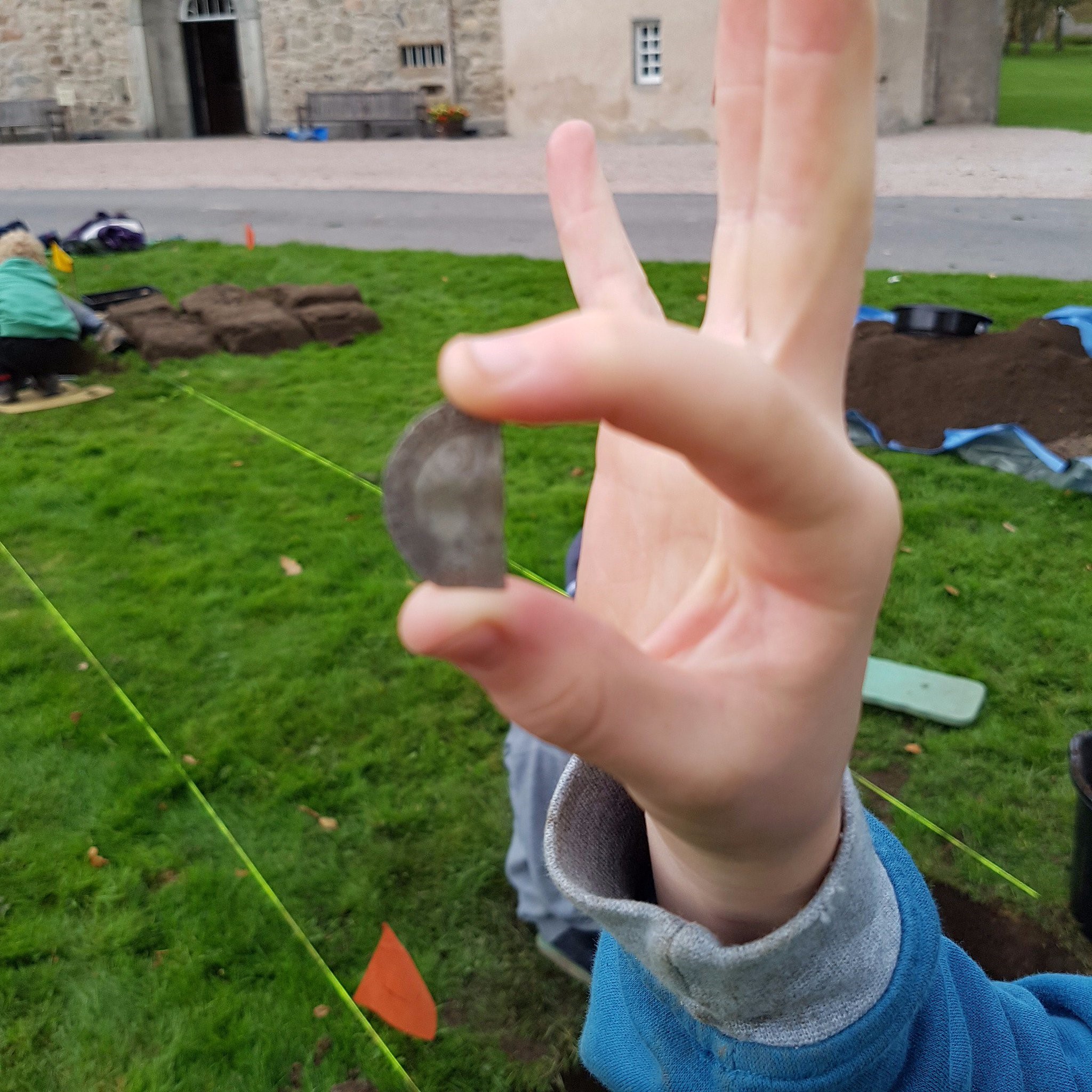
16th-century silver coin find at Castle Fraser (© National Trust for Scotland)
Want to know more? Visit the Trust’s website to keep reading about their archaeological work.
By Derek Alexander, Head of Archaeology at the National Trust for Scotland
Header Image: Test pitting at Castle Fraser (© National Trust for Scotland)
