Cream of the Crop: What Are Cropmarks and Why Are They Important?

What do you think of when you hear the word “cropmark”? And what have cropmarks got to do with archaeology?
Cropmarks have a key part to play in archaeology, as they’re one of the ways that we can find out about what’s buried beneath our feet, without even putting a spade in the ground.
What are cropmarks?
Cropmarks are the phenomenon where buried features affect the growth and ripening of crops growing above them. This creates colour and height differences in the crops, which we can record from the air and interpret to understand what survives beneath the soil. They can be created by geological features or human-made features and it’s up to archaeologists to examine patterns in the crops and decide what could be a sign of past human activity.
It’s worth noting that cropmarks are not the same as crop circles – no pranksters are involved in the creation of cropmarks!
What do cropmarks tell us about Scotland’s past?
Cropmarks help us to ‘see’ remains that would otherwise be invisible. While historic banks or walls may have been ploughed flat over time and ditches and pits infilled, the buried or below-ground elements of these features can survive. That includes, for example, postholes that have become filled with soil, infilled ditches or the base of banks or walls.
These buried remains can either retain more nutrients, soil depth and moisture or they can inhibit root growth and reduce moisture and nutrients. Certain crops growing above these features will therefore grow in a different way, with cereal crops such as barley being the most sensitive to differences in the soil. Crops growing over features such as pits or ditches can produce deeper roots and, in certain circumstances, will grow better, taller and will ripen more slowly. The opposite can happen to crops growing above compact features, such as wall foundations, because they have less access to soil depth, moisture and nutrients.

© Kirsty Millican
Weather patterns also play a big part in cropmark formation; in particular how dry it is during the growing season. In very dry years, grass can reveal features as parchmarks, where shallower soil dries out more quickly in the sun and the grass turns yellow (because it’s parched). So do look at the grass in your local park for potential signs of buried remains if we have a very dry summer!
Are cropmarks important?
There are just over 9,000 cropmark records in the National Record of the Historic Environment (NRHE) and this will grow as more are recorded every summer! If a new cropmark site is identified by Historic Environment Scotland (HES) or brought to our attention, it’ll be added to the NRHE. Some may be considered for protection, but only a few cropmark sites will ever be excavated.
Some of these cropmark sites are so important that we give them legal protection. HES maintains a Schedule (a list) of monuments of national importance, both above and below the ground or the sea. Scheduling began back in 1882 and is the process of adding monuments to this list under the Ancient Monuments and Archaeological Areas Act 1979. The aim is to preserve our most significant sites and monuments as far as possible in the form in which they have been passed down to us today. You can find information on all our scheduled monuments via the HES Designations Portal.
Although we have been scheduling for almost 150 years, it wasn’t until the 1960s that we began to add cropmark sites. One of the earliest cropmark sites to be scheduled was at West Gallaberry in Dumfries and Galloway. This monument is a temporary Roman camp alongside a prehistoric settlement which were both identified by archaeologist O. G. S. Crawford through aerial survey in 1939.
Archaeological excavations in the same year supported Crawford’s interpretation that this was a Roman camp built in the first few centuries of the first millennium AD (around 2,000 years ago now), and it was scheduled as a monument of national importance in 1960. In light of new understandings of the Neolithic, later re-analysis of the site has also identified the parallel lines of the ditches of a possible cursus monument.
Roman temporary camp at Gallaberry, Dumfries and Galloway SC1758805 (© Crown Copyright: HES)
An important part of our work is to maintain the records that underpin the monuments on the Schedule. One of the ways we’re doing this is by reviewing the scheduled cropmark sites and updating them where necessary – eventually this will mean looking at over 1,000 records!
Are Cropmark Sites Disappearing?
There are a lot of misunderstandings around the remains recorded through cropmarks.
You might have heard that all cropmark sites are being ploughed away. Most sites known from cropmarks are indeed in cultivated land, which means they have either been ploughed in the past or are being ploughed today. However, others are only in cultivation for very short periods and others have been taken out of cultivation altogether since they were recorded. So it’s not inevitable that all cropmark sites will be ploughed away.
Equally, if a particular site hasn’t been recorded for some time, this doesn’t necessarily mean that it’s been destroyed and no longer exists. Some sites have only been recorded in cropmarks once, others are recorded only intermittently. But factors like having the “right” kind of crop planted within it affects whether we see cropmarks. A site may not have been recorded for years simply because a survey aircraft hasn’t flown over it for some time or at the right time of year!
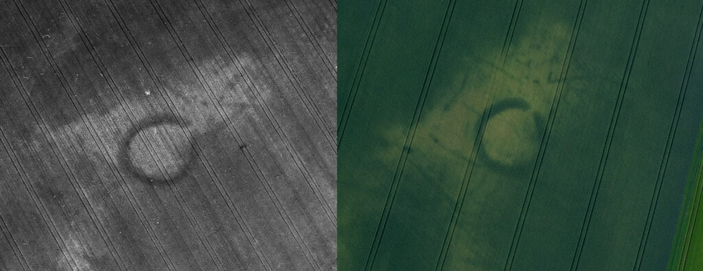
Balmacolm Farm, Henge (Scheduled monument SM6835; Canmore ID 31291), recorded in 1993 (left) and 2023 (right) SC1714638 (© Crown Copyright: HES, DP407321 © Historic Environment Scotland)
Sites recorded as cropmarks over several years may look slightly different in different years. In some years the cropmarks may be very clear and sharp, in others the cropmarks will be fuzzy and less defined. You might think that the differences in how the cropmarks themselves look like might tell us something about the condition and survival of the archaeological features that create them, but because so many different factors affect how cropmarks form, what cropmarks look like tells us very little about condition and survival
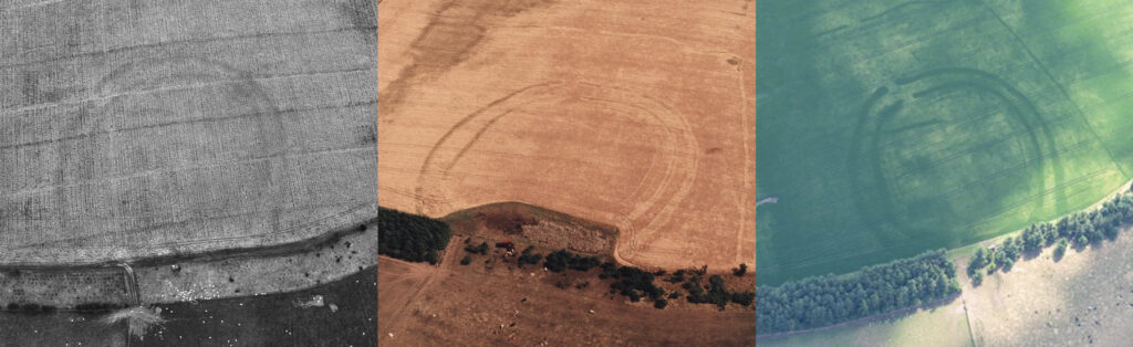
Birkenside Hill, Fort, (Canmore ID 55938) recorded in 1983, 1995 and 2018 SC1743003, SC1743034 © (Crown Copyright: HES; DP280766 © Historic Environment Scotland).
Top Cropmark Sites to Know
Forteviot Power Centre in Perth & Kinross
In the 1970s, archaeologists recorded the cropmarks of this huge prehistoric complex with a massive timber enclosure and multiple henges, as well as a Pictish cemetery, after it was identified because of cropmarks.
Excavations between 2007 and 2011 as part of the Strathearn Environs and Royal Forteviot (SERF) project revealed a lot about this complex, which appears to have been a major centre of power both in the Late Neolithic/ Early Bronze Age period (c. 3100 – 1900BC) and then again in the early medieval period (c. AD 400 – 900). The project radiocarbon dated some of the environmental evidence they had gathered (such as charcoal and seeds) which showed that the site was first used in the Neolithic (over 5,000 years ago), and then occupied and reused through into the early medieval period (over 1,000 years ago). One particularly fine discovery was the most complete Bronze Age fire-making kit currently known from anywhere in Europe, which was being used around 4,000 years ago.
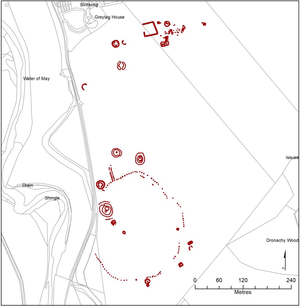
Map of the cropmarks at Forteviot (Cropmark mapping © Historic Environment Scotland. Contains Historic Environment Scotland and Ordnance Survey Data © Historic Environment Scotland © Crown copyright and database rights 2024 Ordnance Survey [AC0000807262]. Ordnance Survey Data)
Eckford Mill in the Scottish Borders
Eckford Mill is a complex funerary site, consisting of a round barrow (burial mound), pit circle and enclosure, that probably dates to early Bronze Age (over 4,000 years ago) Unlike Forteviot, it’s never been excavated but we can still tell a lot about it from the cropmarks.
The ditch of the round barrow is visible as a thick dark ring, but a mound of earth that would’ve originally covered the area enclosed by this ditch has been removed by ploughing. Within this central area is a series of small circular dark marks (pits) which may have originally held timber posts that probably formed a timber circle. All of these features lie within a larger circular enclosure, the ditch of which is visible as the narrower dark ring.
It’s been interpreted that these elements would’ve been built one after the other. The timber circle may have been a structure or enclosure associated with funerary rituals, and one or more burials may have been placed somewhere within the timber circle. The barrow was created by digging the wide ditch and using the earth dug out of the ditch to make a mound that covered both the burial and possibly the timber circle, or at least the pits used to hold the posts.
Finally, it’s thought, the outer enclosure was created. We don’t know whether this happened at the same time the barrow was built or later. We also don’t know if it was simply an enclosure, possibly accompanied by a small bank, or if it was an expansion of the barrow mound with more earth piled up in the area it encloses.
As you can see, we can get so much information about this site simply from an aerial photograph, including a unique insight into the interior structure of a round barrow without breaking the ground.
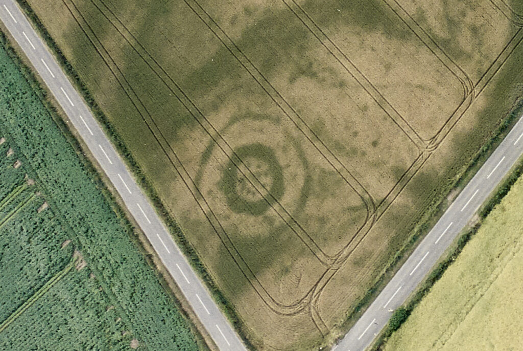
Aerial photograph showing Eckford Mill round barrow, pit circle and enclosure (Scheduled monument SM13764, Canmore ID 166387) SC1749217 (© Crown Copyright: HES)
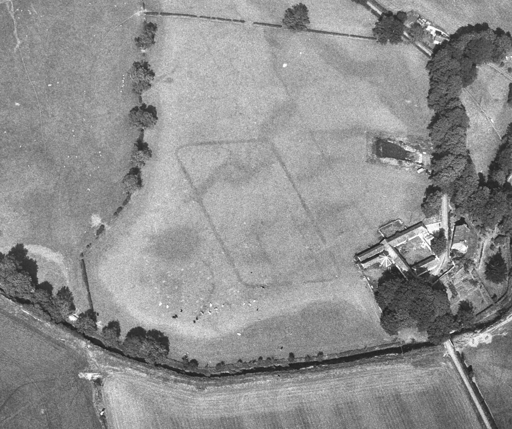
Knowes Settlement in East Lothian
Initially identified as a roughly square enclosure with a series of circular “blobs”, excavations at Knowes as part of the Traprain Law Environs Project in 2004 confirmed that this was an Iron Age settlement founded in the first or second century BC (some 2,000 to 2,200 years ago) with a central house or dwelling that had a long and complex history.
The site was abandoned by the end of the second century AD and a stone lined burial (known as a cist) – which was not visible as a cropmark – was inserted into the southern end of one of the enclosing ditches and considered by the excavator to mark the ceremonial closing of the site.
The cist contained human remains which were much older than the settlement, which suggests that the remains had been either curated over many years and only laid to rest after the life of the settlement, or had been dug up from elsewhere and buried on the site. Both possibilities strongly suggest that this was some kind of symbolic gesture.

Aerial photograph showing Knowes Iron Age settlement (Scheduled monument SM4070, Canmore ID 57720) SC1747541 (© Crown Copyright: HES)
Holywood South Monument in Dumfries and Galloway
First recorded in the 1970s, Holywood South is the site of a cursus monument which was built between around 3600BC and 3000BC (over 5,000 years ago). Cursus monuments are long, linear enclosures defined by a bank and ditch, and we think they were ritual or ceremonial monuments.
At Holywood South, the bank that would’ve defined the monument no longer survives, but the infilled ditches are visible as darker lines in the crop with gaps suggesting entrance causeways. Cursus monuments were impressive and they enclosed space on a scale never seen before. At 280m in length, this is actually one of the shorter ones in Scotland!
The cropmarks give a wonderfully clear overview of this site. That they are so clear is a testament to the impact that this monument must’ve had when it was first built. What did Scotland’s Neolithic residents think when they first saw it? How did they interact with it and how was it used? We don’t have all the answers and sites like this raise many questions. But it’s the cropmarks that allow us to find and identify sites like Holywood South and to ask – and try to answer – those questions.
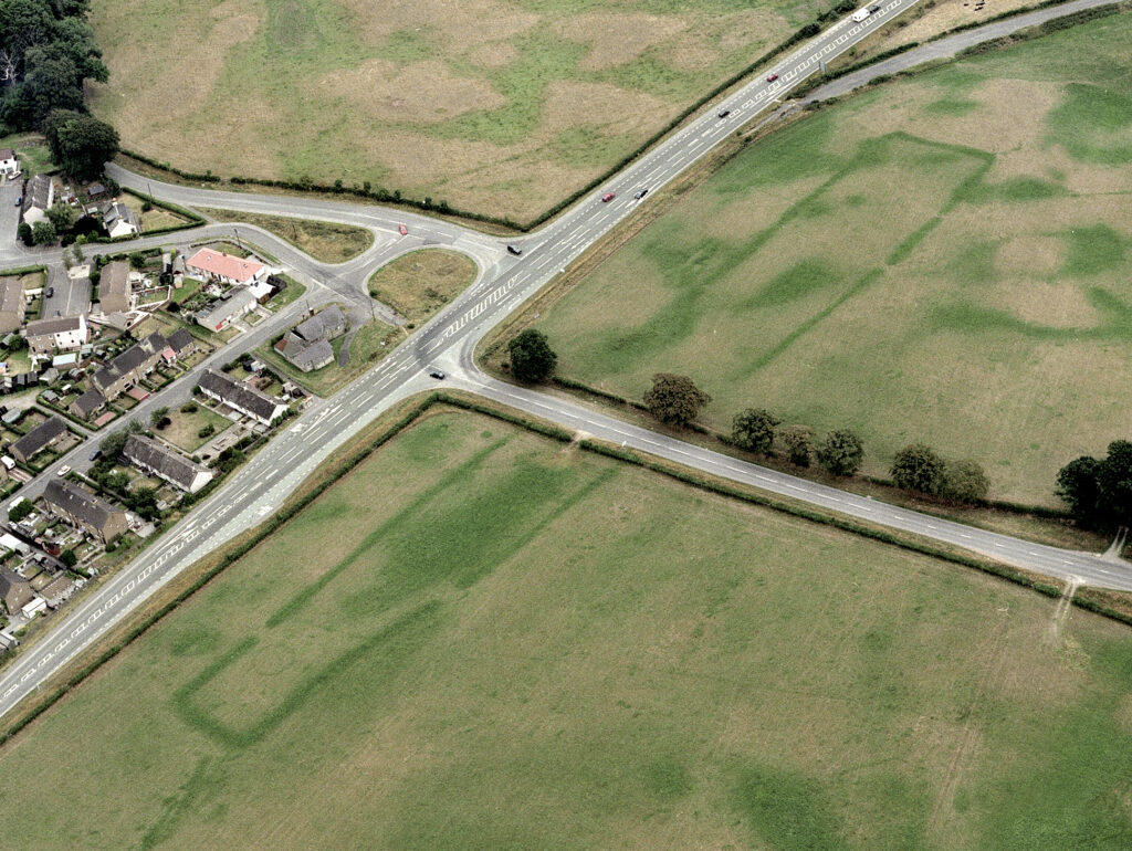
Holywood South Cursus (Scheduled monument SM4217, Canmore ID 65652, SC622986) (© Crown Copyright: HES)
Gallamuir Fort in Stirling
The double ditches of this prehistoric fort have been recorded in cropmarks as two huge oval rings, the size of which tell us that this was a substantial site, intended to impress. Although it hasn’t been excavated, comparisons with others have suggested it’s likely to be later prehistoric in date (over 2,000 years ago).
It will have once enclosed a cluster of roundhouses although only one or two likely “blobs” are all that can be seen on this image. The occupants would’ve farmed the surrounding area much like the modern farmers nearby. This tells us that the area has been farmed, and probably continually occupied, for thousands of years. It’s not every farm that can trace its origin to a prehistoric fort!
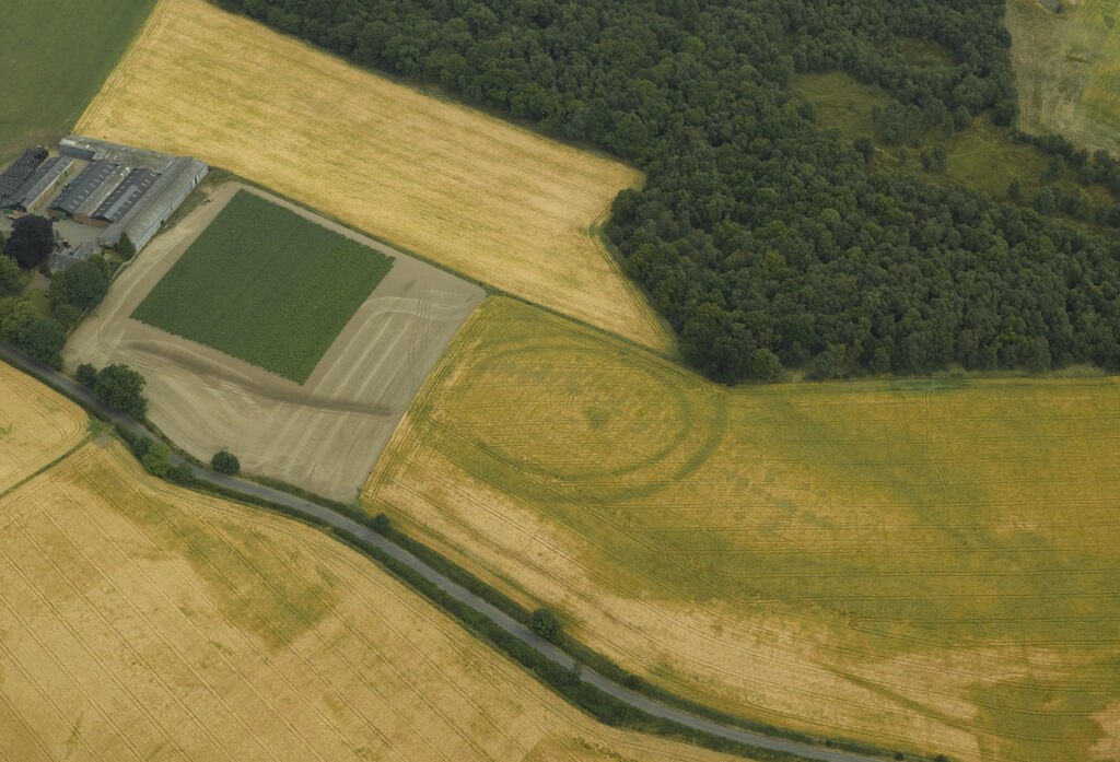
Crop-marks on APs (CPE/Scot/UK 251: 5083-4) reveal the double ditches of an oval earthwork 250 yds ESE of Gallamuir farmhouse (Scheduled monument SM3948, Canmore ID 46889. DP010855) (© Crown Copyright: HES)
Glamis Castle in Angus
Glamis Castle is probably best known for its associations with the British Royal family. However, there’s been a castle or stronghold at the site since the 10th or 11th century AD (over 900 years ago). The formal gardens around the castle have undergone many changes over the centuries and this aerial photo gives us an interesting glimpse into the past.
The parchmarks – which can be seen as sharply straight and thick lighter marks that project from below the current buildings with a road running through them – show the foundations of the walls of the 17th-century inner court of the castle. To the east (on the right of the photograph) are the paths of the formal garden of the same date. To the west (on the left of the photograph) are the very faint remains of a bowling green.
All of these features were removed in AD 1773 as part of plans to create a new landscape garden. What does survive are the buried remains that have created these parchmarks and the sundial standing at the centre of the former garden (visible where the old paths meet).
This photograph shows that parchmarks and cropmarks can provide glimpses of the remains of the past from all eras. It’s especially interesting because we know the date when these features were removed. That is very unusual in archaeology!
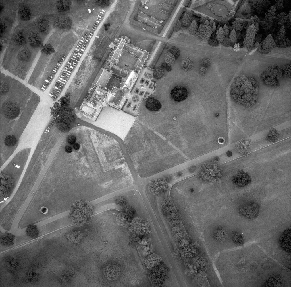
Glamis Castle Gardens SC937768 (Crown Copyright: HES)
Wondering if there’s any cropmarks near you? It’s sometimes possible to see them from a slight rise or an elevated position, so it’s worth searching for cropmark images on Trove and exploring our Designations Portal before heading for the hills.
All the aerial images in this article (and thousands more) can also be found on the publicly accessible NRHE.
And of course, there are still lots of cropmark sites that aren’t scheduled. If you know of one, you can ask to assess it and have it added to the Schedule.
By Dr Kirsty Millican FSAScot, Senior Designations Officer at Historic Environment Scotland. Kirsty is an archaeologist and heritage professional with experience in aerial and cropmark archaeology, geophysical survey and archaeological interpretation. Her research interests include Neolithic and Early Bronze Age Scotland, cropmark archaeology, archaeological interpretation, and the relationship between humans and the environment in prehistory.
By Rory McDonald FSAScot, Deputy Head of Designations (Inventories and Marine) at Historic Environment Scotland. Rory is a heritage professional with 30 years’ experience in heritage protection, database management, and heritage interpretation. His research interests include Scottish medieval archaeology, aerial archaeology, and how nature and archaeology interface.
Want to keep reading? Dig in to more guides on archaeological techniques in our Decoding Archaeology series.
Header Image: The Chester, Spott, East Lothian (Scheduled monument SM5766, Canmore ID 57792; DP163230) (© Crown Copyright: HES)
