Top Six Archaeological Sites and Discoveries in Badenoch in the Cairngorms
As the UK’s largest national park, the Cairngorms boasts hundreds of historic sites spanning thousands of years of human history. Across its 4,500 square kilometres, you can encounter many castles and forts with fascinating stories to tell, but it’s not all about what lies above the surface.
Dig into six of our top archaeological gems from the Badenoch region of the Cairngorms, in the heart of the Scottish Highlands.
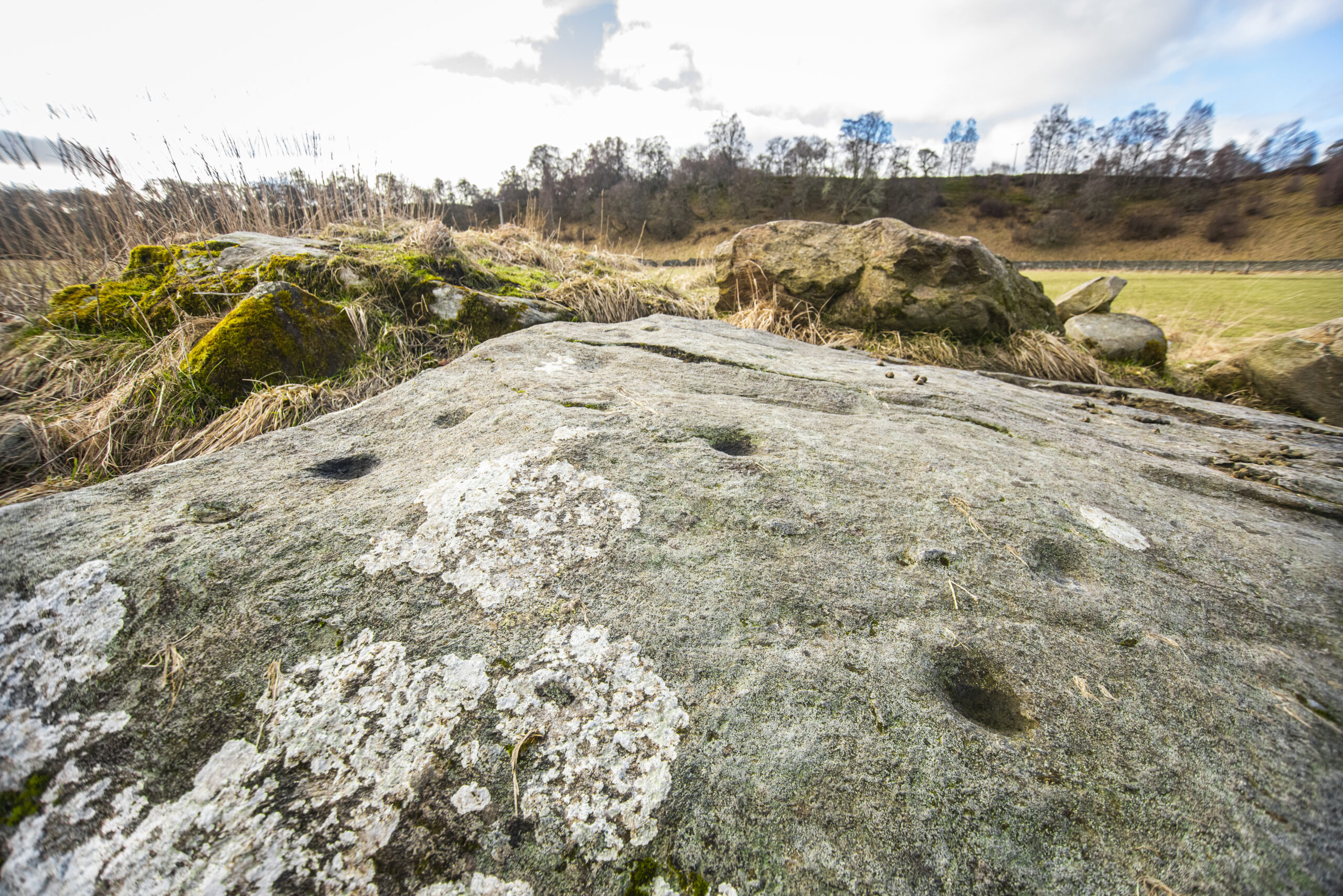
Prehistoric Rock Art
Across Scotland, you can find thousands of natural outcrops and boulders carved during the Neolithic (c.6,000 to 4000 years ago) and Early Bronze Age (4,000 to 2,000 years ago), but little is known about who created them and why.
We know from studies of societies in other parts of the world that rock art was produced by people with special ritual status. It’s possible that Scotland’s rock art was created by ‘ritual specialists’, or people with a particular role in the community.
(© James Stevens via VisitCairngorms)
Some areas of the country are renowned for their density of elaborate rock art (such as Kilmartin Glen in Argyll), but there are also parts of Scotland, such as the central Highlands, which appear to have none at all, and experts aren’t sure why.
This makes the rock art found in the Cairngorms, such as the examples at Laggan hill, the Highland Folk Museum and Milton of Balnapoul Sluggan, relatively rare. They feature the most common symbols – a small circular hollow pecked into the rock known as a ‘cupmark’ and a cupmark surrounded by one or more concentric circles known as a ‘cup-and-ring motif’ – which were likely created by hammering surfaces with stone tools or large river pebbles.
Visitors can seek out these carvings as well as look for new ones (and report them), as many rock art sites are discovered every year and it’s likely that more are still waiting to be found.
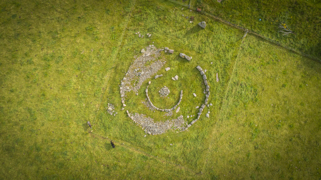
Delfour Ring Cairn
This prehistoric monument near Alvie is made up of a ring-cairn (a circular bank of earth or stones surrounding a hollow central area) which was once surrounded by a great stone circle.
Delfour is classed by archaeologists as a ‘Clava cairn’ and is thought to date to the Early Bronze Age, around 3,500 to 4,500 years ago.
An 1845 account describes this monument as ‘the remains of a Druidical Cairn’ and goes on to wonder whether the cairn might mark the grave of an important person. The author also notes that the site still appears to be venerated locally, as the stones have been allowed to remain standing in prime farming land.

Delfour ring cairn (© James Stevens via VisitCairngorms)
The purpose of ring cairns is still debated, but it’s possible that they were funerary sites, as the stain of a crouched body was found at Corrimony and traces of cremated remains have been identified at Balnuaran of Clava.
Whether or not people were buried at Delfour, the site does appear to have been of special ritual significance, with experts noting that the builders carefully orientated the monument to point towards where the sun would set at midwinter.
Sadly, many of the stones that made up the monument have been robbed in recent times, with only two stones remaining of the circle that once surrounded the cairn. But visitors can still visit the site and wonder what ceremonies occurred here thousands of years ago.
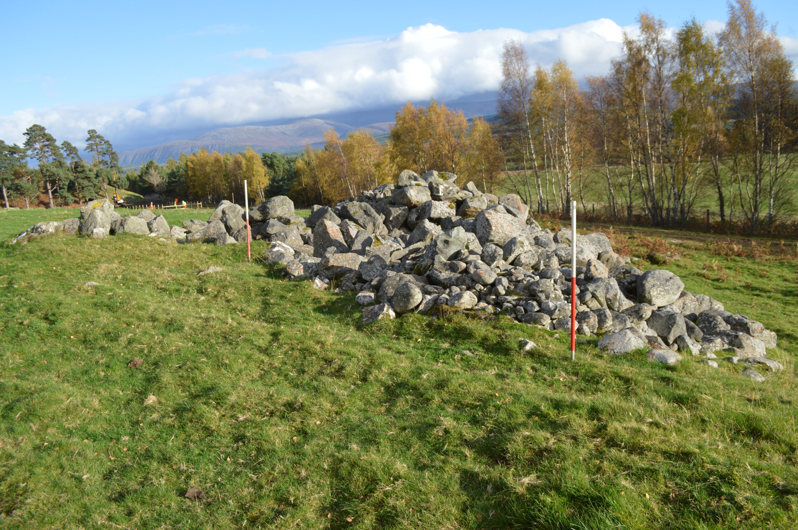
Croftgowan Barrow Cemetery and Torr Alvie Hillfort
In the shadow of Torr Alvie lies the largest Pictish barrow cemetery ever discovered in Scotland.
The Croftgowan cemetery is home to dozens of barrows (burial mounds) and is at least 1,100 years old. Around AD 1800, human remains, pieces of sword blades, and buckles were discovered when several mounds were investigated prior to cultivation of the field.
The site exists today mainly as a cropmark best seen from above. Aerial photographs were taken in 1977 capturing a number of circular and square barrows, but in 2018 hot dry weather resulted in many more very clear crop marks appearing, including a new group of round barrows.
In 2021, volunteers worked with experts from the University of Aberdeen’s Northern Picts project to excavate the site as part of the Badenoch Great Place Project. They uncovered preserved human remains – including enamel caps from the individuals’ teeth – in one round barrow and in another the “remarkable” body stain of a person interred in the grave. The skeletal remains of this person had dissolved but left evidence of the body posture and layout of the individual with the shadow of features such as the kneecaps still visible.

Drone image of trench 5 at Croftgowan barrow cemetery – two conjoined square barrows and a round barrow (© Northern Picts Project)
The same team also excavated the remains of an ancient hillfort located at the summit of the hill above Croftgowan cemetery, which once held commanding views from Loch Alvie to the River Spey.
The oval-shaped structure was unrecorded until 2011 when members of the community archaeology group North of Scotland Archaeological Society (NOSAS) identified the site and produced a measured sketch plan of the 60m long and 27m wide fort.
The 2021 team excavated sections across the wall of the fort and retrieved samples of charcoal, which will be radiocarbon dated to determine the age of the settlement features and of the bank itself.
Both the cemetery and the hillfort are hugely important to our understanding of Pictish life and death in Scotland, and it’s likely that future excavations will reveal much more.
You can find out more about the results of the excavations at this upcoming event as part of the Badenoch Heritage Festival on 18 September 2022.
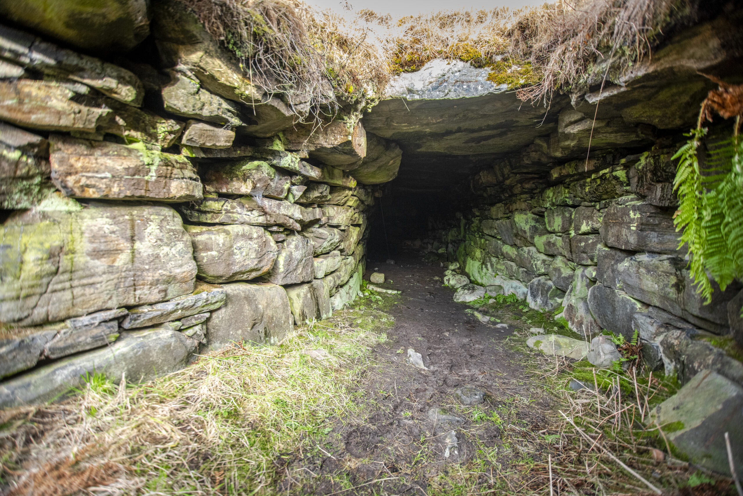
Raitts Souterrain
Raitts souterrain (also known as Lynchat, Uamh Mor or Raitts Cave) is a well-preserved prehistoric underground passage near Kingussie.
The U-shaped passage is large compared with most similar examples in the north of Scotland (around 25m long, 1.3m wide and up to 2.2m high).
Raitts Souterrain (© James Stevens via VisitCairngorms)
Why souterrains were constructed and what they were used for is still debated by archaeologists. According to legend, Raitts was built by giants and giantesses, who carried the excavated soil to the River Spey in their aprons. They are commonly associated with settlement in the Bronze Age and Iron Age, over 1,600 years ago, and some archaeologists believe prehistoric peoples may have used these underground structures for storage, defence or an unidentified ritual.
Traces of earthworks identified in the area around the souterrain may relate to it being part of a larger settlement site. In more recent times, the site is said to have formed a refuge for persecuted worshippers, and a secret hiding place for the Comyns (or Cummings) in their clan war with the Macphersons.
A photo from ORCA’s excavation in 2017, when they uncovered an Iron Age structure thought to be linked with the souterrain (© ORCA)
During roadworks near the souterrain in 2017, archaeologists unearthed Iron Age tools, pottery pieces and a possible stone Ard point (a stone worked into a point for use as part of a Bronze Age plough), as well as a possible Iron Age structure believed to be linked with the souterrain.
A nationally important monument, today, the space is largely infilled but the lintel of the entrance passage is still visible and well worth a visit.
Medieval Kingussie
Kingussie was a planned settlement dating from the 18th century, but it’s said that an early Christian church dedicated to St Columba was founded there much earlier. Documentary sources also record the founding of a Carmelite Friary, probably in the late 1400s.
The Carmelites are one of the ancient religious orders of the Roman Catholic Church, which first came to Britain in the 13th century (some 700 years ago). There were around 10 foundations in Scotland although little is known about most of them, including the Kingussie order.
The exact location of both the Friary and the earlier Columban church was unknown, but recent fieldwork has offered tantalising evidence of these sites.
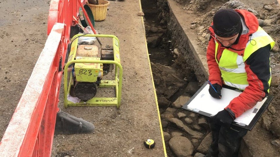
Steven Birch of West Coast Archaeological Services at the excavation at Kingussie (© Highland Council)
In 2018, the cutting of a water pipe trench next to the current town cemetery disturbed human remains. The following archaeological excavation uncovered two large sections of wall which are likely to be the remains of the Carmelite Friary, as well as remains of metalworking dating from the 8th to early 11th century AD (over 1,000 years ago), which may have been associated with the church.
Significant amounts of disarticulated human bones (bones that are separated and no longer attached to one other) were also uncovered within a structure built inside the friary church, which was interpreted as an ossuary – a container or site made to serve as the final resting place of human skeletal remain, often when there isn’t space for a full burial.
In addition, more human remains were found which appeared to lie beneath the church foundations. These may predate the Carmelite Friary and possibly relate to the Columban church. Following studies of the remains, the bones were placed in burial ground near where they were found.
Even this small excavation shows the importance of the site for the Highlands where, unlike other areas in Scotland, few religious houses were established, and where we have limited settlement or metalworking evidence from the medieval period.
Ruthven Barracks
Ruthven Barracks near Kingussie is the best surviving example of four Highland garrisons built by the Hanoverian government in the wake of the Jacobite Rising of 1715. It was designed to house up to 120 soldiers who policed the area and enforced new restrictions on the local population.
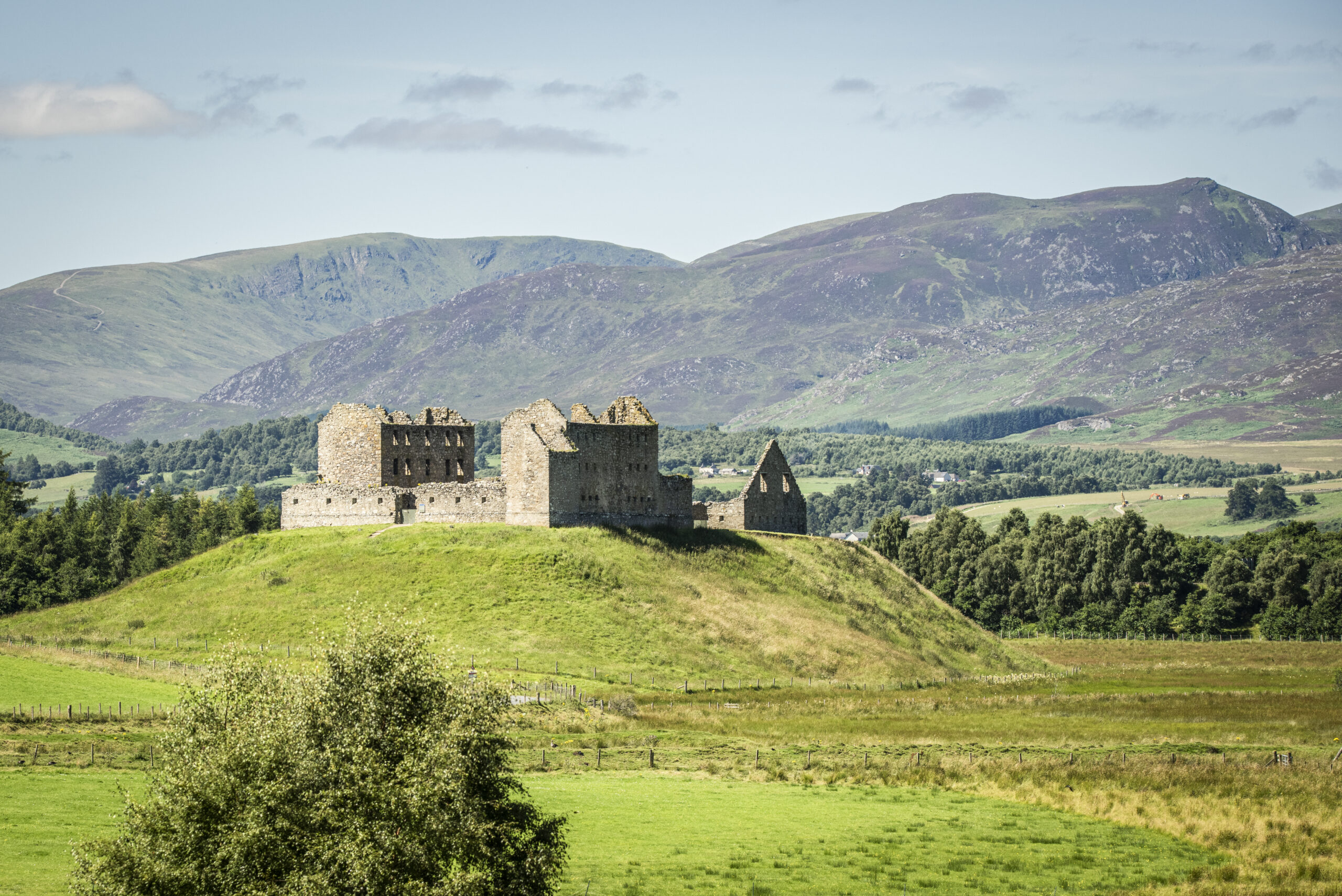
Ruthven Barracks (© James Stevens via VisitCairngorms)
The strategic importance of the site is clear to see today – visible from miles around, it dominates the head of the Spey valley. And the Hanoverian government weren’t the first people to notice. A 14th-century silver groat featuring the head of King David II was found at the site around 2003. Now in Inverness Museum collections, it speaks to the site’s history as the location of a succession of medieval castles occupied by the Comyns (or Cummings) and the Gordons, centuries before the barracks were built.
The barracks saw action twice. A 300-strong Jacobite attack failed to take the site in 1745, but a more heavily-armed attack the next year forced the barracks’ surrender. The Jacobites rallied here after their defeat at Blàr Chùil Lodair (the Battle of Culloden) in 1746, before conceding and burning the garrison, after which it was never repaired.
Today, visitors can wander the ruins and imagine what life was like there at turbulent times in the region’s history.

The medieval coins uncovered at Ruthven Barracks (© Inverness Museum and Art Gallery, High Life Highland)
Humans have lived in the Badenoch area for thousands of years and these sites offer just a taste of the region’s long and varied past.
Ready to explore more stories from Badenoch? Check out the free and low-cost events at the upcoming Badenoch Heritage Festival and download the Badenoch The Storylands app, a new self-guided touring aid which showcases the very best that local heritage has to offer.
The app features walking, cycling and driving tours around Badenoch, highlighting over 75 points of cultural heritage interest, together with a wealth of fascinating stories and legends, augmented reality images of key sites, and inspiring music for visitors to experience.
For more help planning your holiday in Badenoch, be sure to visit the dedicated section of the VisitCairngorms website.
Header Image: Delfour Ring Cairn (© James Stevens via VisitCairngorms)
