What are Statements of Significance?
What makes Skara Brae in Orkney so special? How do you look after a Cold War bunker? What else do we need to know about the Castle of Old Wick in Caithness?
Historic Environment Scotland (HES) produce Statements of Significance for all our Properties in Care (PiC). Statements highlight the key features that make the properties special and help us look after them effectively. While we use the Statements extensively within the organisation to inform our conservation work, provide a basis for interpretation, and highlight areas where more research is needed, all of our Statements are also freely available on our website for anyone to explore.
But their content isn’t set in stone. All Statements – including the ones highlighted below – are continuously revised as there are always new things to learn about our sites through new research.
Hot of the press – Skara Brae
One of HES’s most iconic sites is Skara Brae in Orkney. It’s an absolute privilege to explore the prehistoric site and peer into the stone houses, inhabited well over 4,500 years ago. If you’d like to visit from home, you can head over to Sketchfab for a virtual experience.
In March 2024, HES published the revised statement for Skara Brae with the main work undertaken by the incredible late archaeologist Caroline Wickham-Jones HonFSAScot. We also received input from numerous other experts both internally and externally who have extensive knowledge and a passion for the site. The excitement and enthusiasm that Skara Brae inspires really shines through. The site is full of history, and a lot of mystery, too. Who were the inhabitants? Why did they leave? How large was Skara Brae originally?
From excavations to geophysics, laser scanning, photogrammetry and detailed examination of finds, a lot of work has gone into solving some of these mysteries over the years- and all of these incredible findings informed our Statement.

Skara Brae House 1 (© Katie Logan)
As you can read in the document, the well-preserved Neolithic masonry provides a clear window into architectural styles over 4,500 years ago. And, with the often-intact stone furnishings, they offer an intimate glimpse into Neolithic domestic life. The uniformity in the layout of the structures conforms to what must have been an accepted pattern of stoneworking at the time, that can also be found at other well-preserved Late Neolithic Orcadian sites (for example, at the Ness of Brodgar).
Among the highlights of Skara Brae are its numerous intricate stone carvings which can be found on individual stones in the walls, the furnishings and on portable objects like Skaill knives. Alexandra Shepherd has noticed[1] a similarity between the angular pattern of some of the designs and the natural pattern of fissuring (cracks or divides) on the local sandstone in Orkney – could these have inspired the decoration? All this information and more can be found in the Statement.
A programme of geophysical survey conducted between 2002 – 2011 at the whole of the Heart of Neolithic Orkney World Heritage Sites[2] has also indicated the survival of unexplored remains to the south, immediately inland, of Skara Brae. This suggests that Skara Brae was much larger than what we can see today. However, how large it was precisely at varying time periods in its life, remains unknown, especially as an unknown number of structures were lost to coastal erosion before it was even discovered in AD 1850 (around 200 years ago).
Old vs new – Tomnaverie Stone Circle and the Royal Observer Corps bunker
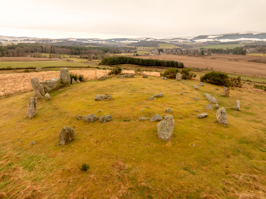
Tomnaverie (pictured at top) is a remarkable recumbent stone circle near Tarland in the Howe of Cromar in Aberdeenshire. Recumbent stone circles like this are very distinctive and found particularly in North-East Scotland. They’re characterised by a large horizontal flat-lying (or ‘recumbent’) stone, set between two upright flankers, with orthostats (upright standing stones) forming the rest of the circle.
The site underwent extensive excavation in 1999 and 2000 which contributed significantly to our understanding not just of Tomnaverie, but of all recumbent stone circles and the wider study of Bronze Age structures, which is reflected in its Statement. After the excavation, the stone circle was carefully restored for public display and gives a much better idea of the aesthetic and design intent of the original formation.
The stone circle sits on top of a distinctive ridge and offers stunning views in all directions. Most notably towards the south-west where the soaring mass of Lochnagar mountain dominates the horizon. A lot of research has gone into understanding the layout of the stone circle, which is also reflected in the Statement. The excavation, for example, revealed that it was most likely that the creators of Tomnaverie knew exactly how they wanted the finished stone circle to look like even though it was constructed in two different phases with an interval of unknown duration between each. Not an easy feat!
The monument was clearly designed to impress – which it does to this day – and has many layers of symbolism. As you’ll read in the Statement, for example, its west-south-west orientation indicates an association with the winter solstice, which can be a metaphor for death. Its design also references funerary architecture of the Neolithic which also signifies death. The colour of stone used, which is mostly red, may have been chosen to indicate a setting sun or even flames of cremation and the circular shape of the monument traces out the solar year which may have been chosen to signify the cycle of life.
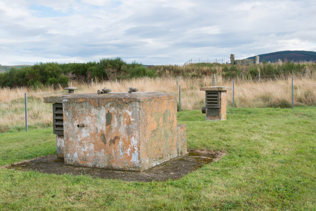
The Royal Observer Corps bunker above-ground structure with Tomnaverie stone circle visible in the background (© Crown Copyright HES)
Standing in the middle of the recumbent stone circle, the modern world can feel very distant. However, walk just about 50 meters south-west from the Stone Circle and you find yourself confronted by a (comparatively) very modern structure – a Cold War bunker with its own Statement of Significance!
The bunker is an underground Royal Observer Corps (ROC) post known as “Tarland”. The construction of the bunker involved blasting into the hard rock. Luckily, the blasting did not damage the stone circle! The bunker was in use from 1960 onwards to determine the location and strength of any possible nuclear explosion and to monitor the location, direction and strength of radioactive fallout. Thankfully it never had to fulfil its role in earnest. The post was in use until 1991 when it was officially closed.
The ROC bunker cannot be accessed, and the above ground features pictured above, mostly made from concrete, stand in contrast to the natural stone used in the recumbent stone circle. Though only connected through their proximity and spectacular open setting, the two sites together offer a pairing of thought-provoking monuments, telling stories from very different periods in human history.
Finding new evidence at Castle of Old Wick
Castle of Old Wick is situated in Caithness – in the northeast of mainland Scotland – and stands proudly on a narrow piece of land projecting into the sea surrounded by cliffs. The Highlands castle is now in ruins and only a stone skeleton of a once grand tower, within low-lying earthworks, now survives.
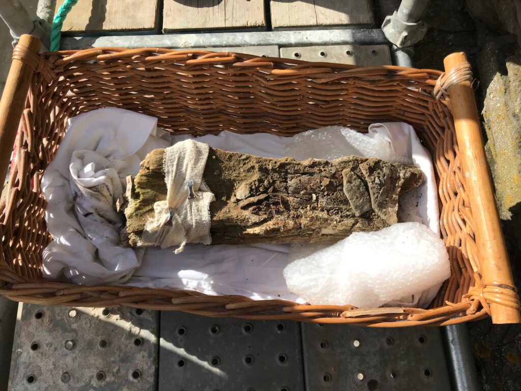
HES Statements not only record the significance of a site in our current understanding, but also highlight major gaps in our understanding. At the Castle of Old Wick, for example, we had very little independent dating evidence from the site. Until recently, dates for the occupation of the castle were solely taken from evidence from documentary references and architectural style, which are not always precise. However, conservation work provided the opportunity to carry out research on some in situ timber (meaning that it was found in the same place where it was first laid).
HES were able to join up with the Castle Studies Trust to fund a project to date the timber. The fragment was carefully removed and examined by researchers from Dendrochronicle who identified it as ‘axe-worked alder’. Further testing revealed that the timber was likely felled either between AD 1515-50 (98% confidence) or AD 1515-35 (68% confidence) and was most likely part of a hanging lum (like a chimney or flue), which formed part of a fireplace.

The Castle of Old Wick and the piece of wood identified as ‘axe-worked alder’ (© Historic Environment Scotland)
Alder wood is common in wetter places and historically was readily available in the north of Scotland. While it’s widely recognised as a material in pre-modern vernacular (everyday) buildings, it’s less reported in high-status contexts. Its use in the high-status Castle of Old Wick is therefore highly unusual, though of course this may be due to the scarce survival of other examples.
The context from which the timber was recovered suggests that it was part of a repair or refurbishment of the tower. It’s therefore not part of the primary-phase construction, which was earlier in date.
Further documentary research has allowed us to create a timeline of figures and events connected to the castle that may have coincided with the installation of the timber. This includes the story of Christian Sutherland and a succession feud between branches of the Sutherland of Duffus family in the early 16th century (around 500 years ago).
An agreement of adjudication (a legal document concerning a resolution to a dispute) between Christian and her son Andrew Oliphant on the one hand, and William Sutherland of Duffus on the other, speaks about the murder of Christian’s second son, Charles, which was either instigated or supported by William. What’s interesting for our purposes is that the agreement also states that the castles of Berriedale and Old Wick had been occupied, damaged and looted. Could the repair to the hanging lum be connected to this episode of violence and destruction?
While we still don’t have a precise date of construction of the original castle, we now have confirmed dates when it was in use and were able to update the Statement. We know so much more about it, all gleaned from just a small piece of wood!
Thee timber had a felling date of 1515-50 (98% confidence) or 1515-35 (68% confidence) (© Historic Environment Scotland)
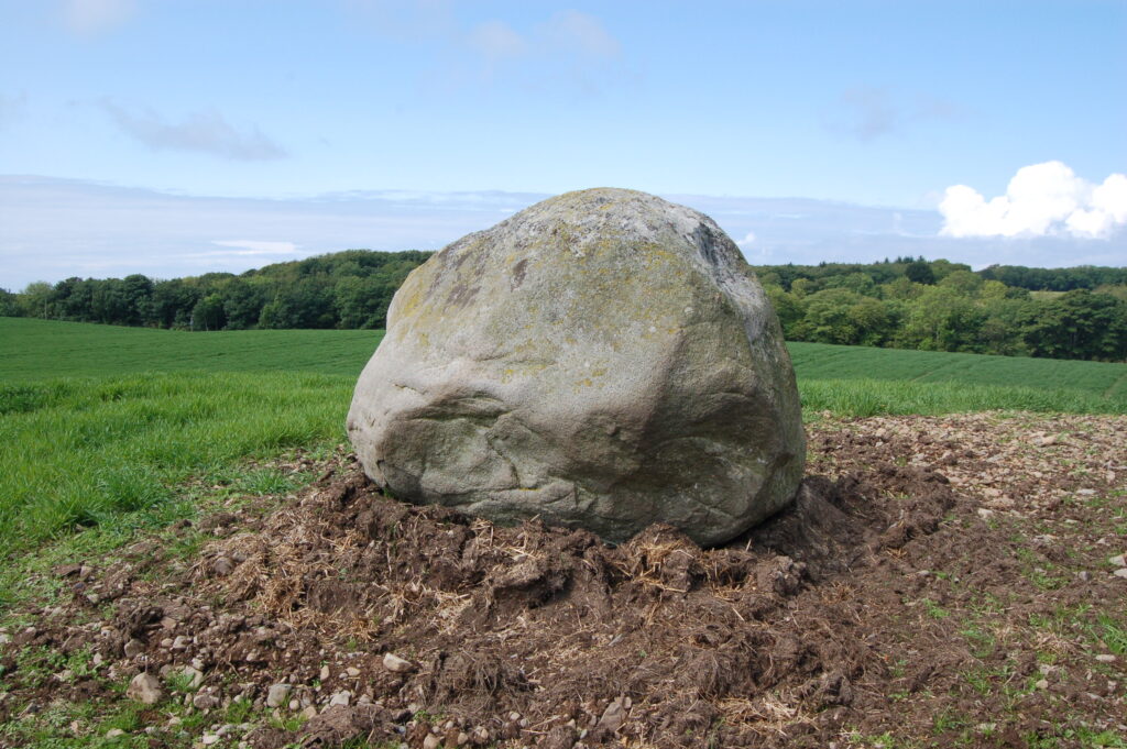
Just a large rock in a field? Meet the Wren’s Egg
One of HES’s more obscure sites is the so-called ‘Wren’s Egg’ in Dumfries & Galloway. The origin of the name is uncertain. Is it just a tongue-in-cheek commentary on the sheer size of the boulder compared to the tiny size of the bird? Or could it have something to do with local traditions?
The monument in HES’s care consists of a pair of standing stones, around 1.5m apart, with a large glacial erratic boulder some 20m to the west. A glacial erratic is a natural phenomenon whereby a boulder is incorporated into a glacier, transported some distance by the moving glacier, and then deposited when the glacier melts. This means that the boulder was not carried to this location by human force.
Looking at it, it appears as just a large lump of rock, squatting in a field and two small stones sitting next to it. Some may find it quite underwhelming, but knowing its story changes this.
Though not consciously placed there, the boulder must have had some importance to the Bronze Age inhabitants of the area over 2,800 years ago, as there are various traces of activity around the site; most noticeably the two standing stones. These form part of the property in care and still stand in their original location, as excavation in 1975 confirmed. Professor Alexander Thom also calculated that the alignment was with the setting sun on the midwinter solstice, suggesting that these stones were carefully placed.
The Wren’s Egg (© Historic Environment Scotland)
On the nearby Milton Hill sits another pair of standing stones of similar shape and stature. These are in line of sight of the Wren’s Egg, and given the proximity and likeness, it is possible that it forms part of a wider monument across the landscape. However, so far there has not been any research into the connection between the two monuments.
In 2012, three cists (stone-lined boxes often used to house human remains) were uncovered and subsequently excavated 150m to the northwest and provide evidence of a Bronze Age funerary landscape, potentially centred on the Wren’s Egg. Several cup and ring marked stones are also found towards the east of the Wren’s Egg (these can be found on the Rock Art Database). This further suggests that the site may have been a focal point for the activities of Bronze Age people, maybe even a broader sacred landscape.
Another interesting facet of the Wren’s Egg is its more recent history. Around 130 years ago in AD 1890 it was one of the first monuments to be taken into state care following the introduction of the 1882 Ancient Monuments Act. It was the 21st guardianship monument in Scotland overall.
When it was first offered into guardianship in AD 1887, the first Inspector of Ancient Monuments, General Pitt Rivers, visited the site, but could not establish the importance of the monument and therefore rejected it for guardianship.
This decision was overturned a few years later ‘because of the value imposed on it by local communities, led by Sir Herbert Maxwell [the landowner at the time]’. This shows that sites were valued not just for the historical or archaeological importance but also through their value to local communities.
Though maybe unassuming at first glance, the Wren’s Egg demonstrates that appearances can be deceiving and that there is more to significance than meets the eye.
This is only a small taster of what makes these four sites important. To delve deeper into the stories of these amazing monuments, head to our website and be inspired by more stories about famous sites like Jarlshof Prehistoric and Norse Settlement, hidden gems like Ruthwell Cross, or your local site.
By Ruth Schieferstein MA MLitt, a Cultural Significance Advisor within the Cultural Resources Team at Historic Environment Scotland. In her role she works on the Statement of Significance programme. Her wider research interests are in Scottish history, heritage and museology.
[1] In her chapter in Neolithic Orkney in Its European Context by Anna Ritchie (Editor), 2000.
[2] Geophysics took place between 2002-2011 at the HONO sites and research published in Landscapes Revealed: Geophysical Survey in the Heart of Neolithic Orkney World Heritage Area 2002-2011 by Amanda Brend et al, 2020.
Header Image: Tomnaverie Stone Circle (© Lee Howard)
