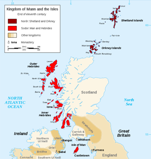
The Kingdom of the Isles: Viking Archaeology in Scotland

Towards the end of the 8th century, Vikings from Scandinavia arrived in Scotland. Their violent attacks on the islands and coastline, in which they looted precious metals and objects, eventually turned to settlement when the raiders decided to stay.
As time went by, the scattered lordships of Norse (a group of Germanic people who inhabited Scandinavia and spoke Old Norse between 800 and 1300) leaders in Scotland were united under Norwegian rule, which was formalised in 1098 when King Eagar (Edgar) formally signed the islands over to Magnus III of Norway.
The area of Norse settlement, known as the Kingdom of the Isles, had two parts: the Suðr-eyjar or South Isles encompassing Innse Gall (the Hebrides) and the Isle of Man; and the Norðr-eyjar or North Isles of Orkney and Shetland, where Norse influence was strongest and most long lasting.
Hundreds of years of Norse settlement has left its mark on the landscape, and under it.
Cross slabs and canals in Na h-Eileanan a-staigh (the Inner Hebrides)
At the beginning of Scotland’s Viking period, Na h-Eileanan Siar (the Outer Hebrides) and the northern Na h-Eileanan a-staigh were predominantly Pictish, whereas the southern Na h-Eileanan a-staigh formed part of the Gaelic kingdom of Dál Riata. Both were affected by Norse activity.
The Abbey at Ì Chaluim Chille (Iona), a beacon of Christianity in the British Isles, was sacked by Vikings in 802 and 806, prompting its monks to conceal or send away most of its treasures. But as well as stealing, the Vikings would go on to lay down roots here; an 11th-century cross slab decorated with Irish and Viking art was found on Ì Chaluim Chille in 1838.
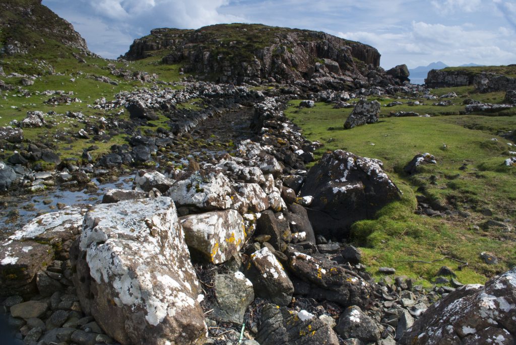
A fascinating site on An t-Eilean Sgitheanach (the Isle of Skye) also demonstrates this interesting parallel between the Viking occupation – raiding – and Norse settlement. Rubha an Dùnain, today an uninhabited peninsula to the south of the Cuillin hills on the island, contains the small Loch na h-Airde, which is connected to the sea by a short artificial canal, referred to as the ‘Viking canal’.
This loch was an important site for maritime activity for many centuries, and it is thought that some of its features, including the stone-built quay, the system to maintain constant water levels, and 12th-century boat timbers were built by Norsemen (although this has come into question recently). The canal may have been used to launch raids as well as connecting An t-Eilean Sgitheanach to the rest of the Kingdom of the Isles.
By 1156 however, the Suðr-eyjar was split so that Na h-Eileanan Siar (the Outer Hebrides) remained under Norwegian control while Na h-Eileanan a-staigh (the Inner Hebrides) broke away under Norse-Celtic leadership.
Raiding and trading in Na h-Eileanan Siar (the Outer Hebrides)
Although Norse contribution to the islands of Na h-Eileanan Siar can still be found in the names of places and people, the archaeological record of this period is limited. The best known finds from this time are the Lewis chess pieces, which date from the mid-12th century.
The 93 pieces, made from elaborately worked walrus ivory and whales’ teeth, probably originated in Norway. It seems likely that the pieces – almost enough to make four whole sets – were buried by a merchant for safe keeping on route to be traded in Ireland.
Since their discovery in 1831, the chess pieces have been used as evidence on both sides of the debate which questions whether the Vikings were primarily raiders or traders. 11 of the pieces are on permanent display in the National Museum of Scotland in Edinburgh, and 82 are in the British Museum collections (with six on loan at Museum nan Eilean in Na h-Eileanan Siar).
Norse influence in Na h-Eileanan Siar waned when Norway ceded the islands, along with the Isle of Man, to Scotland in the 1266 Treaty of Perth in return for £2,500 and guarantees about future Norwegian rights over Orkney and Shetland.
![Almost all of the pieces in the collection are carved from walrus ivory, with a few made instead from whale teeth. The 79[15] chess pieces consist of eight kings, eight queens, 16 bishops, 15 knights, 13 rooks (after the 2019 discovery) and 19 pawns. The heights of the pawns range from 3.5 to 5.8 cm, while the other pieces are between 7 and 10.2 cm. Although there are 19 pawns (a complete set requires 16), they have the greatest range of sizes of all the pieces, which has suggested that the 79 chess pieces might belong to at least five sets.[16] All the pieces are sculptures of human figures, with the exception of the pawns, which are smaller, geometric shapes. The knights are mounted on rather diminutive horses and are shown holding spears and shields. The rooks are standing soldiers or "warders" holding shields and swords; four of the rooks are shown as wild-eyed berserkers biting their shields with battle fury.](https://www.digitscotland.com/wp-content/uploads/2019/07/search-e1690189713441-1024x581.jpg)
Lewis chess pieces (Image © National Museums Scotland)
Conquest and carving in Orkney
The Picts living in Orkney at the time of the Norsemen’s arrival were gradually dispossessed from the late 8th century onwards. How this transition occurred is controversial, and theories range from peaceful integration to enslavement and genocide. What is for certain is that after their first invasion, the Vikings settled in huge droves and brought their families, until eventually Norwegian ruler Harald Fairhair made Orkney and Shetland part of his kingdom in 875.
The Norðr-eyjar has more Viking archaeology than you can shake a stick at. The 30 runic inscriptions at Maeshowe which graffiti the walls of a 5,000-year-old Neolithic chamber are one of the largest, and most famous, collections of runes known in Europe.
In Birsay, the extensive remains of a 10th- or 11th-century Norse settlement overlay the earlier Pictish settlement. Birsay was the seat of the rulers of Orkney before Kirkwall became the centre of power in the 12th century. Here, some Pictish artefacts were found in Norse houses. This may be evidence of peaceful coexistence or they may have been taken by force.
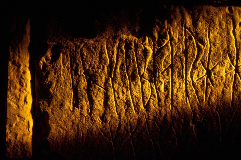
A detail of the runic inscriptions at Maes Howe (the finest chambered tomb in Europe dating from neolithic times), west of Finstown, Mainland, Orkney (Credit: VisitScotland / Paul Tomkins)
A longhouse for a long stay in Shetland
Like in the case of Orkney, the fate of the existing indigenous population of Shetland when Norsemen settled in the 9th century is uncertain. Also like Orkney, the impact of Norse settlement on Shetland lasted for centuries. Even their language, which evolved into the West Nordic language Norn, survived in Shetland into the 19th century.
The Vikings built their farmsteads on existing prehistoric settlements, like at Jarlshof. Excavations there in the 1930s found the first confirmed Norse longhouse in the British Isles. The remains inform us that the farmstead grew and shrank in size over some 12 to 16 generations, telling a story of hundreds of years of Norse development in Shetland – and that once the Vikings arrived, they were here to stay.
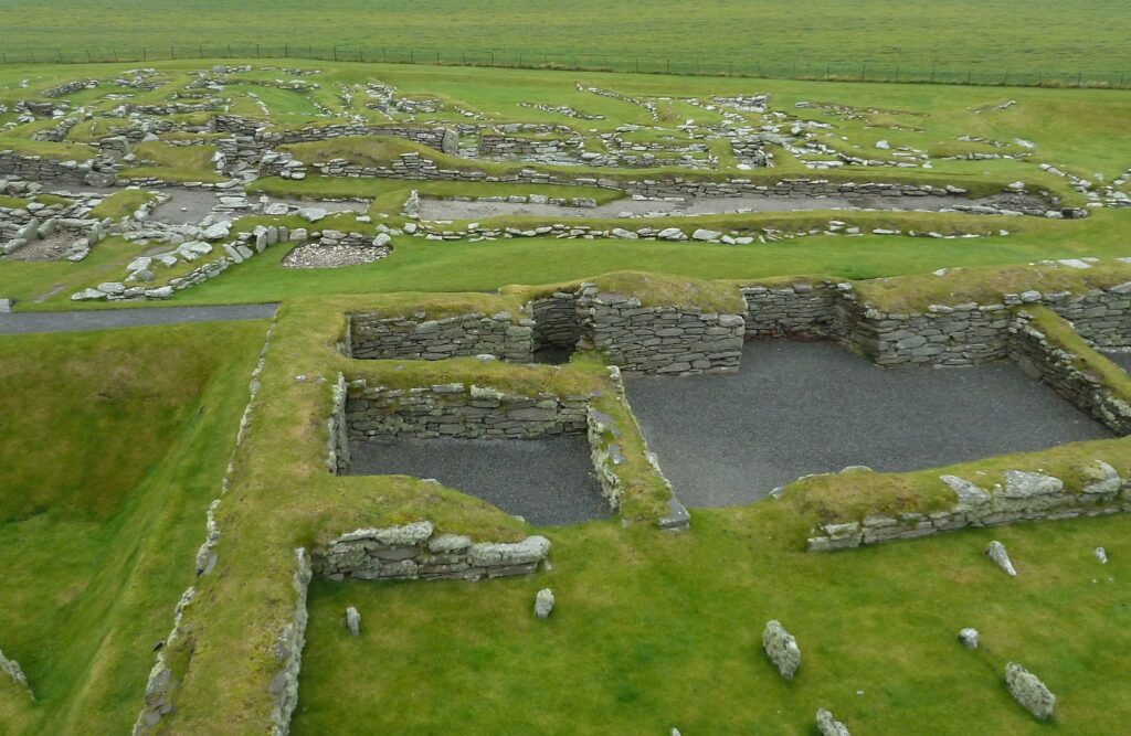
Jarlshof – Norse settlement from the Laird’s house (Image by Rob Farrow, CC BY-SA 2.0)
If you’d like to keep exploring Scotland’s islands, dig into our articles on Arainn (Arran) or Tiriodg (Tiree). Or sign up to the Dig It! Digest to get stories, events and updates delivered straight to your inbox once a month.
Featured image: Viking Longhouse Reconstruction (Image Credit: kjbax via Flickr, CC BY-NC-ND 2.0)
