Halls, Swords and Spears: From Archaeological Evaluation to Excavation in Scotland
How do archaeologists know where to find archaeological sites, features and artefacts? If you’re at the Ring of Brodgar, Maeshowe or Urquhart Castle for instance then the answer is straightforward: it’s upstanding right in front of you! But what about when it’s buried and invisible to the human eye? In this case, there are several techniques that archaeologists can employ to identify where to excavate.
Desk-based assessments (reviewing old maps, books, historical documents, aerial photographs, LiDAR etc), geophysical surveys (used to identify underground anomalies that may be archaeological features) and aerial surveys (low flying photography to observe and record cropmarks) can all identify potential archaeological sites. But one of the most effective methods are archaeological evaluations.

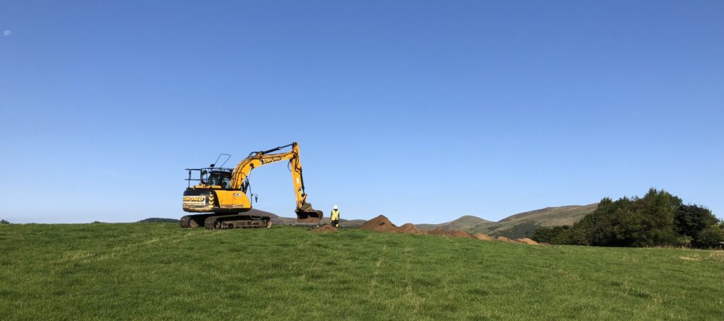
GUARD Archaeologist supervising the machine excavation of an evaluation trench (© GUARD Archaeology Ltd)
What is an Archaeological Evaluation?
Proposed developments, such as new housing, roads and infrastructure, may be flagged up for an archaeological evaluation by the Local Planning Authority’s Archaeologist (archaeological experts who assess potential impacts of development projects and devise ways to address those) if these are located in areas of archaeological potential.
This might be based on historical mapping or previous findings in the locale. The evaluation takes place before construction starts, often as a condition of planning consent, and ensures that any archaeological remains that might survive get recorded and excavated long before building works begin.
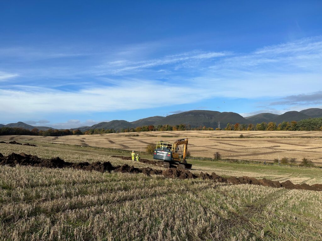
An archaeological evaluation underway. Note the backfilled trenches across the fields in the background (© GUARD Archaeology Ltd)
An archaeological evaluation consists of a series of systematically excavated trenches which investigate between 5% and 10% of a development area. The trenches are excavated using a back-acting machine excavator (backhoe or digger). It’s important that the excavator is fitted with a toothless ditching bucket to ensure a smooth excavated surface as this is vital for enabling the supervising archaeologist to see if anything of archaeological importance is visible.
Sometimes, the trenching is preceded by a metal-detecting survey, for instance where a site lies close to a known battlefield. A metal-detecting survey is useful for finding artefacts that might be buried within the topsoil whereas the trenches examine what is buried beneath the topsoil (the uppermost layer of soil which is free of features or finds in their original context).
The main purpose of an evaluation is to determine if anything of archaeological interest survives. Excavating significant finds is the next phase of work.
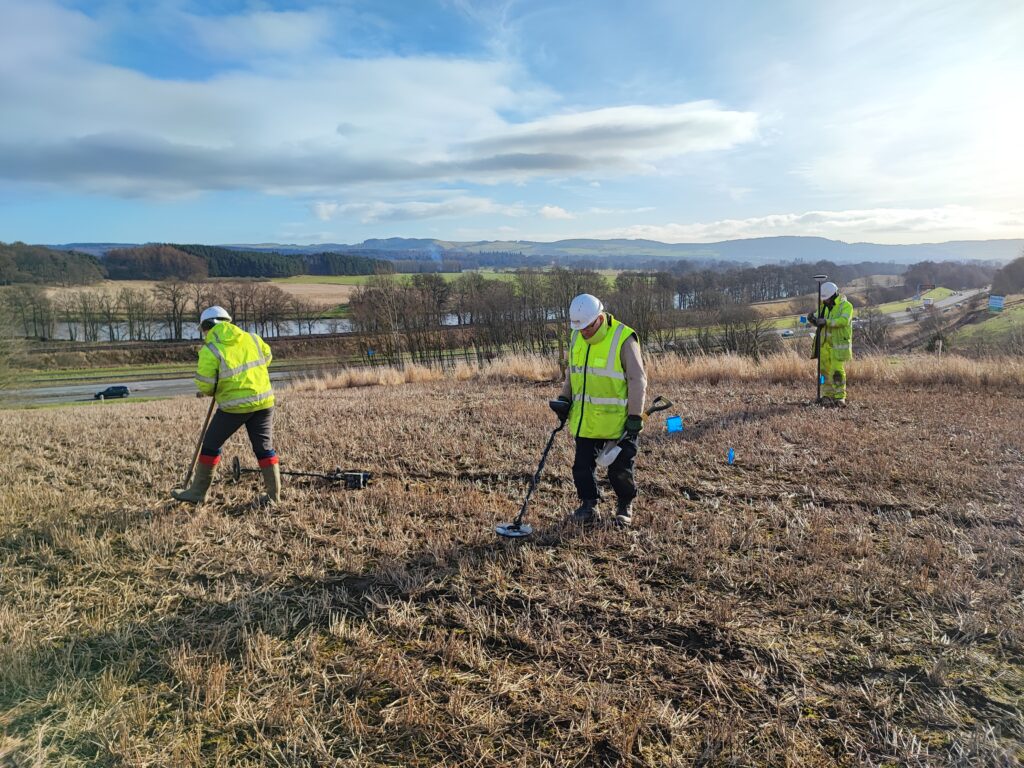
Metal detecting in advance of machine excavation of topsoil (© GUARD Archaeology Ltd)
How an evaluation led to the excavation of prehistoric roundhouses
In January 2023, GUARD Archaeology began an archaeological evaluation ahead of the planned extension of Lomond Quarry near Leslie in Fife.
The work involved the machine excavation of 33 trenches, each 50 m long by 2 m wide, accounting for 5% of the total quarry extension area. We designed a chevron (v-shaped) plan of trenches that would give us the best chance of finding any unknown artefacts or features and took care to avoid electricity cables and gas and water pipes.
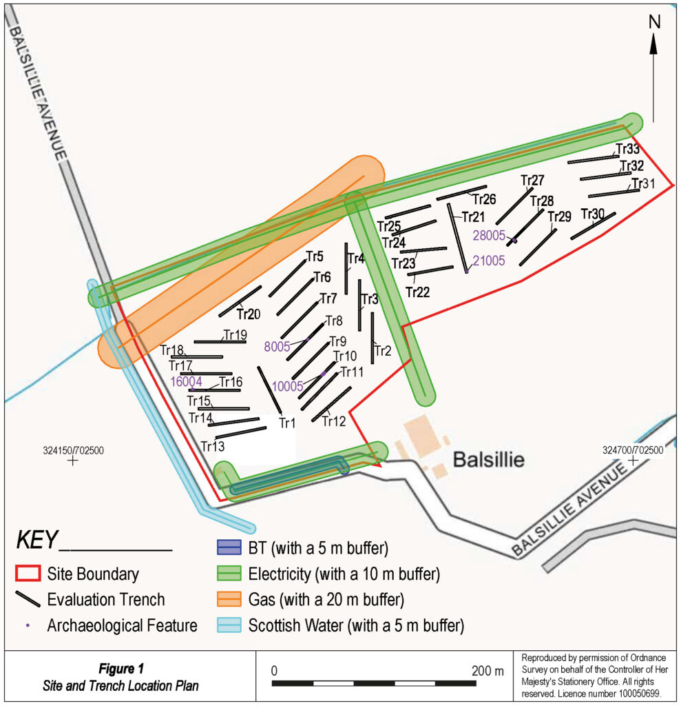
Evaluation Trench Plan (© GUARD Archaeology Ltd)
Under the constant supervision of a GUARD Archaeologist, the topsoil was removed by a 13-ton machine excavator. The soil horizon (the level between the topsoil layer and the subsoil below it) was recorded, photographed and examined. Archaeological features like post-holes and pits (used to hold the structural timbers of the building) often appear as differently coloured marks within the subsoil and it takes some experience to easily spot these.
The trenches we machine-excavated at Lomond Quarry revealed a possible structure and four pits, one of which contained a small sherd (piece) of prehistoric pottery. A single sherd of early Neolithic pottery (from between 5,000 and 6,000 years old) was also recovered from the topsoil in one of the trenches, indicating prehistoric activity here.
This evaluation also highlighted some of the difficulties of investigating Scottish archaeology in winter: the WEATHER! It rained every day and as the water table was already elevated by winter rains, the trenches filled with water as quick as we opened them. This makes it tricky to spot anything of archaeological interest so you have to remain vigilant at all times and act very quickly when you observe possible features.
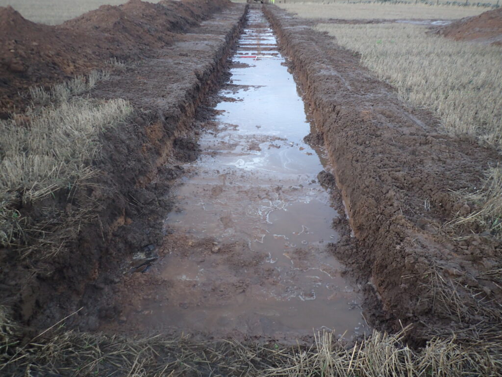
Waterlogged evaluation trench (© GUARD Archaeology Ltd)
When we do observe features, there is much to do. We:
– Clean and expose them
– Take a pre-excavation photograph
– Excavate 50% of them
– Take soil samples (analysis of which can reveal a wealth of information on the site, including how it was used and what the immediate environment was like)
– Make technical drawings of the feature
– Take photographs
– Record the position of the feature with GPS surveying equipment (to record the precise location and dimensions of a feature)
– Then fill in a record sheet describing all aspects of the feature.
This is all done in the pouring rain as the waters rise around your wellies!
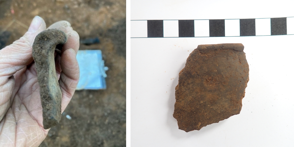
Early Neolithic pottery rim sherd recovered during the evaluation and a prehistoric pottery rim sherd recovered from one of the pits revealed by evaluation trenching (© GUARD Archaeology Ltd)
Once fieldwork was complete, a report was submitted to Fife Council to enable them to decide if the planning condition had been met or whether further investigation was needed.
In April 2023, we began clearing the topsoil around each of the spots where features and artefacts had been encountered during the evaluation and immediately discovered more. Two curvilinear shaped (arranged in curved lines) ditches appeared and then another two. These were cleaned with hoes and trowels which revealed the remains of two prehistoric roundhouses, including one with an intact hearth (fireplace).

The extent of excavation areas at Lomond Quarry (© GUARD Archaeology Ltd)
We continued excavating topsoil around the new features until we had a ten-metre archaeologically sterile buffer zone around each new site, uncovering almost one hectare of ground. This means that we kept stripping the top layer of soil near features until we didn’t find anything nearby; we stopped when it had reached 10 metres from the nearest feature and nothing had been discovered.
As features were revealed, a team of GUARD archaeologists set about excavating and recording them revealing evidence for Neolithic and Bronze Age settlements. All from four little pits!

Two of the prehistoric houses revealed during the excavation (© GUARD Archaeology Ltd)
How an evaluation led to an excavation of a bronze spearhead and sword
Although we don’t encounter archaeology during every evaluation, what happened at Lomond Quarry isn’t unusual.
GUARD Archaeology’s evaluation at Carnoustie in Angus is a prime example. This time, new football pitches were planned and an archaeological evaluation was once again required to meet a planning condition before construction works could commence. This was spurred not by any previous record of discoveries on this site, but because neighbouring fields had contained archaeological features.
The evaluation first revealed a small number of pits. This led to the excavation of the surrounding ground to determine the extent of the features, revealing the remains of several prehistoric houses. So far, so good. But the best was yet to come.
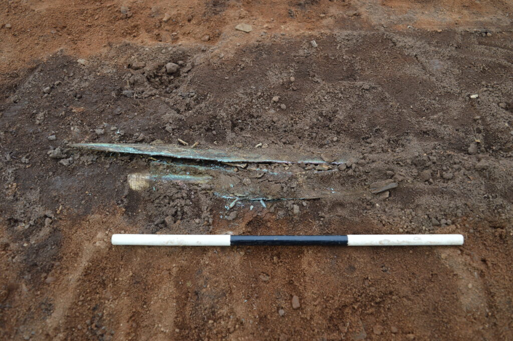
First sight of the Bronze Age hoard revealed at Carnoustie (© GUARD Archaeology Ltd)
As the excavation continued, a large pit was uncovered just below the topsoil, from which a glint of gold was spotted. But it was late Friday morning, and we couldn’t let this lie here over the whole weekend!
Without time to excavate it there and then, our team instead excavated around the entirety of the pit, so that they could wrap the pit itself up and take it back to GUARD Archaeology’s Finds Lab.
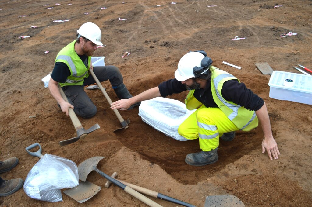
GUARD Archaeologists lifting the soil block containing the fill of the pit and its hoard (© GUARD Archaeology Ltd
Careful excavation in laboratory conditions revealed that the pit contained a gold-decorated bronze spearhead wrapped in sheepskin, a bronze sword with a wooden scabbard wrapped in woollen cloth and a large bronze pin.
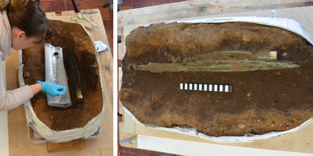
Excavation of the hoard in the GUARD Finds Lab and the Carnoustie Hoard beginning to emerge from the dark soil of the pit it had been buried in 3000 years ago (© GUARD Archaeology Ltd)
And that wasn’t all we found at Carnoustie. The pit containing the hoard lay within the middle of a Bronze Age settlement, which itself lay over the remains of one of the largest Neolithic halls ever found in Scotland.
And none of this was apparent before we began our evaluation.
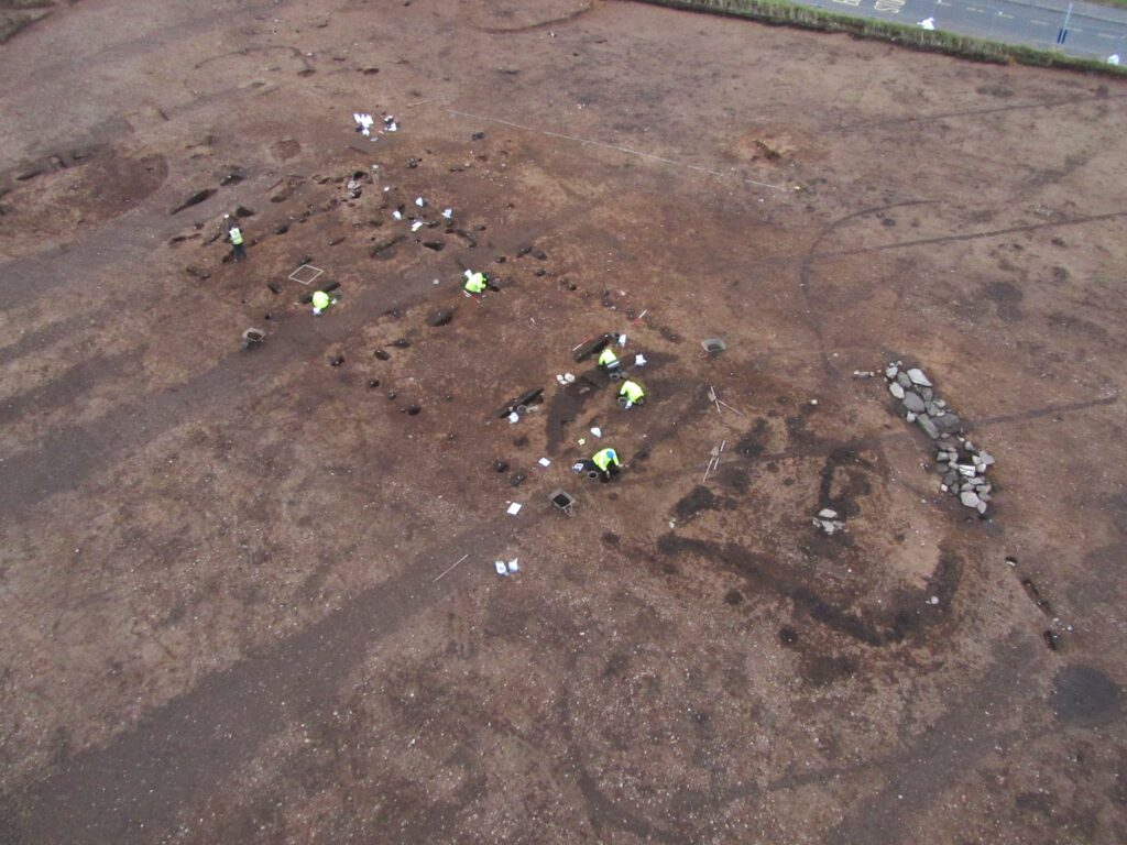
GUARD Archaeologists excavating the Neolithic Hall at Carnoustie. The circular remains of the Bronze Age houses, amongst which the hoard pit was found, lies near the top left of the photo. The linear stone feature to the right of the Neolithic Hall dates to the Pictish period (© GUARD Archaeology Ltd)
Evaluations are the most useful way of determining if unknown features or artefacts survive beneath the ground and enables archaeologists to assess the potential of a site. This usually takes place well in advance of construction (and developers often budget this into their timeframe planning) which allows the surviving remains to be excavated with minimal disruption to construction works; or may even enable development plans to change so that the archaeology is avoided altogether.
As these examples demonstrate, some of the most amazing archaeological remains from the past have been uncovered ahead of development work, so it’s a crucial part of uncovering Scotland’s stories.
By Alun Woodward. Alun is a Senior Project Archaeologist at GUARD Archaeology Ltd and has worked on numerous archaeological evaluations and excavations across Scotland.
Tweet
Header Image: © GUARD Archaeology Ltd.
